Antagan Segunda elevation
Antagan Segunda (Cagayan Valley, Province of Isabela), Philippines elevation is 48 meters and Antagan Segunda elevation in feet is 157 ft above sea level [src 1]. Antagan Segunda is a populated place (feature code) with elevation that is 40 meters (131 ft) smaller than average city elevation in Philippines.
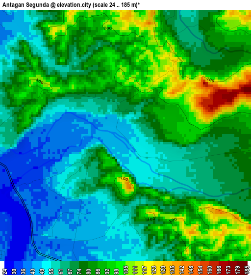
Below is the Elevation map of Antagan Segunda, which displays elevation range with different colors. Scale of the first map is from 24 to 185 m (79 to 607 ft) with average elevation of 73.4 meters (=241 ft) [note 1]
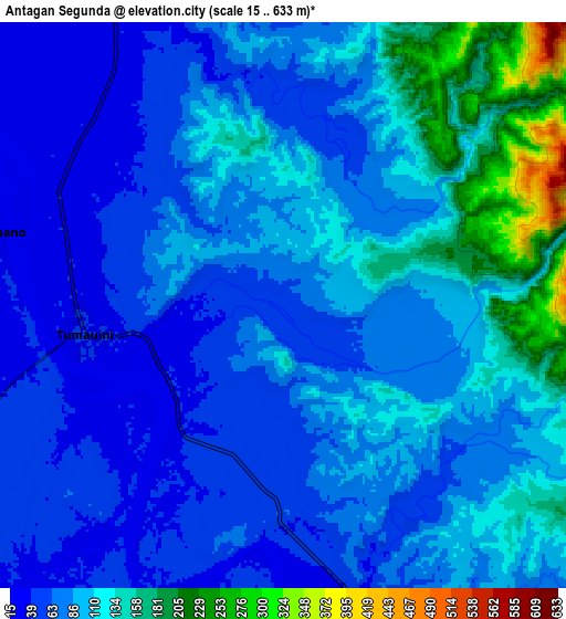
These maps also provides idea of topography and contour of this city, they are displayed at different zoom levels. More info about maps, scale and edge coordinates you can find below images.
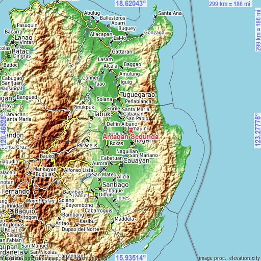
| \ | Map #1 | Map #2 | Topo.Map |
| Scale [m] | 24..185 m | 15..633 m | × |
| Scale [ft] | 79..607 ft | 49..2077 ft | × |
| Average | 73.4 m = 241 ft | 92.4 m = 303 ft | × |
| Width | 9.33 km = 5.8 mi | 18.66 km = 11.6 mi | 298.6 km = 185.5 mi |
| Height | 9.33 km = 5.8 mi | 18.66 km = 11.6 mi | 298.6 km = 185.5 mi |
| ↑Max Latitude | 17.324636° | 17.366583° | 18.62043° |
| Latitude at center | 17.28268° | 17.28268° | 17.28268° |
| ↓Min Latitude | 17.240714° | 17.198738° | 15.93514° |
| ← Min Longitude | 121.827585° | 121.783639° | 120.46528° |
| Longitude center | 121.87153° | 121.87153° | 121.87153° |
| →Max Longitude | 121.915475° | 121.959421° | 123.27778° |
Nearby cities:
Cities around Antagan Segunda sort by population:
• Ilagan elevation 55 m
15 km,  172°
172°
• Ragan Norte 32 m
11.3 km,  293°
293°
• Tumauini 39 m
6.7 km,  264°
264°
• Bulu 29 m
12.5 km,  296°
296°
• Masipi West 45 m
11.3 km,  341°
341°
• San Pedro 34 m
9.3 km, 172°
• Ganapi 43 m
9 km,  184°
184°
• San Antonio 40 m
8.6 km, 263°
• Pilig 34 m
12.3 km, 302°
• Ugad 36 m
8 km, 290°
• Manaring 58 m
12.6 km,  164°
164°
• Magsaysay 38 m
10.4 km, 285°
Multilingual:
 En español:
Antagan Segunda elevación 48 m.
 En France:
Antagan Segunda élévation 48 m.
 Auf Deutsch:
Antagan Segunda höhe über dem Meeresspiegel ist 48 m.

Sources and notes:
- [note 1] Map square and city borders are not equal. Map elevation data is calculated only from area inside that square.
- [src 1] Elevation data from geonames database provided with same terms of usage.
- [src 2] The elevation map of Antagan Segunda is generated using elevation data from NASA's 3 arcsec (90m) resolution SRTM data.
- [src 3] Base (background) map © OpenStreetMap contributors tiles are generated by Geofabrik and OpenTopoMap.
Copyright & License:
This Antagan Segunda Elevation Map is licensed under CC BY-SA. You may reuse any part from this page, if you give a proper credit by linking to this URL:
 More info on terms of use page.