Azagra elevation
Azagra (Central Visayas, Province of Negros Oriental), Philippines elevation is 27 meters and Azagra elevation in feet is 89 ft above sea level [src 1]. Azagra is a populated place (feature code) with elevation that is 61 meters (200 ft) smaller than average city elevation in Philippines.
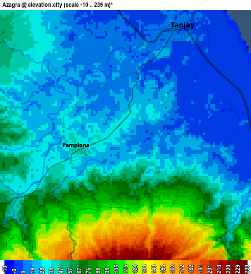
Below is the Elevation map of Azagra, which displays elevation range with different colors. Scale of the first map is from -10 to 239 m (-33 to 784 ft) with average elevation of 49.7 meters (=163 ft) [note 1]
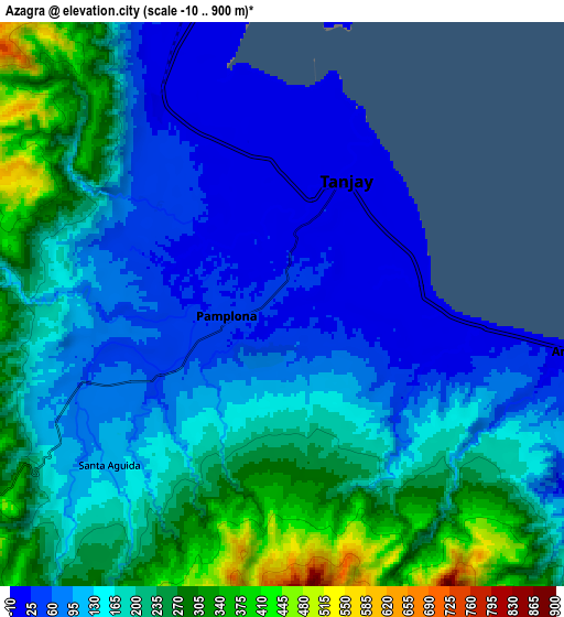
These maps also provides idea of topography and contour of this city, they are displayed at different zoom levels. More info about maps, scale and edge coordinates you can find below images.
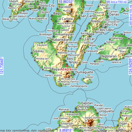
| \ | Map #1 | Map #2 | Topo.Map |
| Scale [m] | -10..239 m | -10..900 m | × |
| Scale [ft] | -33..784 ft | -33..2953 ft | × |
| Average | 49.7 m = 163 ft | 164 m = 538 ft | × |
| Width | 9.64 km = 6 mi | 19.28 km = 12 mi | 308.4 km = 191.6 mi |
| Height | 9.64 km = 6 mi | 19.28 km = 12 mi | 308.5 km = 191.7 mi |
| ↑Max Latitude | 9.521243° | 9.56458° | 10.86202° |
| Latitude at center | 9.4779° | 9.4779° | 9.4779° |
| ↓Min Latitude | 9.434552° | 9.391198° | 8.08818° |
| ← Min Longitude | 123.092755° | 123.048809° | 121.73045° |
| Longitude center | 123.1367° | 123.1367° | 123.1367° |
| →Max Longitude | 123.180645° | 123.224591° | 124.54295° |
Nearby cities:
Cities around Azagra sort by population:
• Tanjay elevation 10 m
4.9 km,  28°
28°
• Pamplona 40 m
2 km,  252°
252°
• Novallas 15 m
4.1 km,  337°
337°
• Santa Cruz 19 m
7.2 km,  331°
331°
• Polo 9 m
4.8 km,  85°
85°
• Jugno 11 m
7.4 km,  98°
98°
• Tandayag 26 m
10.5 km, 104°
• Okiot 6 m
10.4 km,  18°
18°
• Silab 141 m
6.4 km,  133°
133°
• Datagon 87 m
6.3 km,  235°
235°
• Balayong 178 m
8.2 km,  267°
267°
• Jantianon 125 m
4.9 km,  139°
139°
Multilingual:
 En español:
Azagra elevación 27 m.
 En France:
Azagra élévation 27 m.


Sources and notes:
- [note 1] Map square and city borders are not equal. Map elevation data is calculated only from area inside that square.
- [src 1] Elevation data from geonames database provided with same terms of usage.
- [src 2] The elevation map of Azagra is generated using elevation data from NASA's 3 arcsec (90m) resolution SRTM data.
- [src 3] Base (background) map © OpenStreetMap contributors tiles are generated by Geofabrik and OpenTopoMap.
Copyright & License:
This Azagra Elevation Map is licensed under CC BY-SA. You may reuse any part from this page, if you give a proper credit by linking to this URL:
 More info on terms of use page.