Bagong Barrio elevation
Bagong Barrio (Central Luzon, Province of Bulacan), Philippines elevation is 25 meters and Bagong Barrio elevation in feet is 82 ft above sea level [src 1]. Bagong Barrio is a populated place (feature code) with elevation that is 63 meters (207 ft) smaller than average city elevation in Philippines.
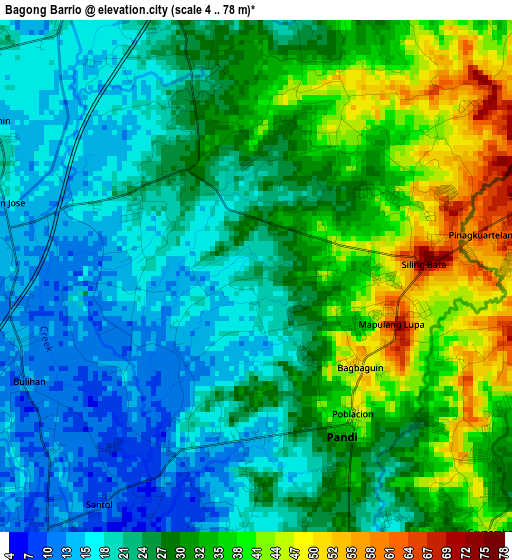
Below is the Elevation map of Bagong Barrio, which displays elevation range with different colors. Scale of the first map is from 4 to 78 m (13 to 256 ft) with average elevation of 27.5 meters (=90 ft) [note 1]
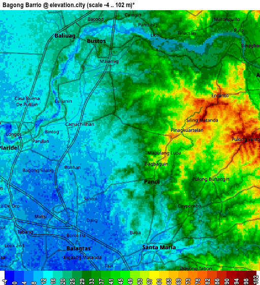
These maps also provides idea of topography and contour of this city, they are displayed at different zoom levels. More info about maps, scale and edge coordinates you can find below images.
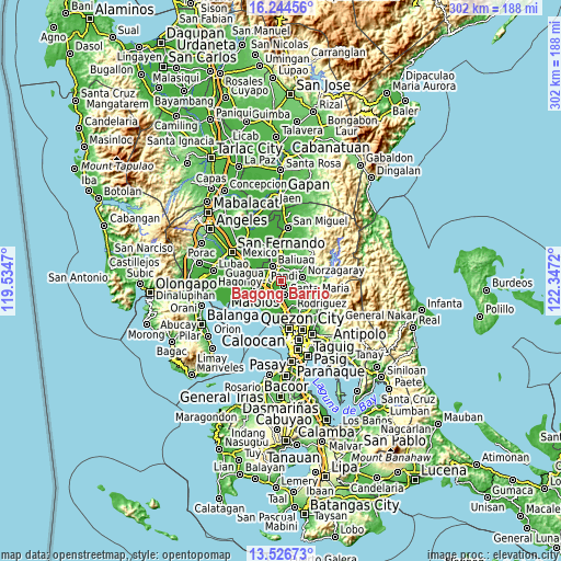
| \ | Map #1 | Map #2 | Topo.Map |
| Scale [m] | 4..78 m | -4..102 m | × |
| Scale [ft] | 13..256 ft | -13..335 ft | × |
| Average | 27.5 m = 90 ft | 26.6 m = 87 ft | × |
| Width | 9.44 km = 5.9 mi | 18.89 km = 11.7 mi | 302.2 km = 187.8 mi |
| Height | 9.44 km = 5.9 mi | 18.89 km = 11.7 mi | 302.2 km = 187.8 mi |
| ↑Max Latitude | 14.932395° | 14.974853° | 16.24456° |
| Latitude at center | 14.88993° | 14.88993° | 14.88993° |
| ↓Min Latitude | 14.847456° | 14.804974° | 13.52673° |
| ← Min Longitude | 120.897005° | 120.853059° | 119.5347° |
| Longitude center | 120.94095° | 120.94095° | 120.94095° |
| →Max Longitude | 120.984895° | 121.028841° | 122.3472° |
Nearby cities:
Cities around Bagong Barrio sort by population:
• Guyong elevation 42 m
7.2 km,  146°
146°
• Baliuag 22 m
8.6 km,  326°
326°
• Bustos 13 m
8 km,  341°
341°
• Pandi 41 m
3.3 km, 147°
• Culianin 15 m
5.4 km,  301°
301°
• Bulihan 13 m
5.1 km,  252°
252°
• Pulong Gubat 12 m
5.1 km,  227°
227°
• Niugan 28 m
6.8 km,  24°
24°
• Liciada 27 m
2.9 km, 340°
• Manatal 12 m
3 km,  241°
241°
• Santa Maria 18 m
8.1 km,  162°
162°
• San Rafael 28 m
6.9 km, 19°
Multilingual:
 En español:
Bagong Barrio elevación 25 m.
 En France:
Bagong Barrio élévation 25 m.
 Auf Deutsch:
Bagong Barrio höhe über dem Meeresspiegel ist 25 m.

Sources and notes:
- [note 1] Map square and city borders are not equal. Map elevation data is calculated only from area inside that square.
- [src 1] Elevation data from geonames database provided with same terms of usage.
- [src 2] The elevation map of Bagong Barrio is generated using elevation data from NASA's 3 arcsec (90m) resolution SRTM data.
- [src 3] Base (background) map © OpenStreetMap contributors tiles are generated by Geofabrik and OpenTopoMap.
Copyright & License:
This Bagong Barrio Elevation Map is licensed under CC BY-SA. You may reuse any part from this page, if you give a proper credit by linking to this URL:
 More info on terms of use page.