Baguio elevation
Baguio (Cordillera, Province of Benguet), Philippines elevation is 1493 meters and Baguio elevation in feet is 4898 ft above sea level [src 1]. Baguio is a seat of a first-order administrative division (feature code) with elevation that is 1405 meters (4610 ft) bigger than average city elevation in Philippines.
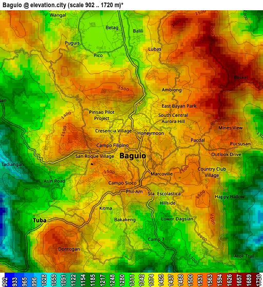
Below is the Elevation map of Baguio, which displays elevation range with different colors. Scale of the first map is from 902 to 1720 m (2959 to 5643 ft) with average elevation of 1388.4 meters (=4555 ft) [note 1]
These maps also provides idea of topography and contour of this city, they are displayed at different zoom levels. More info about maps, scale and edge coordinates you can find below images.
| \ | Map #1 | Map #2 | Topo.Map |
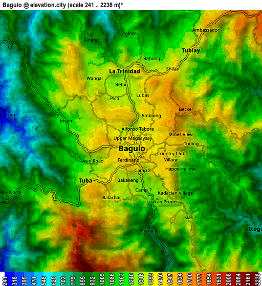
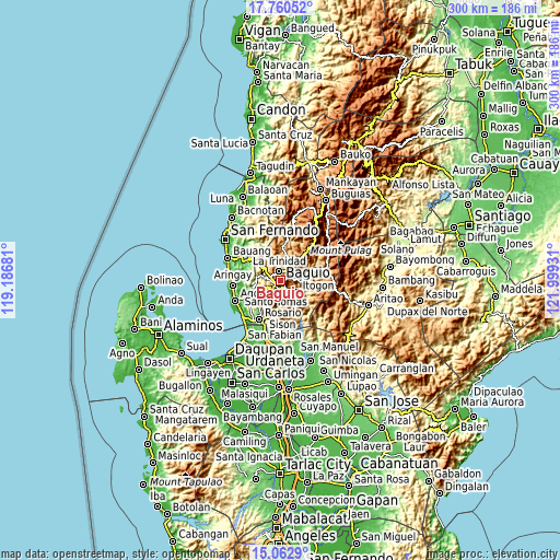
| Scale [m] | 902..1720 m | 241..2238 m | × |
| Scale [ft] | 2959..5643 ft | 791..7343 ft | × |
| Average | 1388.4 m = 4555 ft | 1184.4 m = 3886 ft | × |
| Width | 9.37 km = 5.8 mi | 18.75 km = 11.7 mi | 299.9 km = 186.3 mi |
| Height | 9.37 km = 5.8 mi | 18.75 km = 11.7 mi | 300 km = 186.4 mi |
| ↑Max Latitude | 16.458539° | 16.500679° | 17.76052° |
| Latitude at center | 16.41639° | 16.41639° | 16.41639° |
| ↓Min Latitude | 16.374232° | 16.332064° | 15.0629° |
| ← Min Longitude | 120.549115° | 120.505169° | 119.18681° |
| Longitude center | 120.59306° | 120.59306° | 120.59306° |
| →Max Longitude | 120.637005° | 120.680951° | 121.99931° |
Nearby cities:
Cities around Baguio sort by population:
• La Trinidad elevation 1318 m
4.3 km,  352°
352°
• Itogon 808 m
10.7 km,  123°
123°
• Tuding 1286 m
5.3 km,  96°
96°
• Loacan 1045 m
16.8 km,  27°
27°
• Tublay 971 m
14.2 km,  7°
7°
• Taloy 321 m
13.6 km,  227°
227°
• Tabaan 394 m
15.3 km,  212°
212°
• Sablan 581 m
13.5 km,  309°
309°
• Pugo 65 m
17.1 km, 232°
• Nangalisan 183 m
12.5 km,  279°
279°
• Bayabas 754 m
9 km,  294°
294°
• Tuba 1108 m
12 km,  202°
202°
Multilingual:
 En español:
Baguio elevación 1493 m.
 En France:
Baguio élévation 1493 m.


Sources and notes:
- [note 1] Map square and city borders are not equal. Map elevation data is calculated only from area inside that square.
- [src 1] Elevation data from geonames database provided with same terms of usage.
- [src 2] The elevation map of Baguio is generated using elevation data from NASA's 3 arcsec (90m) resolution SRTM data.
- [src 3] Base (background) map © OpenStreetMap contributors tiles are generated by Geofabrik and OpenTopoMap.
Copyright & License:
This Baguio Elevation Map is licensed under CC BY-SA. You may reuse any part from this page, if you give a proper credit by linking to this URL:
 More info on terms of use page.