Balibago elevation
Balibago (Calabarzon, Province of Batangas), Philippines elevation is 61 meters and Balibago elevation in feet is 200 ft above sea level [src 1]. Balibago is a populated place (feature code) with elevation that is 27 meters (89 ft) smaller than average city elevation in Philippines.
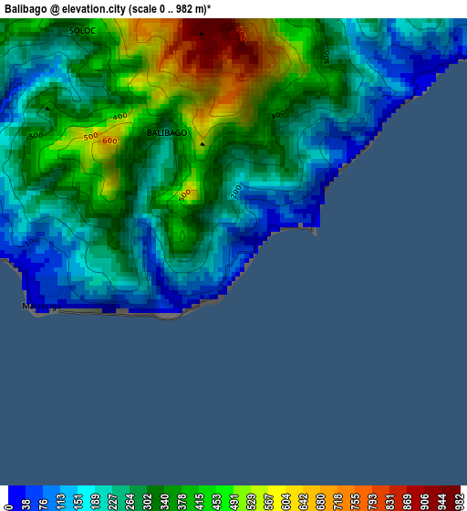
Below is the Elevation map of Balibago, which displays elevation range with different colors. Scale of the first map is from 0 to 982 m (0 to 3222 ft) with average elevation of 308.7 meters (=1013 ft) [note 1]
These maps also provides idea of topography and contour of this city, they are displayed at different zoom levels. More info about maps, scale and edge coordinates you can find below images.
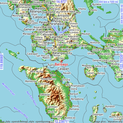
| \ | Map #1 | Topo.Map |
| Scale [m] | 0..982 m | × |
| Scale [ft] | 0..3222 ft | × |
| Average | 308.7 m = 1013 ft | × |
| Width | 9.5 km = 5.9 mi | 303.9 km = 188.8 mi |
| Height | 9.5 km = 5.9 mi | 303.9 km = 188.8 mi |
| ↑Max Latitude | 13.652008° | 14.972° |
| Latitude at center | 13.6093° | 13.6093° |
| ↓Min Latitude | 13.566585° | 12.23871° |
| ← Min Longitude | 121.253155° | 119.89085° |
| Longitude center | 121.2971° | 121.2971° |
| →Max Longitude | 121.341045° | 122.70335° |
Nearby cities:
Cities around Balibago sort by population:
• Laiya elevation 31 m
13.7 km,  54°
54°
• Calubcub Dos 22 m
19.8 km,  43°
43°
• Talahib Payap 118 m
18.3 km,  288°
288°
• Lobo 17 m
10.2 km, 294°
• San Isidro 172 m
19.1 km,  337°
337°
• Mapulo 243 m
18.3 km,  318°
318°
• Quipot 35 m
21.8 km,  29°
29°
• Dagatan 173 m
17.9 km, 323°
• Haligue 369 m
20.5 km, 288°
• Sampiro 50 m
21.6 km, 25°
• Pulangbato 59 m
19.1 km, 32°
• Banalo 32 m
13.1 km, 288°
Multilingual:
 En español:
Balibago elevación 61 m.
 En France:
Balibago élévation 61 m.


Sources and notes:
- [note 1] Map square and city borders are not equal. Map elevation data is calculated only from area inside that square.
- [src 1] Elevation data from geonames database provided with same terms of usage.
- [src 2] The elevation map of Balibago is generated using elevation data from NASA's 3 arcsec (90m) resolution SRTM data.
- [src 3] Base (background) map © OpenStreetMap contributors tiles are generated by Geofabrik and OpenTopoMap.
Copyright & License:
This Balibago Elevation Map is licensed under CC BY-SA. You may reuse any part from this page, if you give a proper credit by linking to this URL:
 More info on terms of use page.