Banog Sur elevation
Banog Sur (Ilocos, Province of Pangasinan), Philippines elevation is 22 meters and Banog Sur elevation in feet is 72 ft above sea level [src 1]. Banog Sur is a populated place (feature code) with elevation that is 66 meters (217 ft) smaller than average city elevation in Philippines.
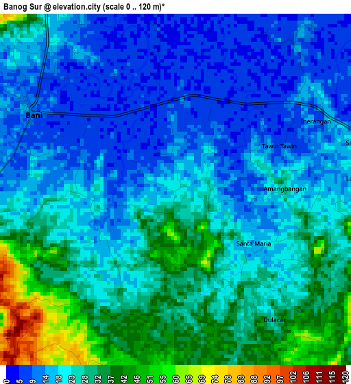
Below is the Elevation map of Banog Sur, which displays elevation range with different colors. Scale of the first map is from 0 to 120 m (0 to 394 ft) with average elevation of 23.1 meters (=76 ft) [note 1]
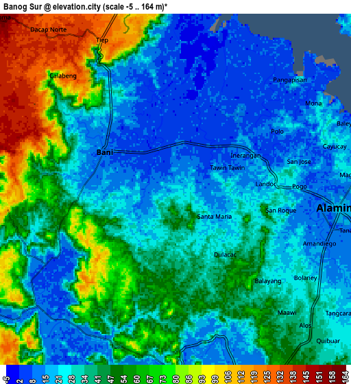
These maps also provides idea of topography and contour of this city, they are displayed at different zoom levels. More info about maps, scale and edge coordinates you can find below images.
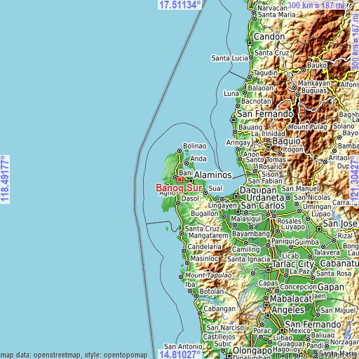
| \ | Map #1 | Map #2 | Topo.Map |
| Scale [m] | 0..120 m | -5..164 m | × |
| Scale [ft] | 0..394 ft | -16..538 ft | × |
| Average | 23.1 m = 76 ft | 39.2 m = 129 ft | × |
| Width | 9.39 km = 5.8 mi | 18.77 km = 11.7 mi | 300.3 km = 186.6 mi |
| Height | 9.39 km = 5.8 mi | 18.77 km = 11.7 mi | 300.4 km = 186.7 mi |
| ↑Max Latitude | 16.207623° | 16.249818° | 17.51134° |
| Latitude at center | 16.16542° | 16.16542° | 16.16542° |
| ↓Min Latitude | 16.123208° | 16.080986° | 14.81027° |
| ← Min Longitude | 119.854075° | 119.810129° | 118.49177° |
| Longitude center | 119.89802° | 119.89802° | 119.89802° |
| →Max Longitude | 119.941965° | 119.985911° | 121.30427° |
Nearby cities:
Cities around Banog Sur sort by population:
• Alaminos elevation 15 m
8.9 km,  96°
96°
• Lucap 8 m
11.5 km,  75°
75°
• Bangan-Oda 13 m
9.6 km,  228°
228°
• Tagudin 54 m
11.2 km,  147°
147°
• Pangapisan 32 m
8.4 km,  48°
48°
• Caabiangan 17 m
9.1 km,  161°
161°
• Bued 19 m
10.8 km,  92°
92°
• Polo 18 m
6.4 km,  57°
57°
• Tiep 127 m
9 km,  333°
333°
• Ranao 152 m
10 km,  298°
298°
• Cayungnan 21 m
7.4 km,  241°
241°
• Bani 11 m
4.5 km, 299°
Multilingual:
 En español:
Banog Sur elevación 22 m.
 En France:
Banog Sur élévation 22 m.
 Auf Deutsch:
Banog Sur höhe über dem Meeresspiegel ist 22 m.

Sources and notes:
- [note 1] Map square and city borders are not equal. Map elevation data is calculated only from area inside that square.
- [src 1] Elevation data from geonames database provided with same terms of usage.
- [src 2] The elevation map of Banog Sur is generated using elevation data from NASA's 3 arcsec (90m) resolution SRTM data.
- [src 3] Base (background) map © OpenStreetMap contributors tiles are generated by Geofabrik and OpenTopoMap.
Copyright & License:
This Banog Sur Elevation Map is licensed under CC BY-SA. You may reuse any part from this page, if you give a proper credit by linking to this URL:
 More info on terms of use page.