Basdiot elevation
Basdiot (Central Visayas, Province of Cebu), Philippines elevation is 15 meters and Basdiot elevation in feet is 49 ft above sea level [src 1]. Basdiot is a populated place (feature code) with elevation that is 73 meters (240 ft) smaller than average city elevation in Philippines.
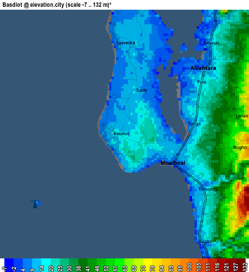
Below is the Elevation map of Basdiot, which displays elevation range with different colors. Scale of the first map is from -7 to 132 m (-23 to 433 ft) with average elevation of 25 meters (=82 ft) [note 1]
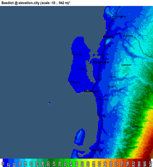
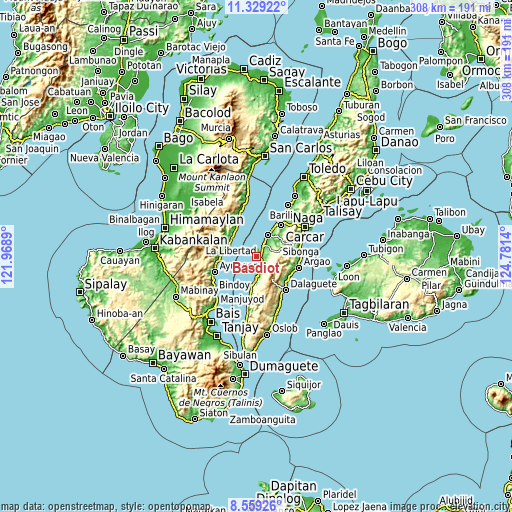
These maps also provides idea of topography and contour of this city, they are displayed at different zoom levels. More info about maps, scale and edge coordinates you can find below images.
| \ | Map #1 | Map #2 | Topo.Map |
| Scale [m] | -7..132 m | -10..942 m | × |
| Scale [ft] | -23..433 ft | -33..3091 ft | × |
| Average | 25 m = 82 ft | 147.4 m = 484 ft | × |
| Width | 9.63 km = 6 mi | 19.25 km = 12 mi | 308 km = 191.4 mi |
| Height | 9.63 km = 6 mi | 19.25 km = 12 mi | 308 km = 191.4 mi |
| ↑Max Latitude | 9.990462° | 10.033738° | 11.32922° |
| Latitude at center | 9.94718° | 9.94718° | 9.94718° |
| ↓Min Latitude | 9.903892° | 9.860599° | 8.55926° |
| ← Min Longitude | 123.331205° | 123.287259° | 121.9689° |
| Longitude center | 123.37515° | 123.37515° | 123.37515° |
| →Max Longitude | 123.419095° | 123.463041° | 124.7814° |
Nearby cities:
Cities around Basdiot sort by population:
• Moalboal elevation 24 m
2.7 km,  99°
99°
• Alcantara 17 m
4.6 km,  47°
47°
• Dumanjog 11 m
13.9 km,  28°
28°
• Badian 25 m
9.5 km,  165°
165°
• Malhiao 40 m
7.7 km,  153°
153°
• Cogon 64 m
13.2 km,  40°
40°
• Santa Cruz 20 m
7.9 km, 32°
• Cansuje 645 m
13.5 km, 101°
• Banhigan 21 m
9.9 km, 171°
• Bugas 21 m
6.4 km, 149°
• Saavedra 11 m
4.2 km,  354°
354°
• Ronda 6 m
6.9 km, 33°
Multilingual:
 En español:
Basdiot elevación 15 m.
 En France:
Basdiot élévation 15 m.


Sources and notes:
- [note 1] Map square and city borders are not equal. Map elevation data is calculated only from area inside that square.
- [src 1] Elevation data from geonames database provided with same terms of usage.
- [src 2] The elevation map of Basdiot is generated using elevation data from NASA's 3 arcsec (90m) resolution SRTM data.
- [src 3] Base (background) map © OpenStreetMap contributors tiles are generated by Geofabrik and OpenTopoMap.
Copyright & License:
This Basdiot Elevation Map is licensed under CC BY-SA. You may reuse any part from this page, if you give a proper credit by linking to this URL:
 More info on terms of use page.