Payabon elevation
Payabon (Central Visayas, Province of Negros Oriental), Philippines elevation is 19 meters and Payabon elevation in feet is 62 ft above sea level [src 1]. Payabon is a populated place (feature code) with elevation that is 69 meters (226 ft) smaller than average city elevation in Philippines.
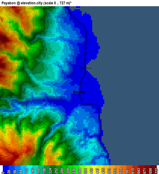
Below is the Elevation map of Payabon, which displays elevation range with different colors. Scale of the first map is from 0 to 727 m (0 to 2385 ft) with average elevation of 216.8 meters (=711 ft) [note 1]
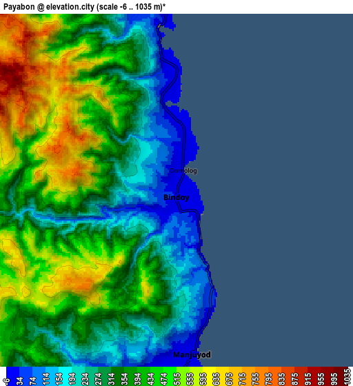
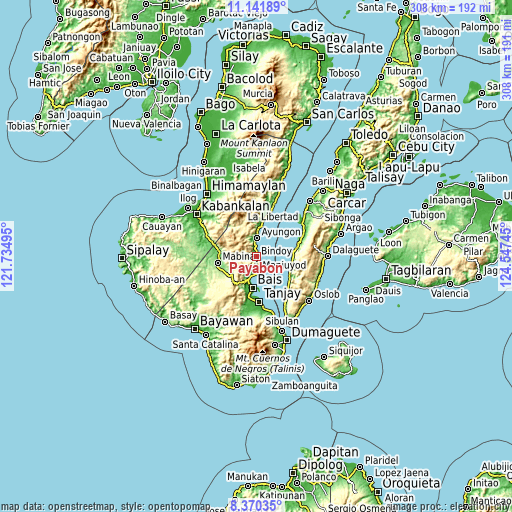
These maps also provides idea of topography and contour of this city, they are displayed at different zoom levels. More info about maps, scale and edge coordinates you can find below images.
| \ | Map #1 | Map #2 | Topo.Map |
| Scale [m] | 0..727 m | -6..1035 m | × |
| Scale [ft] | 0..2385 ft | -20..3396 ft | × |
| Average | 216.8 m = 711 ft | 372 m = 1220 ft | × |
| Width | 9.63 km = 6 mi | 19.26 km = 12 mi | 308.2 km = 191.5 mi |
| Height | 9.63 km = 6 mi | 19.26 km = 12 mi | 308.2 km = 191.5 mi |
| ↑Max Latitude | 9.802307° | 9.845608° | 11.14189° |
| Latitude at center | 9.759° | 9.759° | 9.759° |
| ↓Min Latitude | 9.715688° | 9.67237° | 8.37035° |
| ← Min Longitude | 123.097255° | 123.053309° | 121.73495° |
| Longitude center | 123.1412° | 123.1412° | 123.1412° |
| →Max Longitude | 123.185145° | 123.229091° | 124.54745° |
Nearby cities:
Cities around Payabon sort by population:
• Nalundan elevation 166 m
8.2 km,  263°
263°
• Tampocon 48 m
10.2 km,  355°
355°
• Tamiso 76 m
15.4 km,  202°
202°
• Bolisong 42 m
7.6 km,  171°
171°
• Campoyo 11 m
11.4 km,  176°
176°
• Tiguib 8 m
4.7 km,  351°
351°
• Kandabong 358 m
11.1 km,  222°
222°
• Alangilanan 14 m
13.6 km, 196°
• Tinaogan 11 m
2.4 km,  24°
24°
• Amdos 478 m
14.5 km,  340°
340°
• Bulod 12 m
8.5 km, 173°
• Ayungon 7 m
11.1 km,  1°
1°
Multilingual:
 En español:
Payabon elevación 19 m.
 En France:
Payabon élévation 19 m.


Sources and notes:
- [note 1] Map square and city borders are not equal. Map elevation data is calculated only from area inside that square.
- [src 1] Elevation data from geonames database provided with same terms of usage.
- [src 2] The elevation map of Payabon is generated using elevation data from NASA's 3 arcsec (90m) resolution SRTM data.
- [src 3] Base (background) map © OpenStreetMap contributors tiles are generated by Geofabrik and OpenTopoMap.
Copyright & License:
This Payabon Elevation Map is licensed under CC BY-SA. You may reuse any part from this page, if you give a proper credit by linking to this URL:
 More info on terms of use page.