Bolong elevation
Bolong (Zamboanga Peninsula, Province of Zamboanga del Sur), Philippines elevation is 6 meters and Bolong elevation in feet is 20 ft above sea level [src 1]. Bolong is a populated place (feature code) with elevation that is 82 meters (269 ft) smaller than average city elevation in Philippines.
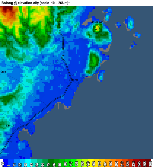
Below is the Elevation map of Bolong, which displays elevation range with different colors. Scale of the first map is from -10 to 266 m (-33 to 873 ft) with average elevation of 42.9 meters (=141 ft) [note 1]
These maps also provides idea of topography and contour of this city, they are displayed at different zoom levels. More info about maps, scale and edge coordinates you can find below images.
| \ | Map #1 | Map #2 | Topo.Map |
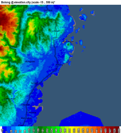
| Scale [m] | -10..266 m | -15..550 m | × |
| Scale [ft] | -33..873 ft | -49..1804 ft | × |
| Average | 42.9 m = 141 ft | 114.2 m = 375 ft | × |
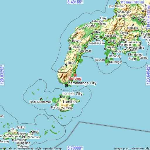
| Width | 9.7 km = 6 mi | 19.4 km = 12.1 mi | 310.3 km = 192.8 mi |
| Height | 9.7 km = 6 mi | 19.4 km = 12.1 mi | 310.3 km = 192.8 mi |
| ↑Max Latitude | 7.141936° | 7.185539° | 8.49155° |
| Latitude at center | 7.09833° | 7.09833° | 7.09833° |
| ↓Min Latitude | 7.054719° | 7.011105° | 5.70088° |
| ← Min Longitude | 122.195225° | 122.151279° | 120.83292° |
| Longitude center | 122.23917° | 122.23917° | 122.23917° |
| →Max Longitude | 122.283115° | 122.327061° | 123.64542° |
Nearby cities:
Cities around Bolong sort by population:
• Sangali elevation 8 m
5.3 km,  232°
232°
• Manicahan 8 m
9.7 km,  205°
205°
• Curuan 15 m
11.9 km,  356°
356°
• Bunguiao 24 m
4.8 km,  278°
278°
• Buenavista 49 m
15.4 km,  6°
6°
• Cabaluay 7 m
12.6 km, 211°
• Landang Laum 24 m
14.4 km,  175°
175°
• Quinipot 11 m
9.3 km,  347°
347°
• Lamisahan 85 m
9.4 km,  251°
251°
• Dulian 57 m
7.1 km,  291°
291°
• Tolosa 108 m
11.3 km, 229°
• Calabasa 184 m
16.5 km, 358°
Multilingual:
 En español:
Bolong elevación 6 m.
 En France:
Bolong élévation 6 m.


Sources and notes:
- [note 1] Map square and city borders are not equal. Map elevation data is calculated only from area inside that square.
- [src 1] Elevation data from geonames database provided with same terms of usage.
- [src 2] The elevation map of Bolong is generated using elevation data from NASA's 3 arcsec (90m) resolution SRTM data.
- [src 3] Base (background) map © OpenStreetMap contributors tiles are generated by Geofabrik and OpenTopoMap.
Copyright & License:
This Bolong Elevation Map is licensed under CC BY-SA. You may reuse any part from this page, if you give a proper credit by linking to this URL:
 More info on terms of use page.