Bungsuan elevation
Bungsuan (Western Visayas, Province of Capiz), Philippines elevation is 36 meters and Bungsuan elevation in feet is 118 ft above sea level [src 1]. Bungsuan is a populated place (feature code) with elevation that is 52 meters (171 ft) smaller than average city elevation in Philippines.
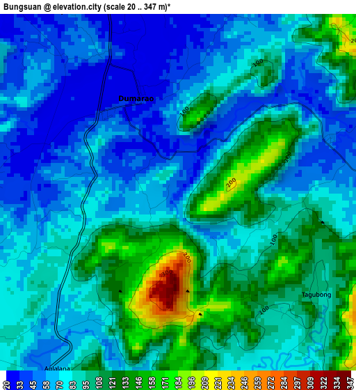
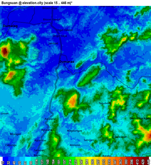
Below is the Elevation map of Bungsuan, which displays elevation range with different colors. Scale of the first map is from 20 to 347 m (66 to 1138 ft) with average elevation of 86.3 meters (=283 ft) [note 1]
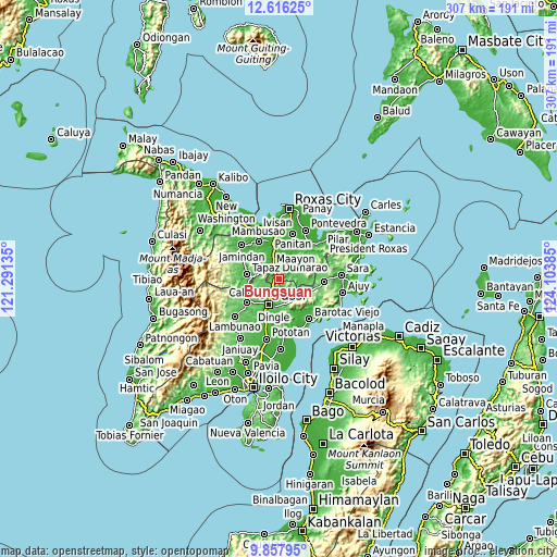
These maps also provides idea of topography and contour of this city, they are displayed at different zoom levels. More info about maps, scale and edge coordinates you can find below images.
| \ | Map #1 | Map #2 | Topo.Map |
| Scale [m] | 20..347 m | 15..446 m | × |
| Scale [ft] | 66..1138 ft | 49..1463 ft | × |
| Average | 86.3 m = 283 ft | 91.1 m = 299 ft | × |
| Width | 9.58 km = 6 mi | 19.17 km = 11.9 mi | 306.7 km = 190.6 mi |
| Height | 9.59 km = 6 mi | 19.17 km = 11.9 mi | 306.7 km = 190.6 mi |
| ↑Max Latitude | 11.283499° | 11.326592° | 12.61625° |
| Latitude at center | 11.2404° | 11.2404° | 11.2404° |
| ↓Min Latitude | 11.197294° | 11.154182° | 9.85795° |
| ← Min Longitude | 122.653655° | 122.609709° | 121.29135° |
| Longitude center | 122.6976° | 122.6976° | 122.6976° |
| →Max Longitude | 122.741545° | 122.785491° | 124.10385° |
Nearby cities:
Cities around Bungsuan sort by population:
• Cuartero elevation 22 m
11.6 km,  344°
344°
• Dumarao 27 m
2.9 km, 341°
• Duran 43 m
11.8 km,  281°
281°
• Dumalag 28 m
11 km,  312°
312°
• Aglalana 64 m
8 km,  213°
213°
• Alimono 81 m
6.3 km,  164°
164°
• Asturga 71 m
11.5 km,  82°
82°
• Jaguimitan 74 m
11.5 km,  165°
165°
• Gibato 61 m
12.8 km,  97°
97°
• Santa Angel 25 m
9.6 km,  320°
320°
• Abaca 69 m
12 km, 170°
• Consolacion 38 m
12 km, 324°
Multilingual:
 En español:
Bungsuan elevación 36 m.
 En France:
Bungsuan élévation 36 m.


Sources and notes:
- [note 1] Map square and city borders are not equal. Map elevation data is calculated only from area inside that square.
- [src 1] Elevation data from geonames database provided with same terms of usage.
- [src 2] The elevation map of Bungsuan is generated using elevation data from NASA's 3 arcsec (90m) resolution SRTM data.
- [src 3] Base (background) map © OpenStreetMap contributors tiles are generated by Geofabrik and OpenTopoMap.
Copyright & License:
This Bungsuan Elevation Map is licensed under CC BY-SA. You may reuse any part from this page, if you give a proper credit by linking to this URL:
 More info on terms of use page.