Buenavista elevation
Buenavista (Western Visayas, Province of Guimaras), Philippines elevation is 68 meters and Buenavista elevation in feet is 223 ft above sea level [src 1]. Buenavista is a seat of a third-order administrative division (feature code) with elevation that is 20 meters (66 ft) smaller than average city elevation in Philippines.
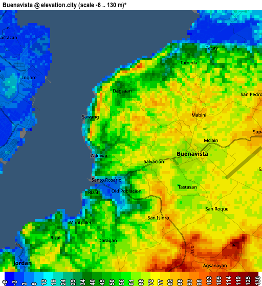
Below is the Elevation map of Buenavista, which displays elevation range with different colors. Scale of the first map is from -8 to 130 m (-26 to 427 ft) with average elevation of 55.4 meters (=182 ft) [note 1]
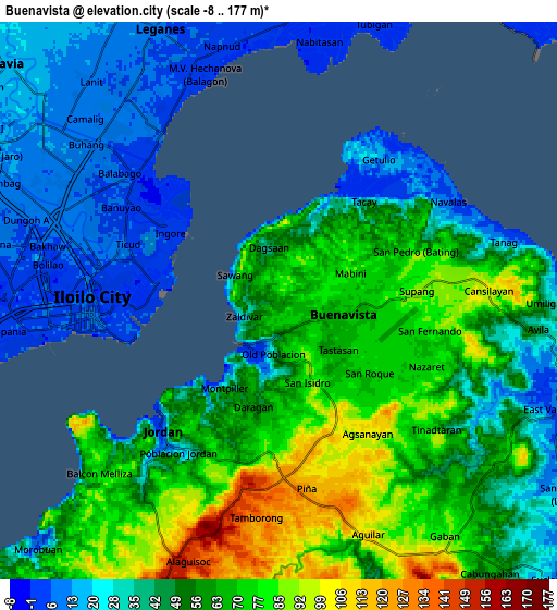
These maps also provides idea of topography and contour of this city, they are displayed at different zoom levels. More info about maps, scale and edge coordinates you can find below images.
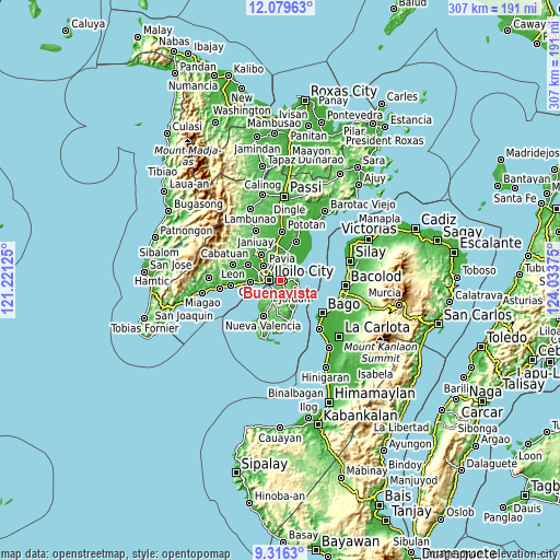
| \ | Map #1 | Map #2 | Topo.Map |
| Scale [m] | -8..130 m | -8..177 m | × |
| Scale [ft] | -26..427 ft | -26..581 ft | × |
| Average | 55.4 m = 182 ft | 51.2 m = 168 ft | × |
| Width | 9.6 km = 6 mi | 19.21 km = 11.9 mi | 307.3 km = 190.9 mi |
| Height | 9.6 km = 6 mi | 19.21 km = 11.9 mi | 307.3 km = 190.9 mi |
| ↑Max Latitude | 10.744288° | 10.78746° | 12.07963° |
| Latitude at center | 10.70111° | 10.70111° | 10.70111° |
| ↓Min Latitude | 10.657926° | 10.614736° | 9.3163° |
| ← Min Longitude | 122.583555° | 122.539609° | 121.22125° |
| Longitude center | 122.6275° | 122.6275° | 122.6275° |
| →Max Longitude | 122.671445° | 122.715391° | 124.03375° |
Nearby cities:
Cities around Buenavista sort by population:
• Iloilo elevation 8 m
6.9 km,  266°
266°
• Jordan 54 m
5.8 km,  215°
215°
• Ungca 10 m
10.1 km,  302°
302°
• Salvacion 19 m
2.3 km,  210°
210°
• Leganes 9 m
10.5 km,  336°
336°
• East Valencia 10 m
9.7 km,  112°
112°
• Rizal 75 m
2.1 km,  162°
162°
• Avila 48 m
9 km,  96°
96°
• Tigum 14 m
11.3 km,  323°
323°
• Getulio 16 m
6.6 km,  39°
39°
• Piña 125 m
6.9 km,  170°
170°
• San Enrique 10 m
11.1 km,  118°
118°
Multilingual:
 En español:
Buenavista elevación 68 m.
 En France:
Buenavista élévation 68 m.
 Auf Deutsch:
Buenavista höhe über dem Meeresspiegel ist 68 m.

Sources and notes:
- [note 1] Map square and city borders are not equal. Map elevation data is calculated only from area inside that square.
- [src 1] Elevation data from geonames database provided with same terms of usage.
- [src 2] The elevation map of Buenavista is generated using elevation data from NASA's 3 arcsec (90m) resolution SRTM data.
- [src 3] Base (background) map © OpenStreetMap contributors tiles are generated by Geofabrik and OpenTopoMap.
Copyright & License:
This Buenavista Elevation Map is licensed under CC BY-SA. You may reuse any part from this page, if you give a proper credit by linking to this URL:
 More info on terms of use page.