Bungoy elevation
Bungoy (Calabarzon, Province of Quezon), Philippines elevation is 101 meters and Bungoy elevation in feet is 331 ft above sea level [src 1]. Bungoy is a populated place (feature code) with elevation that is 13 meters (43 ft) bigger than average city elevation in Philippines.
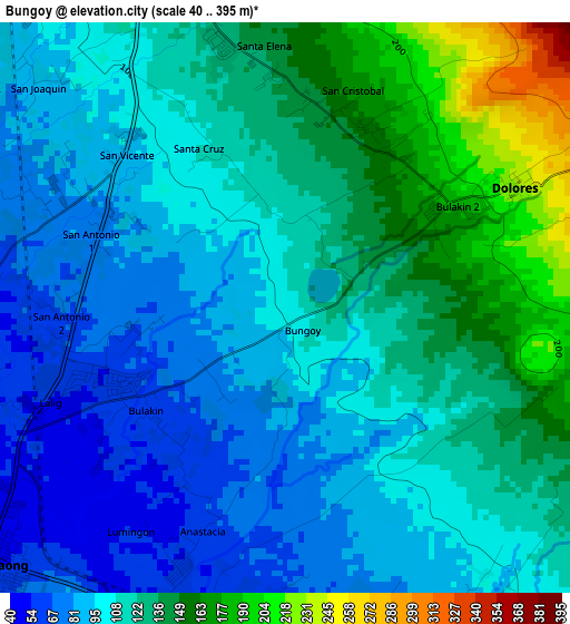
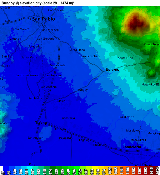
Below is the Elevation map of Bungoy, which displays elevation range with different colors. Scale of the first map is from 40 to 395 m (131 to 1296 ft) with average elevation of 115.2 meters (=378 ft) [note 1]
These maps also provides idea of topography and contour of this city, they are displayed at different zoom levels. More info about maps, scale and edge coordinates you can find below images.
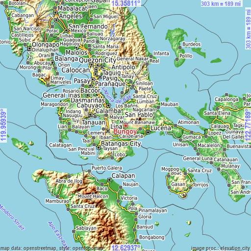
| \ | Map #1 | Map #2 | Topo.Map |
| Scale [m] | 40..395 m | 29..1474 m | × |
| Scale [ft] | 131..1296 ft | 95..4836 ft | × |
| Average | 115.2 m = 378 ft | 181.6 m = 596 ft | × |
| Width | 9.48 km = 5.9 mi | 18.96 km = 11.8 mi | 303.4 km = 188.5 mi |
| Height | 9.48 km = 5.9 mi | 18.96 km = 11.8 mi | 303.4 km = 188.5 mi |
| ↑Max Latitude | 14.040426° | 14.083055° | 15.35811° |
| Latitude at center | 13.99779° | 13.99779° | 13.99779° |
| ↓Min Latitude | 13.955146° | 13.912493° | 12.62937° |
| ← Min Longitude | 121.321695° | 121.277749° | 119.95939° |
| Longitude center | 121.36564° | 121.36564° | 121.36564° |
| →Max Longitude | 121.409585° | 121.453531° | 122.77189° |
Nearby cities:
Cities around Bungoy sort by population:
• Lusacan elevation 52 m
5.2 km,  205°
205°
• Lalig 51 m
4.6 km,  248°
248°
• Masalukot Uno 113 m
7.4 km,  129°
129°
• Dolores 291 m
5.5 km,  60°
60°
• Tiaong 47 m
6.1 km,  231°
231°
• Cabatang 74 m
3.4 km,  177°
177°
• Santisimo Rosario 57 m
6.1 km,  268°
268°
• Ayusan Uno 56 m
7.8 km, 233°
• Quipot 52 m
6.9 km, 226°
• Dagatan 133 m
1.3 km,  69°
69°
• Bukal Sur 67 m
7 km,  162°
162°
• Santa Cruz 115 m
2.7 km,  340°
340°
Multilingual:
 En español:
Bungoy elevación 101 m.
 En France:
Bungoy élévation 101 m.


Sources and notes:
- [note 1] Map square and city borders are not equal. Map elevation data is calculated only from area inside that square.
- [src 1] Elevation data from geonames database provided with same terms of usage.
- [src 2] The elevation map of Bungoy is generated using elevation data from NASA's 3 arcsec (90m) resolution SRTM data.
- [src 3] Base (background) map © OpenStreetMap contributors tiles are generated by Geofabrik and OpenTopoMap.
Copyright & License:
This Bungoy Elevation Map is licensed under CC BY-SA. You may reuse any part from this page, if you give a proper credit by linking to this URL:
 More info on terms of use page.