Cagsiay elevation
Cagsiay (Calabarzon, Province of Quezon), Philippines elevation is 26 meters and Cagsiay elevation in feet is 85 ft above sea level [src 1]. Cagsiay is a populated place (feature code) with elevation that is 62 meters (203 ft) smaller than average city elevation in Philippines.
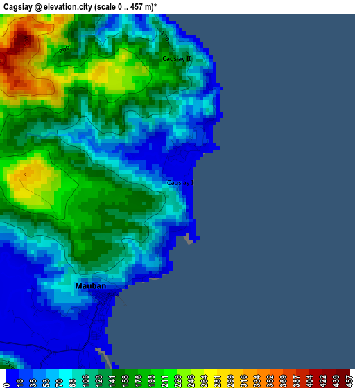
Below is the Elevation map of Cagsiay, which displays elevation range with different colors. Scale of the first map is from 0 to 457 m (0 to 1499 ft) with average elevation of 122.5 meters (=402 ft) [note 1]
These maps also provides idea of topography and contour of this city, they are displayed at different zoom levels. More info about maps, scale and edge coordinates you can find below images.
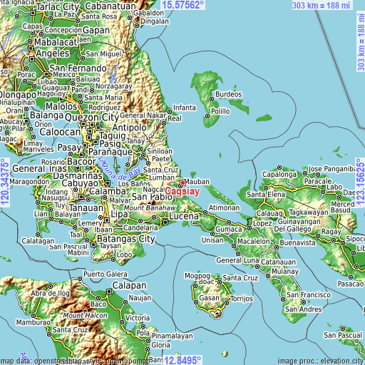
| \ | Map #1 | Map #2 | Topo.Map |
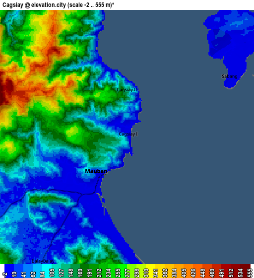
| Scale [m] | 0..457 m | -2..555 m | × |
| Scale [ft] | 0..1499 ft | -7..1821 ft | × |
| Average | 122.5 m = 402 ft | 143.5 m = 471 ft | × |
| Width | 9.47 km = 5.9 mi | 18.95 km = 11.8 mi | 303.1 km = 188.3 mi |
| Height | 9.47 km = 5.9 mi | 18.95 km = 11.8 mi | 303.1 km = 188.3 mi |
| ↑Max Latitude | 14.259265° | 14.301853° | 15.57562° |
| Latitude at center | 14.21667° | 14.21667° | 14.21667° |
| ↓Min Latitude | 14.174067° | 14.131455° | 12.8495° |
| ← Min Longitude | 121.706055° | 121.662109° | 120.34375° |
| Longitude center | 121.75° | 121.75° | 121.75° |
| →Max Longitude | 121.793945° | 121.837891° | 123.15625° |
Nearby cities:
Cities around Cagsiay sort by population:
• Mauban elevation 7 m
3.5 km,  215°
215°
• Lucban 431 m
23.9 km,  241°
241°
• Cavinti 219 m
26.3 km,  276°
276°
• Malinao Ilaya 27 m
26.2 km,  159°
159°
• Kalayaan 391 m
24.7 km,  306°
306°
• Sampaloc 68 m
13.3 km, 243°
• Malicboy 12 m
26.5 km,  170°
170°
• Binahaan 19 m
25 km,  179°
179°
• Perez 13 m
19.2 km,  97°
97°
• Luisiana 387 m
26 km,  262°
262°
• San Antonio 384 m
27 km,  266°
266°
• Mainit Norte 68 m
26 km, 102°
Multilingual:
 En español:
Cagsiay elevación 26 m.
 En France:
Cagsiay élévation 26 m.


Sources and notes:
- [note 1] Map square and city borders are not equal. Map elevation data is calculated only from area inside that square.
- [src 1] Elevation data from geonames database provided with same terms of usage.
- [src 2] The elevation map of Cagsiay is generated using elevation data from NASA's 3 arcsec (90m) resolution SRTM data.
- [src 3] Base (background) map © OpenStreetMap contributors tiles are generated by Geofabrik and OpenTopoMap.
Copyright & License:
This Cagsiay Elevation Map is licensed under CC BY-SA. You may reuse any part from this page, if you give a proper credit by linking to this URL:
 More info on terms of use page.