Candon elevation
Candon (Ilocos, Province of Ilocos Sur), Philippines elevation is 10 meters and Candon elevation in feet is 33 ft above sea level [src 1]. Candon is a seat of a third-order administrative division (feature code) with elevation that is 78 meters (256 ft) smaller than average city elevation in Philippines.
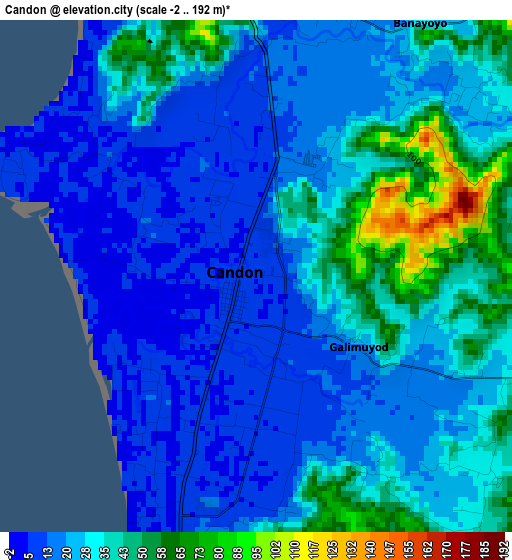
Below is the Elevation map of Candon, which displays elevation range with different colors. Scale of the first map is from -2 to 192 m (-7 to 630 ft) with average elevation of 27.2 meters (=89 ft) [note 1]
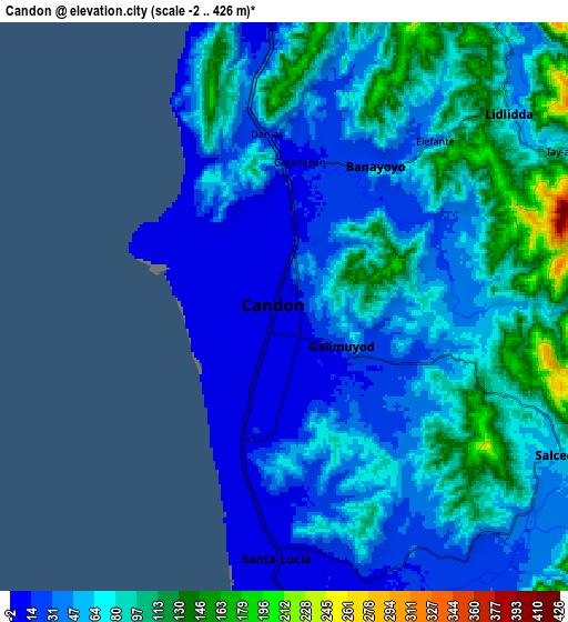
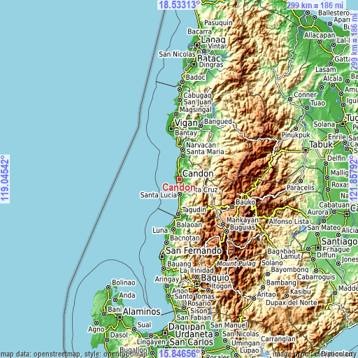
These maps also provides idea of topography and contour of this city, they are displayed at different zoom levels. More info about maps, scale and edge coordinates you can find below images.
| \ | Map #1 | Map #2 | Topo.Map |
| Scale [m] | -2..192 m | -2..426 m | × |
| Scale [ft] | -7..630 ft | -7..1398 ft | × |
| Average | 27.2 m = 89 ft | 62.7 m = 206 ft | × |
| Width | 9.34 km = 5.8 mi | 18.67 km = 11.6 mi | 298.7 km = 185.6 mi |
| Height | 9.34 km = 5.8 mi | 18.67 km = 11.6 mi | 298.7 km = 185.6 mi |
| ↑Max Latitude | 17.236696° | 17.278663° | 18.53313° |
| Latitude at center | 17.19472° | 17.19472° | 17.19472° |
| ↓Min Latitude | 17.152734° | 17.110739° | 15.84656° |
| ← Min Longitude | 120.407725° | 120.363779° | 119.04542° |
| Longitude center | 120.45167° | 120.45167° | 120.45167° |
| →Max Longitude | 120.495615° | 120.539561° | 121.85792° |
Nearby cities:
Cities around Candon sort by population:
• Tablac elevation 10 m
2.3 km,  6°
6°
• Parioc Segundo 11 m
2.7 km,  145°
145°
• Darapidap 8 m
3.6 km,  279°
279°
• Santa Lucia 7 m
8.6 km,  179°
179°
• Patpata Segundo 5 m
2.3 km,  236°
236°
• Calongbuyan 5 m
4.2 km,  218°
218°
• Allangigan Primero 27 m
4.9 km,  118°
118°
• Caterman 5 m
3.8 km,  311°
311°
• Lidlidda 47 m
11.1 km,  41°
41°
• Salcedo 88 m
10.3 km, 115°
• Banayoyo 50 m
5.5 km, 38°
• Galimuyod 44 m
2.4 km, 117°
Multilingual:
 En español:
Candon elevación 10 m.
 En France:
Candon élévation 10 m.


Sources and notes:
- [note 1] Map square and city borders are not equal. Map elevation data is calculated only from area inside that square.
- [src 1] Elevation data from geonames database provided with same terms of usage.
- [src 2] The elevation map of Candon is generated using elevation data from NASA's 3 arcsec (90m) resolution SRTM data.
- [src 3] Base (background) map © OpenStreetMap contributors tiles are generated by Geofabrik and OpenTopoMap.
Copyright & License:
This Candon Elevation Map is licensed under CC BY-SA. You may reuse any part from this page, if you give a proper credit by linking to this URL:
 More info on terms of use page.