Cogan elevation
Cogan (Central Visayas, Province of Cebu), Philippines elevation is 13 meters and Cogan elevation in feet is 43 ft above sea level [src 1]. Cogan is a populated place (feature code) with elevation that is 75 meters (246 ft) smaller than average city elevation in Philippines.
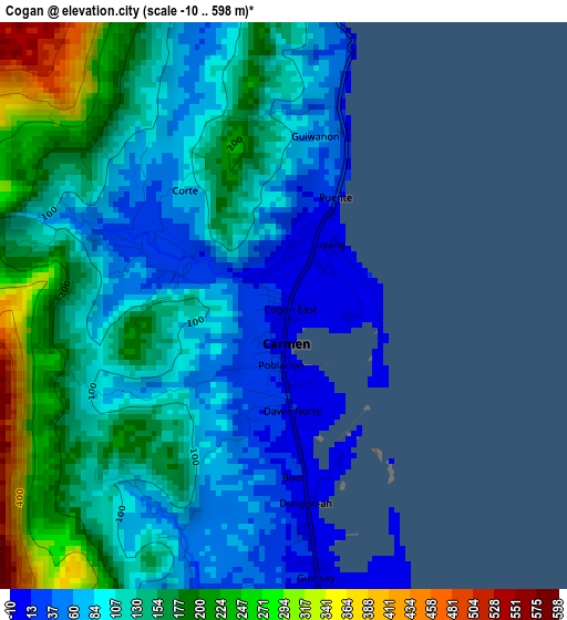
Below is the Elevation map of Cogan, which displays elevation range with different colors. Scale of the first map is from -10 to 598 m (-33 to 1962 ft) with average elevation of 128 meters (=420 ft) [note 1]
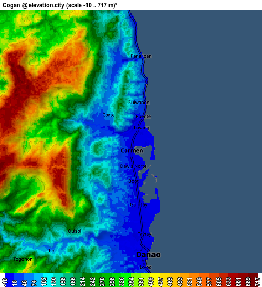
These maps also provides idea of topography and contour of this city, they are displayed at different zoom levels. More info about maps, scale and edge coordinates you can find below images.
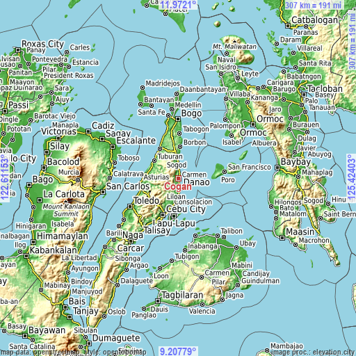
| \ | Map #1 | Map #2 | Topo.Map |
| Scale [m] | -10..598 m | -10..717 m | × |
| Scale [ft] | -33..1962 ft | -33..2352 ft | × |
| Average | 128 m = 420 ft | 259.6 m = 852 ft | × |
| Width | 9.61 km = 6 mi | 19.21 km = 11.9 mi | 307.4 km = 191 mi |
| Height | 9.61 km = 6 mi | 19.21 km = 11.9 mi | 307.4 km = 191 mi |
| ↑Max Latitude | 10.636253° | 10.679441° | 11.9721° |
| Latitude at center | 10.59306° | 10.59306° | 10.59306° |
| ↓Min Latitude | 10.549861° | 10.506655° | 9.20779° |
| ← Min Longitude | 123.973835° | 123.929889° | 122.61153° |
| Longitude center | 124.01778° | 124.01778° | 124.01778° |
| →Max Longitude | 124.061725° | 124.105671° | 125.42403° |
Nearby cities:
Cities around Cogan sort by population:
• Danao elevation 7 m
8.1 km,  172°
172°
• Catmon 85 m
13.9 km,  351°
351°
• Nangka 404 m
7.4 km,  229°
229°
• Sandayong Sur 75 m
11 km,  190°
190°
• Cogon Cruz 260 m
10.7 km,  209°
209°
• Catmondaan 20 m
10.4 km,  358°
358°
• Macaas 8 m
11.8 km, 356°
• Panalipan 60 m
6.2 km,  3°
3°
• Cambanay 225 m
6.5 km, 212°
• Masaba 150 m
8.7 km,  220°
220°
• Kabungahan 258 m
9.3 km,  203°
203°
• Magay 7 m
13.5 km,  182°
182°
Multilingual:
 En español:
Cogan elevación 13 m.
 En France:
Cogan élévation 13 m.


Sources and notes:
- [note 1] Map square and city borders are not equal. Map elevation data is calculated only from area inside that square.
- [src 1] Elevation data from geonames database provided with same terms of usage.
- [src 2] The elevation map of Cogan is generated using elevation data from NASA's 3 arcsec (90m) resolution SRTM data.
- [src 3] Base (background) map © OpenStreetMap contributors tiles are generated by Geofabrik and OpenTopoMap.
Copyright & License:
This Cogan Elevation Map is licensed under CC BY-SA. You may reuse any part from this page, if you give a proper credit by linking to this URL:
 More info on terms of use page.