Casiguran elevation
Casiguran (Bicol, Province of Sorsogon), Philippines elevation is 12 meters and Casiguran elevation in feet is 39 ft above sea level [src 1]. Casiguran is a seat of a third-order administrative division (feature code) with elevation that is 76 meters (249 ft) smaller than average city elevation in Philippines.
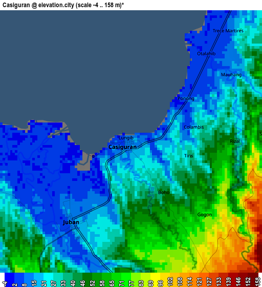
Below is the Elevation map of Casiguran, which displays elevation range with different colors. Scale of the first map is from -4 to 158 m (-13 to 518 ft) with average elevation of 37.1 meters (=122 ft) [note 1]
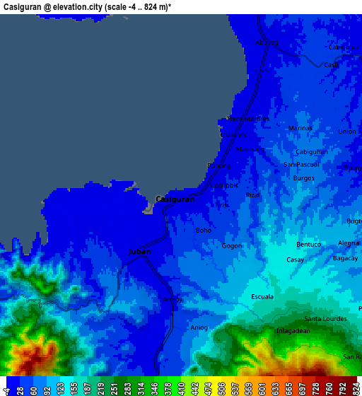
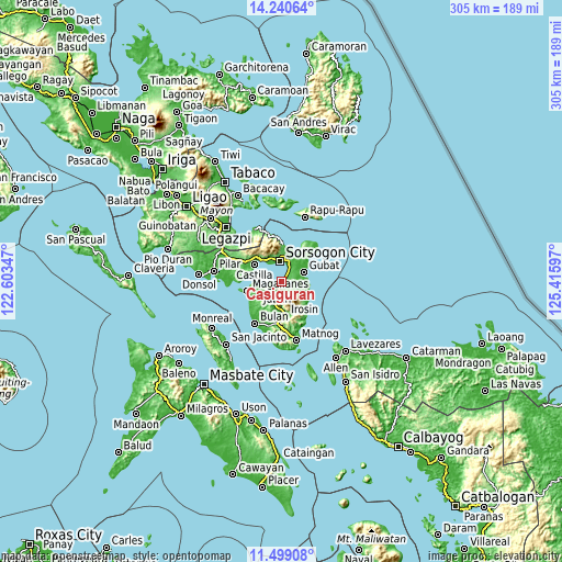
These maps also provides idea of topography and contour of this city, they are displayed at different zoom levels. More info about maps, scale and edge coordinates you can find below images.
| \ | Map #1 | Map #2 | Topo.Map |
| Scale [m] | -4..158 m | -4..824 m | × |
| Scale [ft] | -13..518 ft | -13..2703 ft | × |
| Average | 37.1 m = 122 ft | 107.6 m = 353 ft | × |
| Width | 9.53 km = 5.9 mi | 19.05 km = 11.8 mi | 304.8 km = 189.4 mi |
| Height | 9.53 km = 5.9 mi | 19.05 km = 11.8 mi | 304.9 km = 189.5 mi |
| ↑Max Latitude | 12.916447° | 12.959277° | 14.24064° |
| Latitude at center | 12.87361° | 12.87361° | 12.87361° |
| ↓Min Latitude | 12.830766° | 12.787914° | 11.49908° |
| ← Min Longitude | 123.965775° | 123.921829° | 122.60347° |
| Longitude center | 124.00972° | 124.00972° | 124.00972° |
| →Max Longitude | 124.053665° | 124.097611° | 125.41597° |
Nearby cities:
Cities around Casiguran sort by population:
• Sorsogon elevation 13 m
11.3 km,  350°
350°
• Gubat 7 m
13.3 km,  66°
66°
• Juban 4 m
3.7 km,  219°
219°
• Abuyog 7 m
9.3 km,  29°
29°
• Barcelona 8 m
14.3 km,  92°
92°
• Rizal 8 m
13.6 km,  83°
83°
• Buhatan 9 m
12.1 km,  20°
20°
• Gabao 35 m
13.2 km,  3°
3°
• Boton 7 m
7.4 km, 34°
• Lajong 30 m
6.5 km,  226°
226°
• Carriedo 15 m
12.3 km,  56°
56°
• Santa Cruz 43 m
5.1 km, 86°
Multilingual:
 En español:
Casiguran elevación 12 m.
 En France:
Casiguran élévation 12 m.
 Auf Deutsch:
Casiguran höhe über dem Meeresspiegel ist 12 m.

Sources and notes:
- [note 1] Map square and city borders are not equal. Map elevation data is calculated only from area inside that square.
- [src 1] Elevation data from geonames database provided with same terms of usage.
- [src 2] The elevation map of Casiguran is generated using elevation data from NASA's 3 arcsec (90m) resolution SRTM data.
- [src 3] Base (background) map © OpenStreetMap contributors tiles are generated by Geofabrik and OpenTopoMap.
Copyright & License:
This Casiguran Elevation Map is licensed under CC BY-SA. You may reuse any part from this page, if you give a proper credit by linking to this URL:
 More info on terms of use page.