Cataingan elevation
Cataingan (Bicol, Province of Masbate), Philippines elevation is 54 meters and Cataingan elevation in feet is 177 ft above sea level [src 1]. Cataingan is a populated place (feature code) with elevation that is 34 meters (112 ft) smaller than average city elevation in Philippines.
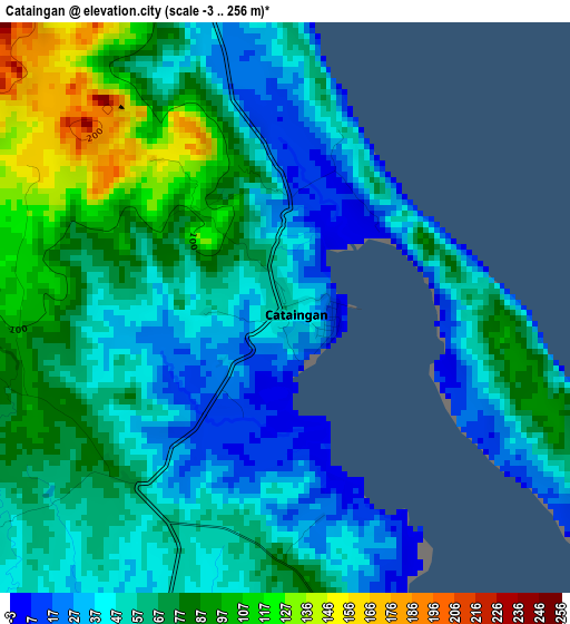
Below is the Elevation map of Cataingan, which displays elevation range with different colors. Scale of the first map is from -3 to 256 m (-10 to 840 ft) with average elevation of 62.6 meters (=205 ft) [note 1]
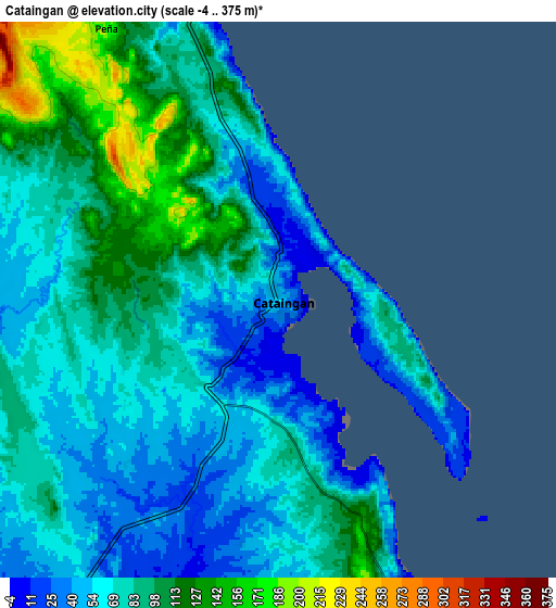
These maps also provides idea of topography and contour of this city, they are displayed at different zoom levels. More info about maps, scale and edge coordinates you can find below images.
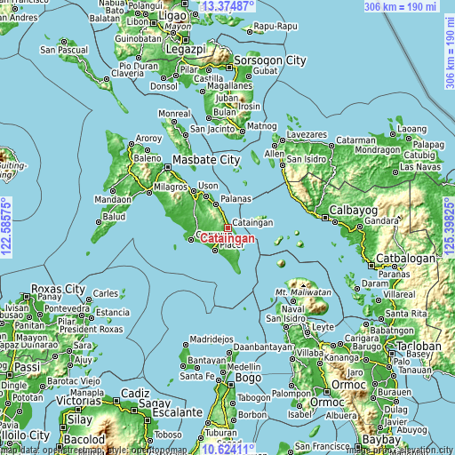
| \ | Map #1 | Map #2 | Topo.Map |
| Scale [m] | -3..256 m | -4..375 m | × |
| Scale [ft] | -10..840 ft | -13..1230 ft | × |
| Average | 62.6 m = 205 ft | 78.3 m = 257 ft | × |
| Width | 9.56 km = 5.9 mi | 19.12 km = 11.9 mi | 305.9 km = 190.1 mi |
| Height | 9.56 km = 5.9 mi | 19.12 km = 11.9 mi | 305.9 km = 190.1 mi |
| ↑Max Latitude | 12.045981° | 12.088955° | 13.37487° |
| Latitude at center | 12.003° | 12.003° | 12.003° |
| ↓Min Latitude | 11.960012° | 11.917017° | 10.62411° |
| ← Min Longitude | 123.948055° | 123.904109° | 122.58575° |
| Longitude center | 123.992° | 123.992° | 123.992° |
| →Max Longitude | 124.035945° | 124.079891° | 125.39825° |
Nearby cities:
Cities around Cataingan sort by population:
• Placer elevation 6 m
16.9 km,  208°
208°
• Limbuhan 4 m
14.7 km,  154°
154°
• Pawican 90 m
8.2 km,  343°
343°
• Buenavista 41 m
29.2 km,  311°
311°
• Dimasalang 7 m
25.5 km,  325°
325°
• Nabangig 99 m
11.6 km, 336°
• Palanas 9 m
17.6 km, 334°
• Peña 178 m
11.2 km, 328°
• San Pedro 7 m
1.8 km,  29°
29°
• Recodo 33 m
28.4 km,  257°
257°
• Balucawi 24 m
27.4 km,  323°
323°
• Tagapul-an 70 m
18 km,  73°
73°
Multilingual:
 En español:
Cataingan elevación 54 m.
 En France:
Cataingan élévation 54 m.
 Auf Deutsch:
Cataingan höhe über dem Meeresspiegel ist 54 m.

Sources and notes:
- [note 1] Map square and city borders are not equal. Map elevation data is calculated only from area inside that square.
- [src 1] Elevation data from geonames database provided with same terms of usage.
- [src 2] The elevation map of Cataingan is generated using elevation data from NASA's 3 arcsec (90m) resolution SRTM data.
- [src 3] Base (background) map © OpenStreetMap contributors tiles are generated by Geofabrik and OpenTopoMap.
Copyright & License:
This Cataingan Elevation Map is licensed under CC BY-SA. You may reuse any part from this page, if you give a proper credit by linking to this URL:
 More info on terms of use page.