Cawayan Bugtong elevation
Cawayan Bugtong (Central Luzon, Province of Nueva Ecija), Philippines elevation is 35 meters and Cawayan Bugtong elevation in feet is 115 ft above sea level [src 1]. Cawayan Bugtong is a populated place (feature code) with elevation that is 53 meters (174 ft) smaller than average city elevation in Philippines.
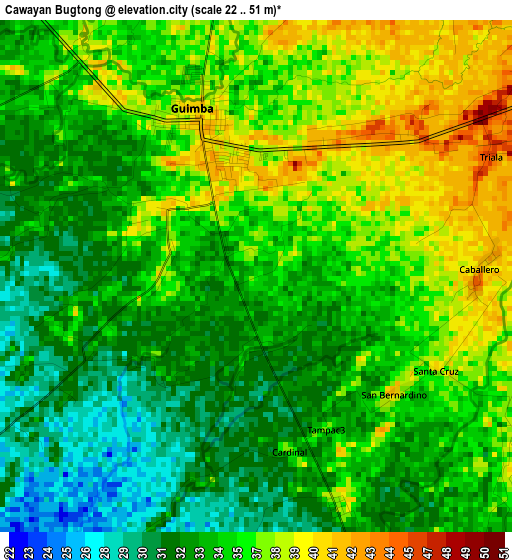
Below is the Elevation map of Cawayan Bugtong, which displays elevation range with different colors. Scale of the first map is from 22 to 51 m (72 to 167 ft) with average elevation of 34.7 meters (=114 ft) [note 1]
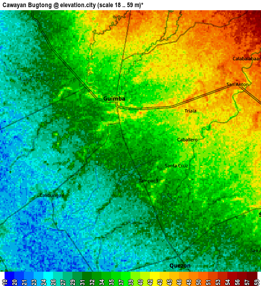
These maps also provides idea of topography and contour of this city, they are displayed at different zoom levels. More info about maps, scale and edge coordinates you can find below images.
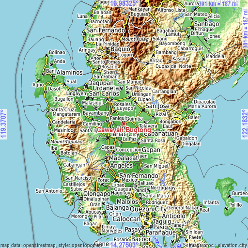
| \ | Map #1 | Map #2 | Topo.Map |
| Scale [m] | 22..51 m | 18..59 m | × |
| Scale [ft] | 72..167 ft | 59..194 ft | × |
| Average | 34.7 m = 114 ft | 34.4 m = 113 ft | × |
| Width | 9.41 km = 5.8 mi | 18.82 km = 11.7 mi | 301.1 km = 187.1 mi |
| Height | 9.41 km = 5.8 mi | 18.82 km = 11.7 mi | 301.1 km = 187.1 mi |
| ↑Max Latitude | 15.675935° | 15.718242° | 16.98325° |
| Latitude at center | 15.63362° | 15.63362° | 15.63362° |
| ↓Min Latitude | 15.591296° | 15.548963° | 14.27503° |
| ← Min Longitude | 120.733005° | 120.689059° | 119.3707° |
| Longitude center | 120.77695° | 120.77695° | 120.77695° |
| →Max Longitude | 120.820895° | 120.864841° | 122.1832° |
Nearby cities:
Cities around Cawayan Bugtong sort by population:
• Guimba elevation 38 m
3.1 km,  342°
342°
• Santo Rosario 49 m
9.1 km,  82°
82°
• Maturanoc 40 m
3.1 km,  31°
31°
• San Andres 53 m
9.5 km,  0°
0°
• San Cristobal 26 m
8.9 km,  186°
186°
• Lennec 37 m
7.2 km,  320°
320°
• Nagpandayan 31 m
3.7 km, 193°
• Bunol 47 m
7.2 km,  58°
58°
• San Casimiro 28 m
9 km,  177°
177°
• Cavite 41 m
5 km,  351°
351°
• Manacsac 37 m
4.5 km,  160°
160°
• Calibungan 28 m
6.9 km,  235°
235°
Multilingual:
 En español:
Cawayan Bugtong elevación 35 m.
 En France:
Cawayan Bugtong élévation 35 m.
 Auf Deutsch:
Cawayan Bugtong höhe über dem Meeresspiegel ist 35 m.

Sources and notes:
- [note 1] Map square and city borders are not equal. Map elevation data is calculated only from area inside that square.
- [src 1] Elevation data from geonames database provided with same terms of usage.
- [src 2] The elevation map of Cawayan Bugtong is generated using elevation data from NASA's 3 arcsec (90m) resolution SRTM data.
- [src 3] Base (background) map © OpenStreetMap contributors tiles are generated by Geofabrik and OpenTopoMap.
Copyright & License:
This Cawayan Bugtong Elevation Map is licensed under CC BY-SA. You may reuse any part from this page, if you give a proper credit by linking to this URL:
 More info on terms of use page.