Espiritu elevation
Espiritu (Ilocos, Province of Ilocos Norte), Philippines elevation is 77 meters and Espiritu elevation in feet is 253 ft above sea level [src 1]. Espiritu is a seat of a third-order administrative division (feature code) with elevation that is 11 meters (36 ft) smaller than average city elevation in Philippines.
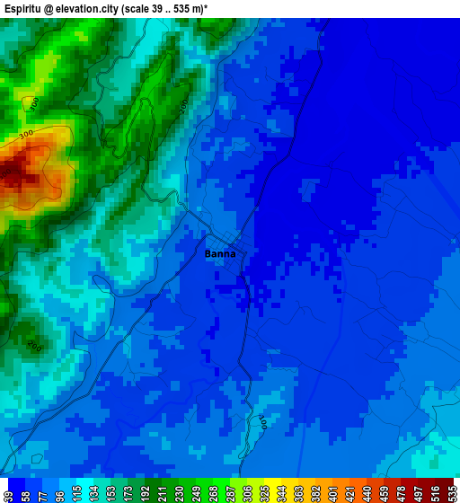
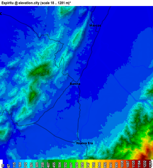
Below is the Elevation map of Espiritu, which displays elevation range with different colors. Scale of the first map is from 39 to 535 m (128 to 1755 ft) with average elevation of 108.6 meters (=356 ft) [note 1]
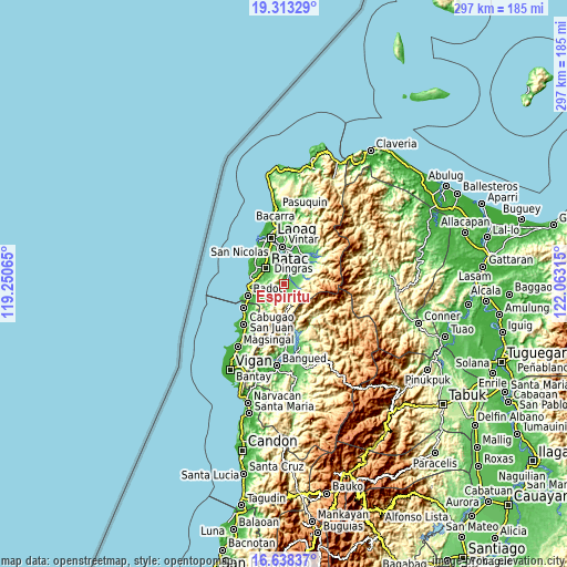
These maps also provides idea of topography and contour of this city, they are displayed at different zoom levels. More info about maps, scale and edge coordinates you can find below images.
| \ | Map #1 | Map #2 | Topo.Map |
| Scale [m] | 39..535 m | 18..1281 m | × |
| Scale [ft] | 128..1755 ft | 59..4203 ft | × |
| Average | 108.6 m = 356 ft | 144.7 m = 475 ft | × |
| Width | 9.3 km = 5.8 mi | 18.59 km = 11.6 mi | 297.4 km = 184.8 mi |
| Height | 9.3 km = 5.8 mi | 18.59 km = 11.6 mi | 297.4 km = 184.8 mi |
| ↑Max Latitude | 18.022694° | 18.064478° | 19.31329° |
| Latitude at center | 17.9809° | 17.9809° | 17.9809° |
| ↓Min Latitude | 17.939096° | 17.897282° | 16.63837° |
| ← Min Longitude | 120.612955° | 120.569009° | 119.25065° |
| Longitude center | 120.6569° | 120.6569° | 120.6569° |
| →Max Longitude | 120.700845° | 120.744791° | 122.06315° |
Nearby cities:
Cities around Espiritu sort by population:
• Batac City elevation 27 m
12.8 km,  310°
310°
• Dingras 29 m
14.2 km,  17°
17°
• Quiling 20 m
15.4 km, 309°
• Padong 49 m
13.1 km,  51°
51°
• Paoay 13 m
16.8 km,  302°
302°
• Tabug 48 m
12.9 km, 297°
• Barong 47 m
11.8 km,  43°
43°
• Pinili 45 m
14 km,  256°
256°
• Bil-Loca 20 m
15.1 km,  321°
321°
• San Lorenzo 22 m
17.1 km,  350°
350°
• Marcos 40 m
8.6 km, 23°
• Nueva Era 124 m
7.2 km,  173°
173°
Multilingual:
 En español:
Espiritu elevación 77 m.
 En France:
Espiritu élévation 77 m.


Sources and notes:
- [note 1] Map square and city borders are not equal. Map elevation data is calculated only from area inside that square.
- [src 1] Elevation data from geonames database provided with same terms of usage.
- [src 2] The elevation map of Espiritu is generated using elevation data from NASA's 3 arcsec (90m) resolution SRTM data.
- [src 3] Base (background) map © OpenStreetMap contributors tiles are generated by Geofabrik and OpenTopoMap.
Copyright & License:
This Espiritu Elevation Map is licensed under CC BY-SA. You may reuse any part from this page, if you give a proper credit by linking to this URL:
 More info on terms of use page.