Haguimit elevation
Haguimit (Western Visayas, Province of Negros Occidental), Philippines elevation is 187 meters and Haguimit elevation in feet is 614 ft above sea level [src 1]. Haguimit is a populated place (feature code) with elevation that is 99 meters (325 ft) bigger than average city elevation in Philippines.
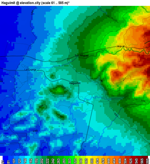
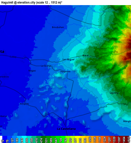
Below is the Elevation map of Haguimit, which displays elevation range with different colors. Scale of the first map is from 61 to 585 m (200 to 1919 ft) with average elevation of 194.7 meters (=639 ft) [note 1]
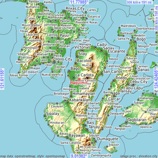
These maps also provides idea of topography and contour of this city, they are displayed at different zoom levels. More info about maps, scale and edge coordinates you can find below images.
| \ | Map #1 | Map #2 | Topo.Map |
| Scale [m] | 61..585 m | 12..1512 m | × |
| Scale [ft] | 200..1919 ft | 39..4961 ft | × |
| Average | 194.7 m = 639 ft | 219.4 m = 720 ft | × |
| Width | 9.61 km = 6 mi | 19.22 km = 11.9 mi | 307.6 km = 191.1 mi |
| Height | 9.61 km = 6 mi | 19.22 km = 11.9 mi | 307.6 km = 191.1 mi |
| ↑Max Latitude | 10.44312° | 10.486335° | 11.77985° |
| Latitude at center | 10.3999° | 10.3999° | 10.3999° |
| ↓Min Latitude | 10.356674° | 10.313441° | 9.01382° |
| ← Min Longitude | 122.973855° | 122.929909° | 121.61155° |
| Longitude center | 123.0178° | 123.0178° | 123.0178° |
| →Max Longitude | 123.061745° | 123.105691° | 124.42405° |
Nearby cities:
Cities around Haguimit sort by population:
• La Carlota elevation 27 m
10.9 km,  284°
284°
• Maao 59 m
10.4 km,  343°
343°
• La Castellana 67 m
8.5 km,  177°
177°
• Sagang 277 m
7.3 km,  125°
125°
• Antipolo 77 m
7.6 km,  230°
230°
• La Granja 117 m
3.2 km,  286°
286°
• Carmen Grande 16 m
11.4 km,  258°
258°
• Camandag 126 m
9.1 km,  144°
144°
• San Miguel 239 m
1.8 km,  12°
12°
• Lalagsan 38 m
13.1 km, 182°
• Araal 385 m
3.6 km,  52°
52°
• Yubo 387 m
5.7 km,  101°
101°
Multilingual:
 En español:
Haguimit elevación 187 m.
 En France:
Haguimit élévation 187 m.
 Auf Deutsch:
Haguimit höhe über dem Meeresspiegel ist 187 m.

Sources and notes:
- [note 1] Map square and city borders are not equal. Map elevation data is calculated only from area inside that square.
- [src 1] Elevation data from geonames database provided with same terms of usage.
- [src 2] The elevation map of Haguimit is generated using elevation data from NASA's 3 arcsec (90m) resolution SRTM data.
- [src 3] Base (background) map © OpenStreetMap contributors tiles are generated by Geofabrik and OpenTopoMap.
Copyright & License:
This Haguimit Elevation Map is licensed under CC BY-SA. You may reuse any part from this page, if you give a proper credit by linking to this URL:
 More info on terms of use page.