Hinatuan elevation
Hinatuan (Caraga, Province of Surigao del Sur), Philippines elevation is 7 meters and Hinatuan elevation in feet is 23 ft above sea level [src 1]. Hinatuan is a seat of a third-order administrative division (feature code) with elevation that is 81 meters (266 ft) smaller than average city elevation in Philippines.
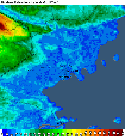
Below is the Elevation map of Hinatuan, which displays elevation range with different colors. Scale of the first map is from -6 to 147 m (-20 to 482 ft) with average elevation of 23.4 meters (=77 ft) [note 1]
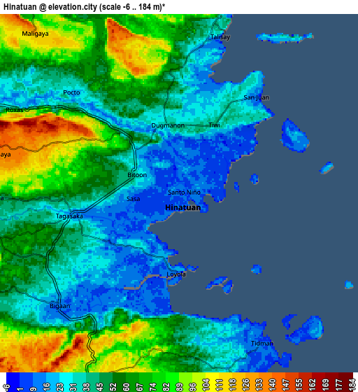
These maps also provides idea of topography and contour of this city, they are displayed at different zoom levels. More info about maps, scale and edge coordinates you can find below images.
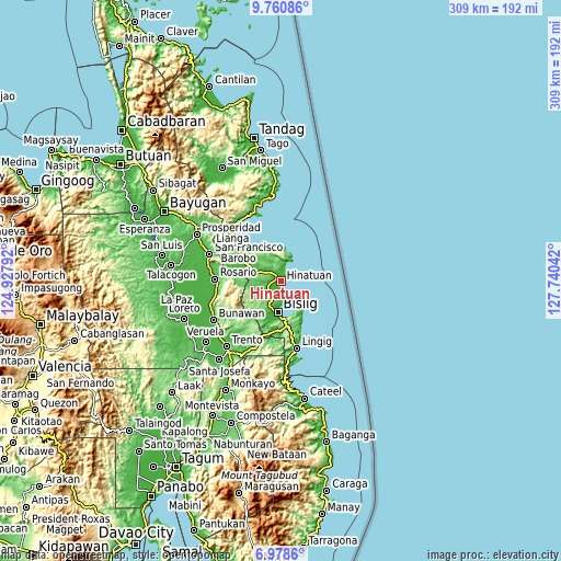
| \ | Map #1 | Map #2 | Topo.Map |
| Scale [m] | -6..147 m | -6..184 m | × |
| Scale [ft] | -20..482 ft | -20..604 ft | × |
| Average | 23.4 m = 77 ft | 52.3 m = 172 ft | × |
| Width | 9.67 km = 6 mi | 19.34 km = 12 mi | 309.4 km = 192.3 mi |
| Height | 9.67 km = 6 mi | 19.34 km = 12 mi | 309.4 km = 192.3 mi |
| ↑Max Latitude | 8.415695° | 8.459164° | 9.76086° |
| Latitude at center | 8.37222° | 8.37222° | 8.37222° |
| ↓Min Latitude | 8.328741° | 8.285256° | 6.9786° |
| ← Min Longitude | 126.290225° | 126.246279° | 124.92792° |
| Longitude center | 126.33417° | 126.33417° | 126.33417° |
| →Max Longitude | 126.378115° | 126.422061° | 127.74042° |
Nearby cities:
Cities around Hinatuan sort by population:
• Bislig elevation 11 m
17.6 km,  186°
186°
• Tagbina 57 m
20 km,  296°
296°
• Barobo 17 m
29.6 km,  307°
307°
• Barcelona 11 m
26.1 km,  155°
155°
• Gamut 11 m
20.5 km,  329°
329°
• Unidad 25 m
21.6 km, 327°
• Tidman 27 m
8.2 km,  176°
176°
• Bigaan 8 m
8.5 km,  223°
223°
• Loyola 18 m
4.1 km, 180°
• Javier 42 m
30.3 km, 295°
• Amaga 50 m
34 km, 301°
• Rosario 27 m
36.4 km,  272°
272°
Multilingual:
 En español:
Hinatuan elevación 7 m.
 En France:
Hinatuan élévation 7 m.


Sources and notes:
- [note 1] Map square and city borders are not equal. Map elevation data is calculated only from area inside that square.
- [src 1] Elevation data from geonames database provided with same terms of usage.
- [src 2] The elevation map of Hinatuan is generated using elevation data from NASA's 3 arcsec (90m) resolution SRTM data.
- [src 3] Base (background) map © OpenStreetMap contributors tiles are generated by Geofabrik and OpenTopoMap.
Copyright & License:
This Hinatuan Elevation Map is licensed under CC BY-SA. You may reuse any part from this page, if you give a proper credit by linking to this URL:
 More info on terms of use page.