Kananya elevation
Kananya (Eastern Visayas, Province of Leyte), Philippines elevation is 40 meters and Kananya elevation in feet is 131 ft above sea level [src 1]. Kananya is a populated place (feature code) with elevation that is 48 meters (157 ft) smaller than average city elevation in Philippines.
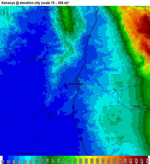
Below is the Elevation map of Kananya, which displays elevation range with different colors. Scale of the first map is from 15 to 454 m (49 to 1490 ft) with average elevation of 82.5 meters (=271 ft) [note 1]
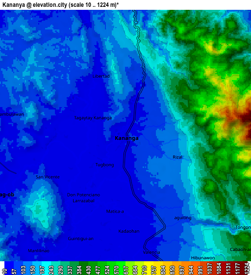
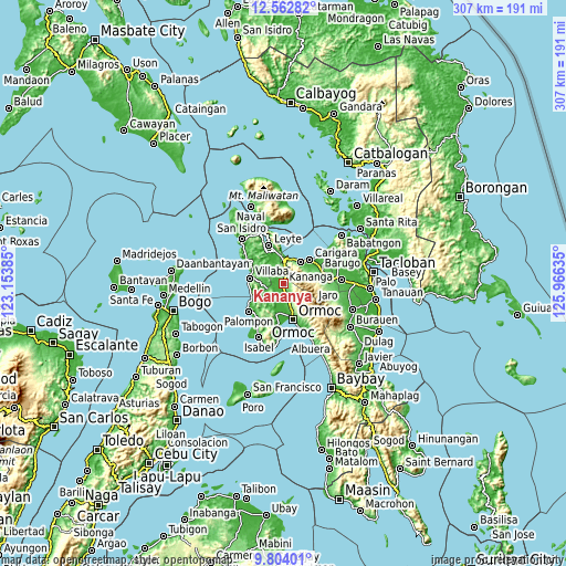
These maps also provides idea of topography and contour of this city, they are displayed at different zoom levels. More info about maps, scale and edge coordinates you can find below images.
| \ | Map #1 | Map #2 | Topo.Map |
| Scale [m] | 15..454 m | 10..1224 m | × |
| Scale [ft] | 49..1490 ft | 33..4016 ft | × |
| Average | 82.5 m = 271 ft | 179.5 m = 589 ft | × |
| Width | 9.59 km = 6 mi | 19.17 km = 11.9 mi | 306.8 km = 190.6 mi |
| Height | 9.59 km = 6 mi | 19.17 km = 11.9 mi | 306.8 km = 190.6 mi |
| ↑Max Latitude | 11.229807° | 11.272908° | 12.56282° |
| Latitude at center | 11.1867° | 11.1867° | 11.1867° |
| ↓Min Latitude | 11.143586° | 11.100466° | 9.80401° |
| ← Min Longitude | 124.516155° | 124.472209° | 123.15385° |
| Longitude center | 124.5601° | 124.5601° | 124.5601° |
| →Max Longitude | 124.604045° | 124.647991° | 125.96635° |
Nearby cities:
Cities around Kananya sort by population:
• Rizal elevation 90 m
2.4 km,  118°
118°
• Valencia 38 m
8.8 km,  171°
171°
• Consuegra 9 m
13.4 km,  337°
337°
• Naghalin 39 m
4.6 km, 170°
• Pinamopoan 27 m
14.3 km,  6°
6°
• Malilinao 19 m
11 km,  215°
215°
• Balagtas 24 m
7.4 km, 216°
• Lim-oo 327 m
8.7 km, 117°
• Limon 56 m
11.4 km,  3°
3°
• Masarayao 235 m
12.5 km,  149°
149°
• San Vicente 40 m
7.6 km,  175°
175°
• Santo Niño 10 m
13.7 km, 179°
Multilingual:
 En español:
Kananya elevación 40 m.
 En France:
Kananya élévation 40 m.


Sources and notes:
- [note 1] Map square and city borders are not equal. Map elevation data is calculated only from area inside that square.
- [src 1] Elevation data from geonames database provided with same terms of usage.
- [src 2] The elevation map of Kananya is generated using elevation data from NASA's 3 arcsec (90m) resolution SRTM data.
- [src 3] Base (background) map © OpenStreetMap contributors tiles are generated by Geofabrik and OpenTopoMap.
Copyright & License:
This Kananya Elevation Map is licensed under CC BY-SA. You may reuse any part from this page, if you give a proper credit by linking to this URL:
 More info on terms of use page.