Kansipati elevation
Kansipati (Autonomous Region in Muslim Mindanao, Province of Sulu), Philippines elevation is 21 meters and Kansipati elevation in feet is 69 ft above sea level [src 1]. Kansipati is a populated place (feature code) with elevation that is 67 meters (220 ft) smaller than average city elevation in Philippines.
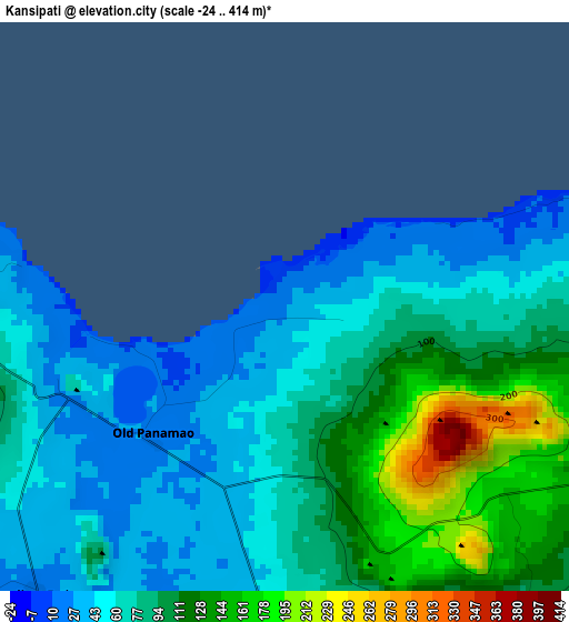
Below is the Elevation map of Kansipati, which displays elevation range with different colors. Scale of the first map is from -24 to 414 m (-79 to 1358 ft) with average elevation of 82.5 meters (=271 ft) [note 1]
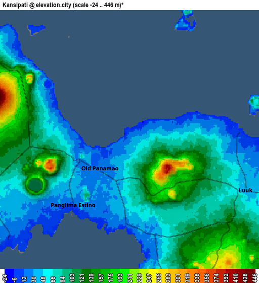
These maps also provides idea of topography and contour of this city, they are displayed at different zoom levels. More info about maps, scale and edge coordinates you can find below images.
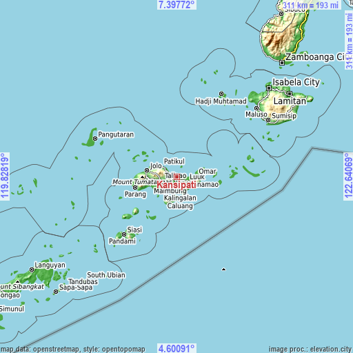
| \ | Map #1 | Map #2 | Topo.Map |
| Scale [m] | -24..414 m | -24..446 m | × |
| Scale [ft] | -79..1358 ft | -79..1463 ft | × |
| Average | 82.5 m = 271 ft | 87.1 m = 286 ft | × |
| Width | 9.72 km = 6 mi | 19.44 km = 12.1 mi | 311 km = 193.2 mi |
| Height | 9.72 km = 6 mi | 19.44 km = 12.1 mi | 311 km = 193.2 mi |
| ↑Max Latitude | 6.044813° | 6.088512° | 7.39772° |
| Latitude at center | 6.00111° | 6.00111° | 6.00111° |
| ↓Min Latitude | 5.957404° | 5.913694° | 4.60091° |
| ← Min Longitude | 121.190495° | 121.146549° | 119.82819° |
| Longitude center | 121.23444° | 121.23444° | 121.23444° |
| →Max Longitude | 121.278385° | 121.322331° | 122.64069° |
Nearby cities:
Cities around Kansipati sort by population:
• Lu-uk elevation 39 m
9.3 km,  112°
112°
• Karungdong 8 m
13.4 km,  166°
166°
• Punay 28 m
6 km,  222°
222°
• Pitogo 2 m
15.2 km,  145°
145°
• Pandakan 122 m
7.7 km,  259°
259°
• Kulay-Kulay 23 m
6.2 km,  181°
181°
• Pang 85 m
8.4 km,  134°
134°
• Mahala 22 m
14.6 km,  229°
229°
• Kambing 104 m
10.1 km, 126°
• Talipao 81 m
13.4 km, 258°
• New Panamao 6 m
6.8 km,  213°
213°
• Pananaw 20 m
3.1 km, 224°
Multilingual:
 En español:
Kansipati elevación 21 m.
 En France:
Kansipati élévation 21 m.
 Auf Deutsch:
Kansipati höhe über dem Meeresspiegel ist 21 m.

Sources and notes:
- [note 1] Map square and city borders are not equal. Map elevation data is calculated only from area inside that square.
- [src 1] Elevation data from geonames database provided with same terms of usage.
- [src 2] The elevation map of Kansipati is generated using elevation data from NASA's 3 arcsec (90m) resolution SRTM data.
- [src 3] Base (background) map © OpenStreetMap contributors tiles are generated by Geofabrik and OpenTopoMap.
Copyright & License:
This Kansipati Elevation Map is licensed under CC BY-SA. You may reuse any part from this page, if you give a proper credit by linking to this URL:
 More info on terms of use page.