Kumalarang elevation
Kumalarang (Zamboanga Peninsula, Province of Zamboanga del Sur), Philippines elevation is 6 meters and Kumalarang elevation in feet is 20 ft above sea level [src 1]. Kumalarang is a populated place (feature code) with elevation that is 82 meters (269 ft) smaller than average city elevation in Philippines.
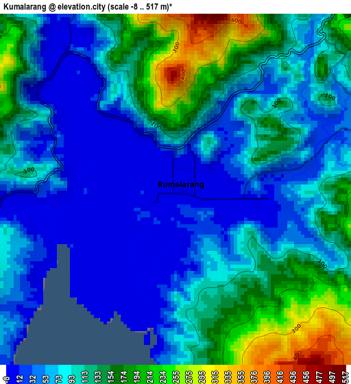
Below is the Elevation map of Kumalarang, which displays elevation range with different colors. Scale of the first map is from -8 to 517 m (-26 to 1696 ft) with average elevation of 97.4 meters (=320 ft) [note 1]
These maps also provides idea of topography and contour of this city, they are displayed at different zoom levels. More info about maps, scale and edge coordinates you can find below images.
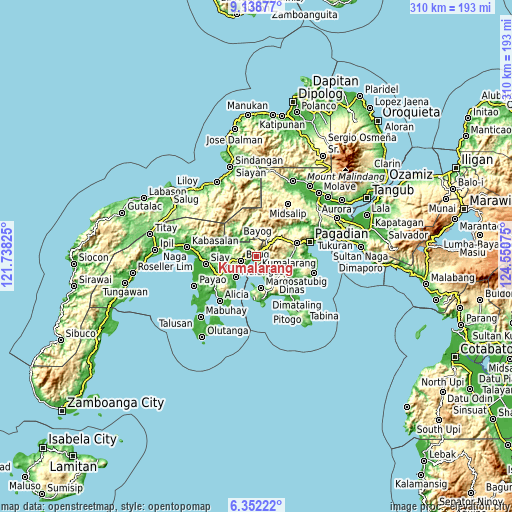
| \ | Map #1 | Map #2 | Topo.Map |
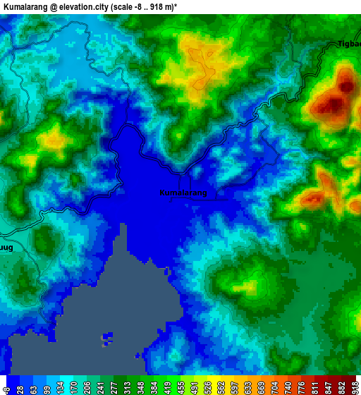
| Scale [m] | -8..517 m | -8..918 m | × |
| Scale [ft] | -26..1696 ft | -26..3012 ft | × |
| Average | 97.4 m = 320 ft | 225.8 m = 741 ft | × |
| Width | 9.68 km = 6 mi | 19.37 km = 12 mi | 309.8 km = 192.5 mi |
| Height | 9.68 km = 6 mi | 19.37 km = 12 mi | 309.9 km = 192.6 mi |
| ↑Max Latitude | 7.791342° | 7.834879° | 9.13877° |
| Latitude at center | 7.7478° | 7.7478° | 7.7478° |
| ↓Min Latitude | 7.704254° | 7.660703° | 6.35222° |
| ← Min Longitude | 123.100555° | 123.056609° | 121.73825° |
| Longitude center | 123.1445° | 123.1445° | 123.1445° |
| →Max Longitude | 123.188445° | 123.232391° | 124.55075° |
Nearby cities:
Cities around Kumalarang sort by population:
• Margosatubig elevation 8 m
19.1 km,  172°
172°
• Buug 194 m
9.6 km,  257°
257°
• Malangas 26 m
18 km,  223°
223°
• Rancheria Payau 336 m
11.9 km,  8°
8°
• Lapuyan 24 m
13.4 km,  155°
155°
• Bayog 56 m
15.8 km,  327°
327°
• Diplahan 219 m
14.5 km, 256°
• La Dicha 107 m
17.6 km,  242°
242°
• Dipolo 6 m
5 km,  320°
320°
• San Miguel 253 m
17.5 km,  129°
129°
• Del Monte 219 m
15.2 km, 260°
• Tiguha 266 m
8.8 km,  123°
123°
Multilingual:
 En español:
Kumalarang elevación 6 m.
 En France:
Kumalarang élévation 6 m.
 Auf Deutsch:
Kumalarang höhe über dem Meeresspiegel ist 6 m.

Sources and notes:
- [note 1] Map square and city borders are not equal. Map elevation data is calculated only from area inside that square.
- [src 1] Elevation data from geonames database provided with same terms of usage.
- [src 2] The elevation map of Kumalarang is generated using elevation data from NASA's 3 arcsec (90m) resolution SRTM data.
- [src 3] Base (background) map © OpenStreetMap contributors tiles are generated by Geofabrik and OpenTopoMap.
Copyright & License:
This Kumalarang Elevation Map is licensed under CC BY-SA. You may reuse any part from this page, if you give a proper credit by linking to this URL:
 More info on terms of use page.