Kumalisquis elevation
Kumalisquis (Western Visayas, Province of Negros Occidental), Philippines elevation is 577 meters and Kumalisquis elevation in feet is 1893 ft above sea level [src 1]. Kumalisquis is a populated place (feature code) with elevation that is 489 meters (1604 ft) bigger than average city elevation in Philippines.
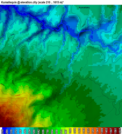
Below is the Elevation map of Kumalisquis, which displays elevation range with different colors. Scale of the first map is from 210 to 1615 m (689 to 5299 ft) with average elevation of 616 meters (=2021 ft) [note 1]
These maps also provides idea of topography and contour of this city, they are displayed at different zoom levels. More info about maps, scale and edge coordinates you can find below images.
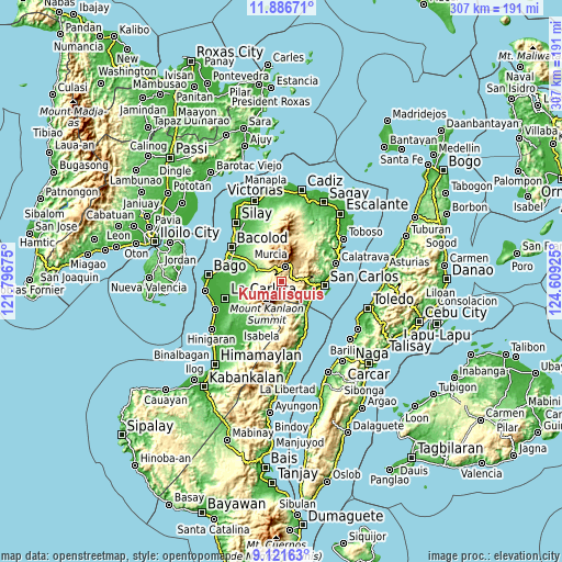
| \ | Map #1 | Topo.Map |
| Scale [m] | 210..1615 m | × |
| Scale [ft] | 689..5299 ft | × |
| Average | 616 m = 2021 ft | × |
| Width | 9.61 km = 6 mi | 307.4 km = 191 mi |
| Height | 9.61 km = 6 mi | 307.5 km = 191.1 mi |
| ↑Max Latitude | 10.550465° | 11.88671° |
| Latitude at center | 10.50726° | 10.50726° |
| ↓Min Latitude | 10.464049° | 9.12163° |
| ← Min Longitude | 123.159055° | 121.79675° |
| Longitude center | 123.203° | 123.203° |
| →Max Longitude | 123.246945° | 124.60925° |
Nearby cities:
Cities around Kumalisquis sort by population:
• Canlaon elevation 479 m
13.5 km,  170°
170°
• Codcod 587 m
7 km,  133°
133°
• Quezon 529 m
10.1 km,  141°
141°
• Guadalupe 6 m
19.5 km,  107°
107°
• Minuyan 346 m
10.7 km,  273°
273°
• Prosperidad 697 m
11.6 km,  85°
85°
• Hacienda Santa Rosa 169 m
13.3 km,  303°
303°
• Igmaya-an 570 m
5.1 km,  22°
22°
• Santa Cruz 252 m
19.3 km,  316°
316°
• Buenavista 265 m
16.5 km, 316°
• New Pandanon 190 m
8.2 km,  312°
312°
• San Miguel 158 m
13.6 km,  284°
284°
Multilingual:
 En español:
Kumalisquis elevación 577 m.
 En France:
Kumalisquis élévation 577 m.
 Auf Deutsch:
Kumalisquis höhe über dem Meeresspiegel ist 577 m.

Sources and notes:
- [note 1] Map square and city borders are not equal. Map elevation data is calculated only from area inside that square.
- [src 1] Elevation data from geonames database provided with same terms of usage.
- [src 2] The elevation map of Kumalisquis is generated using elevation data from NASA's 3 arcsec (90m) resolution SRTM data.
- [src 3] Base (background) map © OpenStreetMap contributors tiles are generated by Geofabrik and OpenTopoMap.
Copyright & License:
This Kumalisquis Elevation Map is licensed under CC BY-SA. You may reuse any part from this page, if you give a proper credit by linking to this URL:
 More info on terms of use page.