Langcangan elevation
Langcangan (Northern Mindanao, Province of Misamis Occidental), Philippines elevation is 130 meters and Langcangan elevation in feet is 427 ft above sea level [src 1]. Langcangan is a populated place (feature code) with elevation that is 42 meters (138 ft) bigger than average city elevation in Philippines.
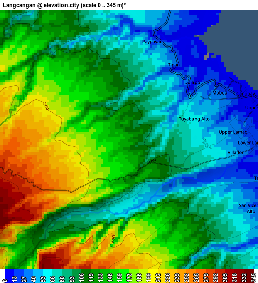
Below is the Elevation map of Langcangan, which displays elevation range with different colors. Scale of the first map is from 0 to 345 m (0 to 1132 ft) with average elevation of 124.6 meters (=409 ft) [note 1]
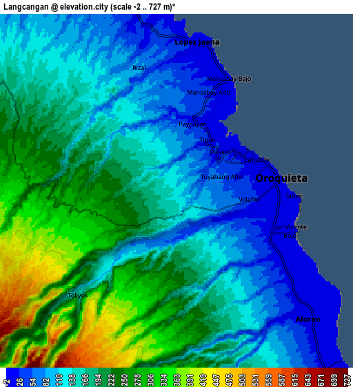
These maps also provides idea of topography and contour of this city, they are displayed at different zoom levels. More info about maps, scale and edge coordinates you can find below images.
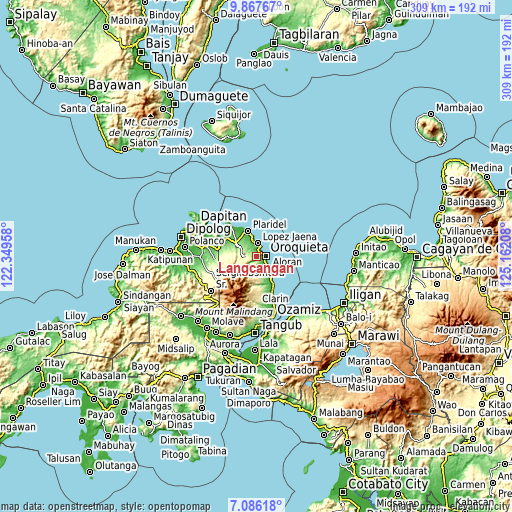
| \ | Map #1 | Map #2 | Topo.Map |
| Scale [m] | 0..345 m | -2..727 m | × |
| Scale [ft] | 0..1132 ft | -7..2385 ft | × |
| Average | 124.6 m = 409 ft | 179.2 m = 588 ft | × |
| Width | 9.67 km = 6 mi | 19.33 km = 12 mi | 309.3 km = 192.2 mi |
| Height | 9.67 km = 6 mi | 19.33 km = 12 mi | 309.3 km = 192.2 mi |
| ↑Max Latitude | 8.522902° | 8.56636° | 9.86767° |
| Latitude at center | 8.47944° | 8.47944° | 8.47944° |
| ↓Min Latitude | 8.435973° | 8.3925° | 7.08618° |
| ← Min Longitude | 123.711885° | 123.667939° | 122.34958° |
| Longitude center | 123.75583° | 123.75583° | 123.75583° |
| →Max Longitude | 123.799775° | 123.843721° | 125.16208° |
Nearby cities:
Cities around Langcangan sort by population:
• Oroquieta elevation 6 m
5.4 km,  82°
82°
• Calamba 115 m
15.3 km,  305°
305°
• Jimenez 26 m
18.3 km,  150°
150°
• Lopez Jaena 19 m
8.2 km,  4°
4°
• Pines 4 m
6.4 km,  118°
118°
• Plaridel 5 m
16.6 km,  342°
342°
• Tubao 1 m
19.5 km, 146°
• Bato 39 m
18.3 km,  318°
318°
• Sapang Dalaga 109 m
22.3 km,  287°
287°
• Sinonoc 5 m
21.3 km, 152°
• Sinacaban 26 m
23.4 km,  156°
156°
• Unidos 37 m
16 km, 322°
Multilingual:
 En español:
Langcangan elevación 130 m.
 En France:
Langcangan élévation 130 m.
 Auf Deutsch:
Langcangan höhe über dem Meeresspiegel ist 130 m.

Sources and notes:
- [note 1] Map square and city borders are not equal. Map elevation data is calculated only from area inside that square.
- [src 1] Elevation data from geonames database provided with same terms of usage.
- [src 2] The elevation map of Langcangan is generated using elevation data from NASA's 3 arcsec (90m) resolution SRTM data.
- [src 3] Base (background) map © OpenStreetMap contributors tiles are generated by Geofabrik and OpenTopoMap.
Copyright & License:
This Langcangan Elevation Map is licensed under CC BY-SA. You may reuse any part from this page, if you give a proper credit by linking to this URL:
 More info on terms of use page.