Libato elevation
Libato (Calabarzon, Province of Batangas), Philippines elevation is 56 meters and Libato elevation in feet is 184 ft above sea level [src 1]. Libato is a populated place (feature code) with elevation that is 32 meters (105 ft) smaller than average city elevation in Philippines.
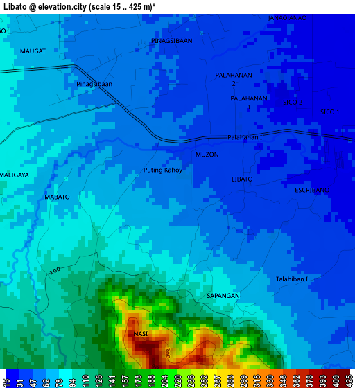
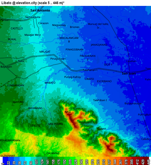
Below is the Elevation map of Libato, which displays elevation range with different colors. Scale of the first map is from 15 to 425 m (49 to 1394 ft) with average elevation of 75.9 meters (=249 ft) [note 1]
These maps also provides idea of topography and contour of this city, they are displayed at different zoom levels. More info about maps, scale and edge coordinates you can find below images.
| \ | Map #1 | Map #2 | Topo.Map |
| Scale [m] | 15..425 m | 5..446 m | × |
| Scale [ft] | 49..1394 ft | 16..1463 ft | × |
| Average | 75.9 m = 249 ft | 97.2 m = 319 ft | × |
| Width | 9.49 km = 5.9 mi | 18.98 km = 11.8 mi | 303.6 km = 188.6 mi |
| Height | 9.49 km = 5.9 mi | 18.98 km = 11.8 mi | 303.7 km = 188.7 mi |
| ↑Max Latitude | 13.85781° | 13.900472° | 15.17659° |
| Latitude at center | 13.81514° | 13.81514° | 13.81514° |
| ↓Min Latitude | 13.772462° | 13.729776° | 12.44569° |
| ← Min Longitude | 121.290685° | 121.246739° | 119.92838° |
| Longitude center | 121.33463° | 121.33463° | 121.33463° |
| →Max Longitude | 121.378575° | 121.422521° | 122.74088° |
Nearby cities:
Cities around Libato sort by population:
• Santa Catalina Norte elevation 30 m
6.7 km,  21°
21°
• Alupay 59 m
4.6 km,  320°
320°
• Sico Uno 27 m
4.3 km,  67°
67°
• Palahanan Uno 31 m
2.9 km,  52°
52°
• Lipahan 18 m
7.6 km, 71°
• Talahiban I 25 m
5.1 km,  100°
100°
• Macalamcam A 45 m
4.7 km,  351°
351°
• Pinagsibaan 61 m
2.6 km,  326°
326°
• Putingkahoy 49 m
1.8 km,  335°
335°
• Sampiro 50 m
6.4 km,  122°
122°
• Baybayin 126 m
7 km,  275°
275°
• San Juan 21 m
7.2 km, 73°
Multilingual:
 En español:
Libato elevación 56 m.
 En France:
Libato élévation 56 m.


Sources and notes:
- [note 1] Map square and city borders are not equal. Map elevation data is calculated only from area inside that square.
- [src 1] Elevation data from geonames database provided with same terms of usage.
- [src 2] The elevation map of Libato is generated using elevation data from NASA's 3 arcsec (90m) resolution SRTM data.
- [src 3] Base (background) map © OpenStreetMap contributors tiles are generated by Geofabrik and OpenTopoMap.
Copyright & License:
This Libato Elevation Map is licensed under CC BY-SA. You may reuse any part from this page, if you give a proper credit by linking to this URL:
 More info on terms of use page.