Libertad elevation
Libertad (Caraga, Province of Agusan del Sur), Philippines elevation is 33 meters and Libertad elevation in feet is 108 ft above sea level [src 1]. Libertad is a populated place (feature code) with elevation that is 55 meters (180 ft) smaller than average city elevation in Philippines.
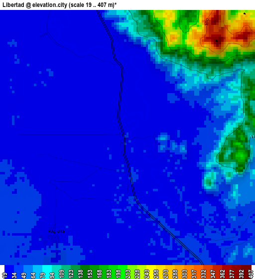
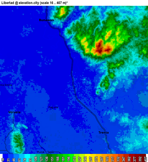
Below is the Elevation map of Libertad, which displays elevation range with different colors. Scale of the first map is from 19 to 407 m (62 to 1335 ft) with average elevation of 55.4 meters (=182 ft) [note 1]
These maps also provides idea of topography and contour of this city, they are displayed at different zoom levels. More info about maps, scale and edge coordinates you can find below images.
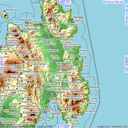
| \ | Map #1 | Map #2 | Topo.Map |
| Scale [m] | 19..407 m | 16..407 m | × |
| Scale [ft] | 62..1335 ft | 52..1335 ft | × |
| Average | 55.4 m = 182 ft | 59.9 m = 197 ft | × |
| Width | 9.67 km = 6 mi | 19.35 km = 12 mi | 309.6 km = 192.4 mi |
| Height | 9.67 km = 6 mi | 19.35 km = 12 mi | 309.6 km = 192.4 mi |
| ↑Max Latitude | 8.151004° | 8.194503° | 9.49715° |
| Latitude at center | 8.1075° | 8.1075° | 8.1075° |
| ↓Min Latitude | 8.063992° | 8.020478° | 6.71303° |
| ← Min Longitude | 125.982445° | 125.938499° | 124.62014° |
| Longitude center | 126.02639° | 126.02639° | 126.02639° |
| →Max Longitude | 126.070335° | 126.114281° | 127.43264° |
Nearby cities:
Cities around Libertad sort by population:
• Veruela elevation 31 m
8.7 km,  243°
243°
• Trento 38 m
8 km,  149°
149°
• Bunawan 25 m
7.7 km,  329°
329°
• Salvacion 69 m
16.2 km,  137°
137°
• Loreto 25 m
21 km,  294°
294°
• Pasian 50 m
20.5 km,  167°
167°
• Santa Josefa 36 m
12.9 km,  178°
178°
• Sinubong 29 m
11.4 km,  247°
247°
• Santo Tomas 31 m
26 km, 289°
• Santa Maria 63 m
17.1 km,  118°
118°
• Basa 33 m
5.7 km,  133°
133°
• Cuevas 50 m
12.3 km, 142°
Multilingual:
 En español:
Libertad elevación 33 m.
 En France:
Libertad élévation 33 m.


Sources and notes:
- [note 1] Map square and city borders are not equal. Map elevation data is calculated only from area inside that square.
- [src 1] Elevation data from geonames database provided with same terms of usage.
- [src 2] The elevation map of Libertad is generated using elevation data from NASA's 3 arcsec (90m) resolution SRTM data.
- [src 3] Base (background) map © OpenStreetMap contributors tiles are generated by Geofabrik and OpenTopoMap.
Copyright & License:
This Libertad Elevation Map is licensed under CC BY-SA. You may reuse any part from this page, if you give a proper credit by linking to this URL:
 More info on terms of use page.