Limanancong elevation
Limanancong (Mimaropa, Province of Palawan), Philippines elevation is 8 meters and Limanancong elevation in feet is 26 ft above sea level [src 1]. Limanancong is a populated place (feature code) with elevation that is 80 meters (262 ft) smaller than average city elevation in Philippines.
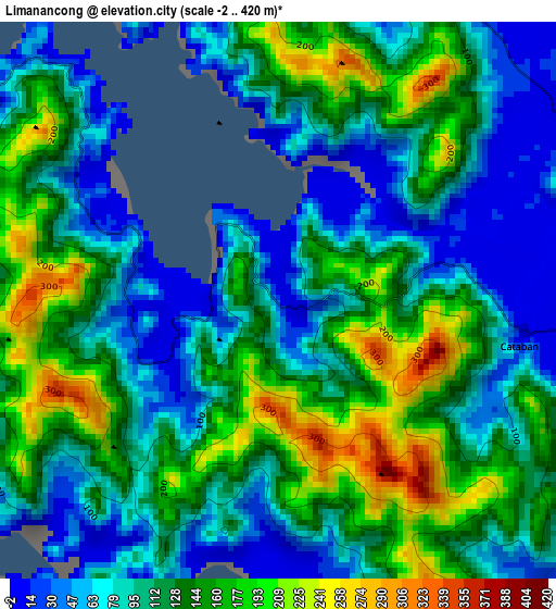
Below is the Elevation map of Limanancong, which displays elevation range with different colors. Scale of the first map is from -2 to 420 m (-7 to 1378 ft) with average elevation of 118.5 meters (=389 ft) [note 1]
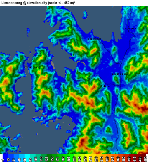
These maps also provides idea of topography and contour of this city, they are displayed at different zoom levels. More info about maps, scale and edge coordinates you can find below images.
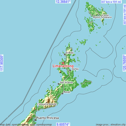
| \ | Map #1 | Map #2 | Topo.Map |
| Scale [m] | -2..420 m | -4..450 m | × |
| Scale [ft] | -7..1378 ft | -13..1476 ft | × |
| Average | 118.5 m = 389 ft | 112.5 m = 369 ft | × |
| Width | 9.59 km = 6 mi | 19.19 km = 11.9 mi | 307 km = 190.8 mi |
| Height | 9.59 km = 6 mi | 19.19 km = 11.9 mi | 307 km = 190.8 mi |
| ↑Max Latitude | 11.032436° | 11.075566° | 12.36641° |
| Latitude at center | 10.9893° | 10.9893° | 10.9893° |
| ↓Min Latitude | 10.946157° | 10.903008° | 9.60574° |
| ← Min Longitude | 119.315355° | 119.271409° | 117.95305° |
| Longitude center | 119.3593° | 119.3593° | 119.3593° |
| →Max Longitude | 119.403245° | 119.447191° | 120.76555° |
Nearby cities:
Cities around Limanancong sort by population:
• El Nido elevation 36 m
22.2 km,  10°
10°
• Taytay 22 m
24.4 km,  141°
141°
• Port Barton 7 m
58.4 km,  192°
192°
• San Vicente 1 m
52.3 km, 192°
• Calauag 14 m
42.5 km,  147°
147°
• Guinlo 3 m
22.7 km,  157°
157°
• Alemanguan 1 m
42.1 km,  184°
184°
• Tiniguiban 7 m
43.9 km,  21°
21°
• Casian 7 m
39 km,  82°
82°
• Bato 8 m
22 km, 146°
• New Agutaya 4 m
47.9 km, 186°
• Pancol 13 m
14.5 km, 154°
Multilingual:
 En español:
Limanancong elevación 8 m.
 En France:
Limanancong élévation 8 m.
 Auf Deutsch:
Limanancong höhe über dem Meeresspiegel ist 8 m.

Sources and notes:
- [note 1] Map square and city borders are not equal. Map elevation data is calculated only from area inside that square.
- [src 1] Elevation data from geonames database provided with same terms of usage.
- [src 2] The elevation map of Limanancong is generated using elevation data from NASA's 3 arcsec (90m) resolution SRTM data.
- [src 3] Base (background) map © OpenStreetMap contributors tiles are generated by Geofabrik and OpenTopoMap.
Copyright & License:
This Limanancong Elevation Map is licensed under CC BY-SA. You may reuse any part from this page, if you give a proper credit by linking to this URL:
 More info on terms of use page.