Magapit, Aguiguican elevation
Magapit, Aguiguican (Cagayan Valley, Province of Cagayan), Philippines elevation is 12 meters and Magapit, Aguiguican elevation in feet is 39 ft above sea level [src 1]. Magapit, Aguiguican is a section of populated place (feature code) with elevation that is 76 meters (249 ft) smaller than average city elevation in Philippines.
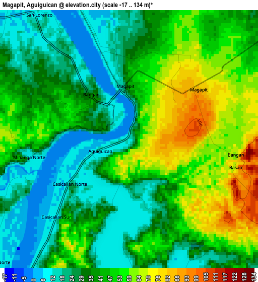
Below is the Elevation map of Magapit, Aguiguican, which displays elevation range with different colors. Scale of the first map is from -17 to 134 m (-56 to 440 ft) with average elevation of 40.4 meters (=133 ft) [note 1]
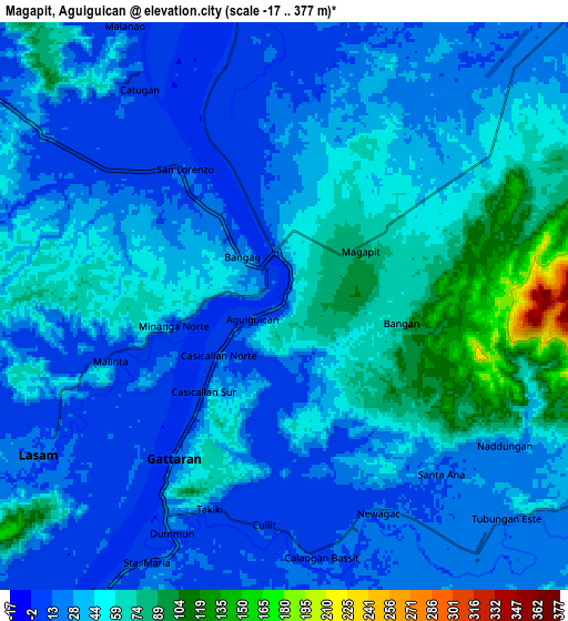
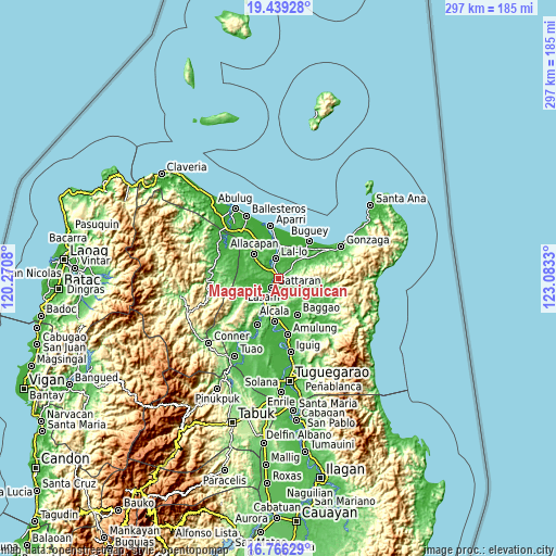
These maps also provides idea of topography and contour of this city, they are displayed at different zoom levels. More info about maps, scale and edge coordinates you can find below images.
| \ | Map #1 | Map #2 | Topo.Map |
| Scale [m] | -17..134 m | -17..377 m | × |
| Scale [ft] | -56..440 ft | -56..1237 ft | × |
| Average | 40.4 m = 133 ft | 39.8 m = 131 ft | × |
| Width | 9.29 km = 5.8 mi | 18.58 km = 11.5 mi | 297.2 km = 184.7 mi |
| Height | 9.29 km = 5.8 mi | 18.58 km = 11.5 mi | 297.2 km = 184.7 mi |
| ↑Max Latitude | 18.149644° | 18.191398° | 19.43928° |
| Latitude at center | 18.10788° | 18.10788° | 18.10788° |
| ↓Min Latitude | 18.066106° | 18.024322° | 16.76629° |
| ← Min Longitude | 121.633105° | 121.589159° | 120.2708° |
| Longitude center | 121.67705° | 121.67705° | 121.67705° |
| →Max Longitude | 121.720995° | 121.764941° | 123.0833° |
Nearby cities:
Cities around Magapit, Aguiguican sort by population:
• Magapit elevation 9 m
3.4 km,  346°
346°
• Lasam 15 m
9.4 km,  239°
239°
• Catayauan 10 m
6.4 km,  336°
336°
• Gattaran 17 m
6.2 km,  214°
214°
• Nabannagan West 22 m
15.4 km,  254°
254°
• Palagao Norte 18 m
8.4 km,  148°
148°
• Capissayan Sur 37 m
16.2 km,  113°
113°
• Santa Maria 13 m
3.9 km, 340°
• Calaoagan 19 m
8.7 km, 145°
• Maxingal 6 m
11.9 km,  355°
355°
• Bagumbayan 9 m
9.7 km, 351°
• Alannay 16 m
10.9 km, 241°
Multilingual:
 En español:
Magapit, Aguiguican elevación 12 m.
 En France:
Magapit, Aguiguican élévation 12 m.
 Auf Deutsch:
Magapit, Aguiguican höhe über dem Meeresspiegel ist 12 m.
 На русском:
Magapit, Aguiguican высота над уровнем моря 12 м
Sources and notes:
- [note 1] Map square and city borders are not equal. Map elevation data is calculated only from area inside that square.
- [src 1] Elevation data from geonames database provided with same terms of usage.
- [src 2] The elevation map of Magapit, Aguiguican is generated using elevation data from NASA's 3 arcsec (90m) resolution SRTM data.
- [src 3] Base (background) map © OpenStreetMap contributors tiles are generated by Geofabrik and OpenTopoMap.
Copyright & License:
This Magapit, Aguiguican Elevation Map is licensed under CC BY-SA. You may reuse any part from this page, if you give a proper credit by linking to this URL:
 More info on terms of use page.