Mahayag elevation
Mahayag (Zamboanga Peninsula, Province of Zamboanga del Sur), Philippines elevation is 28 meters and Mahayag elevation in feet is 92 ft above sea level [src 1]. Mahayag is a populated place (feature code) with elevation that is 60 meters (197 ft) smaller than average city elevation in Philippines.
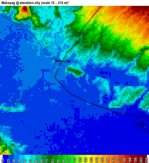
Below is the Elevation map of Mahayag, which displays elevation range with different colors. Scale of the first map is from 15 to 210 m (49 to 689 ft) with average elevation of 48.4 meters (=159 ft) [note 1]
These maps also provides idea of topography and contour of this city, they are displayed at different zoom levels. More info about maps, scale and edge coordinates you can find below images.
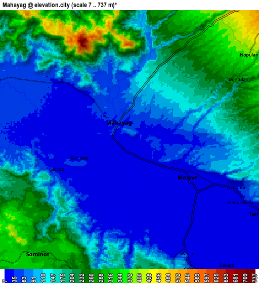
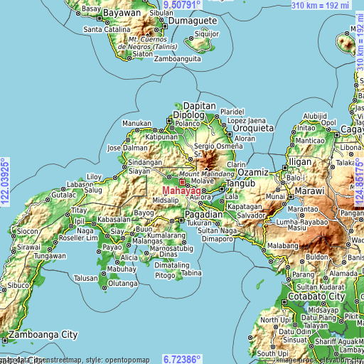
| \ | Map #1 | Map #2 | Topo.Map |
| Scale [m] | 15..210 m | 7..737 m | × |
| Scale [ft] | 49..689 ft | 23..2418 ft | × |
| Average | 48.4 m = 159 ft | 135.1 m = 443 ft | × |
| Width | 9.67 km = 6 mi | 19.35 km = 12 mi | 309.6 km = 192.4 mi |
| Height | 9.67 km = 6 mi | 19.35 km = 12 mi | 309.6 km = 192.4 mi |
| ↑Max Latitude | 8.161803° | 8.2053° | 9.50791° |
| Latitude at center | 8.1183° | 8.1183° | 8.1183° |
| ↓Min Latitude | 8.074793° | 8.031281° | 6.72386° |
| ← Min Longitude | 123.401555° | 123.357609° | 122.03925° |
| Longitude center | 123.4455° | 123.4455° | 123.4455° |
| →Max Longitude | 123.489445° | 123.533391° | 124.85175° |
Nearby cities:
Cities around Mahayag sort by population:
• Molave elevation 18 m
6.3 km,  126°
126°
• Aurora 259 m
24 km,  141°
141°
• Tambulig 25 m
11.2 km,  118°
118°
• Dumingag 63 m
11.9 km,  298°
298°
• Sergio Osmeña Sr 275 m
8.1 km,  48°
48°
• Ramon Magsaysay 216 m
14.7 km,  151°
151°
• Gubaan 221 m
20.6 km, 140°
• Midsalip 848 m
23.7 km,  236°
236°
• Josefina 539 m
13.3 km, 46°
• Tiparak 10 m
13.1 km, 135°
• Balagon 545 m
25.9 km, 241°
• Bonifacio 101 m
20 km,  111°
111°
Multilingual:
 En español:
Mahayag elevación 28 m.
 En France:
Mahayag élévation 28 m.


Sources and notes:
- [note 1] Map square and city borders are not equal. Map elevation data is calculated only from area inside that square.
- [src 1] Elevation data from geonames database provided with same terms of usage.
- [src 2] The elevation map of Mahayag is generated using elevation data from NASA's 3 arcsec (90m) resolution SRTM data.
- [src 3] Base (background) map © OpenStreetMap contributors tiles are generated by Geofabrik and OpenTopoMap.
Copyright & License:
This Mahayag Elevation Map is licensed under CC BY-SA. You may reuse any part from this page, if you give a proper credit by linking to this URL:
 More info on terms of use page.