Malabanan elevation
Malabanan (Calabarzon, Province of Batangas), Philippines elevation is 271 meters and Malabanan elevation in feet is 889 ft above sea level [src 1]. Malabanan is a populated place (feature code) with elevation that is 183 meters (600 ft) bigger than average city elevation in Philippines.
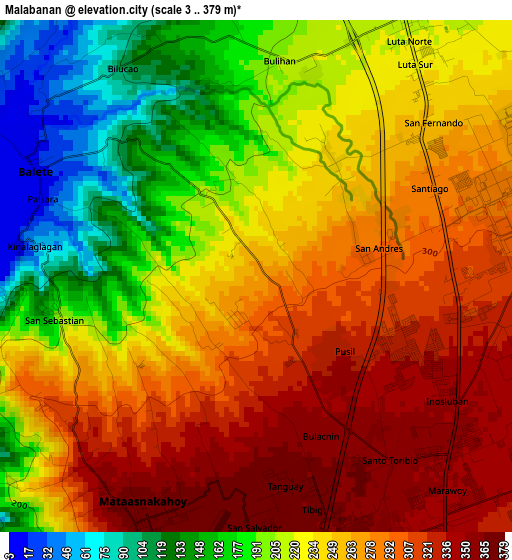
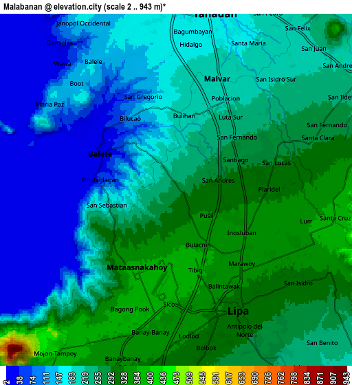
Below is the Elevation map of Malabanan, which displays elevation range with different colors. Scale of the first map is from 3 to 379 m (10 to 1243 ft) with average elevation of 243.2 meters (=798 ft) [note 1]
These maps also provides idea of topography and contour of this city, they are displayed at different zoom levels. More info about maps, scale and edge coordinates you can find below images.
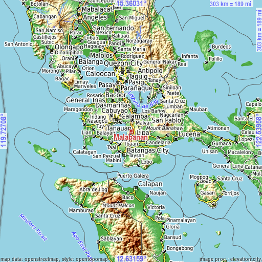
| \ | Map #1 | Map #2 | Topo.Map |
| Scale [m] | 3..379 m | 2..943 m | × |
| Scale [ft] | 10..1243 ft | 7..3094 ft | × |
| Average | 243.2 m = 798 ft | 217.4 m = 713 ft | × |
| Width | 9.48 km = 5.9 mi | 18.96 km = 11.8 mi | 303.4 km = 188.5 mi |
| Height | 9.48 km = 5.9 mi | 18.96 km = 11.8 mi | 303.4 km = 188.5 mi |
| ↑Max Latitude | 14.042636° | 14.085264° | 15.36031° |
| Latitude at center | 14° | 14° | 14° |
| ↓Min Latitude | 13.957356° | 13.914704° | 12.63159° |
| ← Min Longitude | 121.089385° | 121.045439° | 119.72708° |
| Longitude center | 121.13333° | 121.13333° | 121.13333° |
| →Max Longitude | 121.177275° | 121.221221° | 122.53958° |
Nearby cities:
Cities around Malabanan sort by population:
• Lipa City elevation 325 m
7.3 km,  153°
153°
• Malvar 210 m
5.7 km,  28°
28°
• Balete 16 m
4.7 km,  298°
298°
• Banaybanay 367 m
7.7 km,  194°
194°
• Bulacnin 313 m
1.2 km, 150°
• Boot 139 m
7.9 km,  309°
309°
• San Pedro One 199 m
6.1 km,  12°
12°
• San Isidro 96 m
4.5 km,  325°
325°
• San Andres 293 m
2 km,  78°
78°
• Mahabang Parang 5 m
5.7 km,  251°
251°
• Kinalaglagan 86 m
3.8 km,  272°
272°
• Mataas Na Kahoy 374 m
5 km,  204°
204°
Multilingual:
 En español:
Malabanan elevación 271 m.
 En France:
Malabanan élévation 271 m.
 Auf Deutsch:
Malabanan höhe über dem Meeresspiegel ist 271 m.

Sources and notes:
- [note 1] Map square and city borders are not equal. Map elevation data is calculated only from area inside that square.
- [src 1] Elevation data from geonames database provided with same terms of usage.
- [src 2] The elevation map of Malabanan is generated using elevation data from NASA's 3 arcsec (90m) resolution SRTM data.
- [src 3] Base (background) map © OpenStreetMap contributors tiles are generated by Geofabrik and OpenTopoMap.
Copyright & License:
This Malabanan Elevation Map is licensed under CC BY-SA. You may reuse any part from this page, if you give a proper credit by linking to this URL:
 More info on terms of use page.