Malaiba elevation
Malaiba (Central Visayas, Province of Negros Oriental), Philippines elevation is 163 meters and Malaiba elevation in feet is 535 ft above sea level [src 1]. Malaiba is a populated place (feature code) with elevation that is 75 meters (246 ft) bigger than average city elevation in Philippines.
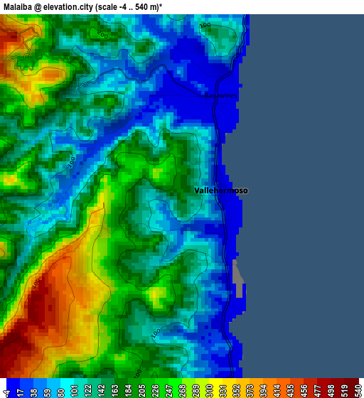
Below is the Elevation map of Malaiba, which displays elevation range with different colors. Scale of the first map is from -4 to 540 m (-13 to 1772 ft) with average elevation of 166.7 meters (=547 ft) [note 1]
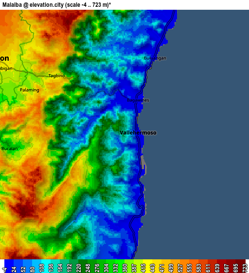
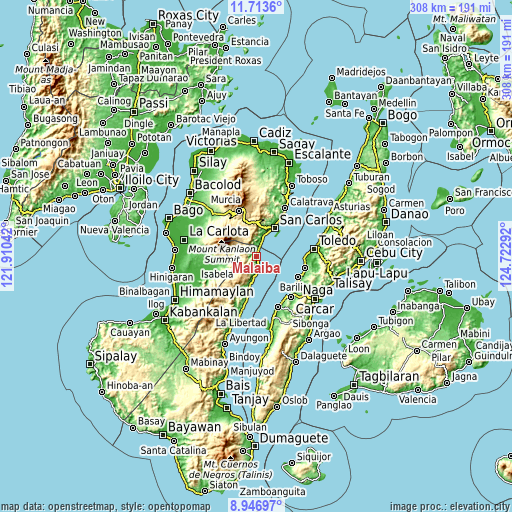
These maps also provides idea of topography and contour of this city, they are displayed at different zoom levels. More info about maps, scale and edge coordinates you can find below images.
| \ | Map #1 | Map #2 | Topo.Map |
| Scale [m] | -4..540 m | -4..723 m | × |
| Scale [ft] | -13..1772 ft | -13..2372 ft | × |
| Average | 166.7 m = 547 ft | 283.6 m = 930 ft | × |
| Width | 9.61 km = 6 mi | 19.23 km = 11.9 mi | 307.6 km = 191.1 mi |
| Height | 9.61 km = 6 mi | 19.23 km = 11.9 mi | 307.6 km = 191.1 mi |
| ↑Max Latitude | 10.37656° | 10.419783° | 11.7136° |
| Latitude at center | 10.33333° | 10.33333° | 10.33333° |
| ↓Min Latitude | 10.290094° | 10.246853° | 8.94697° |
| ← Min Longitude | 123.272725° | 123.228779° | 121.91042° |
| Longitude center | 123.31667° | 123.31667° | 123.31667° |
| →Max Longitude | 123.360615° | 123.404561° | 124.72292° |
Nearby cities:
Cities around Malaiba sort by population:
• Canlaon elevation 479 m
11.9 km,  300°
300°
• Codcod 587 m
16.2 km,  333°
333°
• Buluangan 7 m
6.4 km,  21°
21°
• Quezon 529 m
13 km, 331°
• Guadalupe 6 m
14.8 km, 24°
• Vallehermoso 5 m
1 km,  80°
80°
• Hibaiyo 8 m
6.8 km,  175°
175°
• Pinokawan 56 m
2.6 km,  289°
289°
• Basak 9 m
11.9 km,  185°
185°
• Tabon 12 m
3.6 km,  163°
163°
• Anopog 627 m
11.8 km,  218°
218°
• Guba 311 m
5.9 km,  247°
247°
Multilingual:
 En español:
Malaiba elevación 163 m.
 En France:
Malaiba élévation 163 m.


Sources and notes:
- [note 1] Map square and city borders are not equal. Map elevation data is calculated only from area inside that square.
- [src 1] Elevation data from geonames database provided with same terms of usage.
- [src 2] The elevation map of Malaiba is generated using elevation data from NASA's 3 arcsec (90m) resolution SRTM data.
- [src 3] Base (background) map © OpenStreetMap contributors tiles are generated by Geofabrik and OpenTopoMap.
Copyright & License:
This Malaiba Elevation Map is licensed under CC BY-SA. You may reuse any part from this page, if you give a proper credit by linking to this URL:
 More info on terms of use page.