Maloma elevation
Maloma (Central Luzon, Province of Zambales), Philippines elevation is 14 meters and Maloma elevation in feet is 46 ft above sea level [src 1]. Maloma is a populated place (feature code) with elevation that is 74 meters (243 ft) smaller than average city elevation in Philippines.
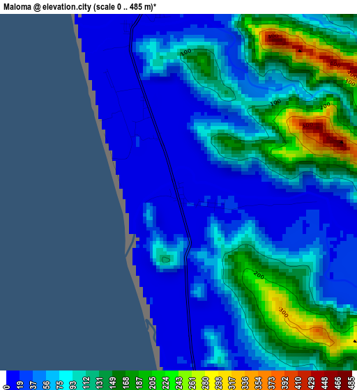
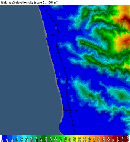
Below is the Elevation map of Maloma, which displays elevation range with different colors. Scale of the first map is from 0 to 485 m (0 to 1591 ft) with average elevation of 88.4 meters (=290 ft) [note 1]
These maps also provides idea of topography and contour of this city, they are displayed at different zoom levels. More info about maps, scale and edge coordinates you can find below images.
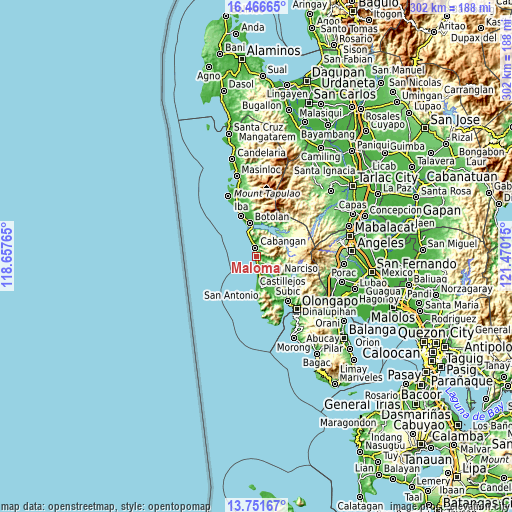
| \ | Map #1 | Map #2 | Topo.Map |
| Scale [m] | 0..485 m | 0..1064 m | × |
| Scale [ft] | 0..1591 ft | 0..3491 ft | × |
| Average | 88.4 m = 290 ft | 162.4 m = 533 ft | × |
| Width | 9.43 km = 5.9 mi | 18.87 km = 11.7 mi | 301.9 km = 187.6 mi |
| Height | 9.43 km = 5.9 mi | 18.87 km = 11.7 mi | 301.9 km = 187.6 mi |
| ↑Max Latitude | 15.155921° | 15.198334° | 16.46665° |
| Latitude at center | 15.1135° | 15.1135° | 15.1135° |
| ↓Min Latitude | 15.07107° | 15.028632° | 13.75167° |
| ← Min Longitude | 120.019955° | 119.976009° | 118.65765° |
| Longitude center | 120.0639° | 120.0639° | 120.0639° |
| →Max Longitude | 120.107845° | 120.151791° | 121.47015° |
Nearby cities:
Cities around Maloma sort by population:
• San Antonio elevation 16 m
18.7 km,  172°
172°
• Botolan 15 m
20 km,  347°
347°
• San Marcelino 45 m
18.5 km,  147°
147°
• San Narciso 16 m
11.2 km, 170°
• Poblacion, San Felipe 14 m
5.7 km, 173°
• San Juan 26 m
19.6 km,  0°
0°
• Cabangan 14 m
5 km, 351°
• San Nicolas 15 m
18.3 km,  175°
175°
• Beddeng 16 m
15.3 km, 171°
• Purac 14 m
16.2 km,  341°
341°
• Panan 14 m
11.8 km, 340°
• Santa Fe 80 m
19.5 km,  126°
126°
Multilingual:
 En español:
Maloma elevación 14 m.
 En France:
Maloma élévation 14 m.


Sources and notes:
- [note 1] Map square and city borders are not equal. Map elevation data is calculated only from area inside that square.
- [src 1] Elevation data from geonames database provided with same terms of usage.
- [src 2] The elevation map of Maloma is generated using elevation data from NASA's 3 arcsec (90m) resolution SRTM data.
- [src 3] Base (background) map © OpenStreetMap contributors tiles are generated by Geofabrik and OpenTopoMap.
Copyright & License:
This Maloma Elevation Map is licensed under CC BY-SA. You may reuse any part from this page, if you give a proper credit by linking to this URL:
 More info on terms of use page.