Mamala elevation
Mamala (Calabarzon, Province of Quezon), Philippines elevation is 616 meters and Mamala elevation in feet is 2021 ft above sea level [src 1]. Mamala is a populated place (feature code) with elevation that is 528 meters (1732 ft) bigger than average city elevation in Philippines.
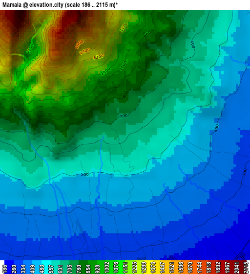
Below is the Elevation map of Mamala, which displays elevation range with different colors. Scale of the first map is from 186 to 2115 m (610 to 6939 ft) with average elevation of 658.4 meters (=2160 ft) [note 1]
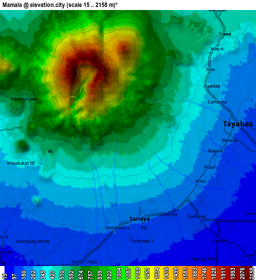
These maps also provides idea of topography and contour of this city, they are displayed at different zoom levels. More info about maps, scale and edge coordinates you can find below images.
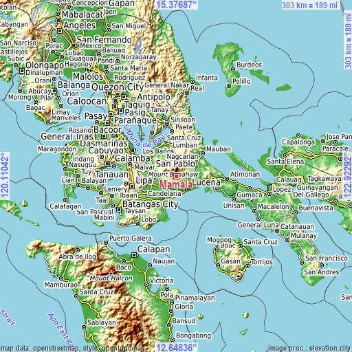
| \ | Map #1 | Map #2 | Topo.Map |
| Scale [m] | 186..2115 m | 15..2158 m | × |
| Scale [ft] | 610..6939 ft | 49..7080 ft | × |
| Average | 658.4 m = 2160 ft | 507.1 m = 1664 ft | × |
| Width | 9.48 km = 5.9 mi | 18.96 km = 11.8 mi | 303.4 km = 188.5 mi |
| Height | 9.48 km = 5.9 mi | 18.96 km = 11.8 mi | 303.4 km = 188.5 mi |
| ↑Max Latitude | 14.059303° | 14.101928° | 15.37687° |
| Latitude at center | 14.01667° | 14.01667° | 14.01667° |
| ↓Min Latitude | 13.974029° | 13.93138° | 12.64836° |
| ← Min Longitude | 121.472725° | 121.428779° | 120.11042° |
| Longitude center | 121.51667° | 121.51667° | 121.51667° |
| →Max Longitude | 121.560615° | 121.604561° | 122.92292° |
Nearby cities:
Cities around Mamala sort by population:
• Sariaya elevation 197 m
6.1 km,  170°
170°
• Tayabas 194 m
8.3 km,  82°
82°
• Lucban 431 m
11.6 km,  21°
21°
• Concepcion Ibaba 83 m
12 km,  210°
210°
• Malabanban Norte 102 m
12.2 km,  229°
229°
• Masalukot Uno 113 m
12.6 km,  237°
237°
• Dolores 291 m
11.5 km,  273°
273°
• Janagdong 51 m
12.6 km,  181°
181°
• Santa Lucia 463 m
9.4 km,  282°
282°
• Isabang 98 m
8.8 km,  138°
138°
• Bukal 55 m
11.6 km, 174°
• Calumpang 298 m
4.6 km,  130°
130°
Multilingual:
 En español:
Mamala elevación 616 m.
 En France:
Mamala élévation 616 m.


Sources and notes:
- [note 1] Map square and city borders are not equal. Map elevation data is calculated only from area inside that square.
- [src 1] Elevation data from geonames database provided with same terms of usage.
- [src 2] The elevation map of Mamala is generated using elevation data from NASA's 3 arcsec (90m) resolution SRTM data.
- [src 3] Base (background) map © OpenStreetMap contributors tiles are generated by Geofabrik and OpenTopoMap.
Copyright & License:
This Mamala Elevation Map is licensed under CC BY-SA. You may reuse any part from this page, if you give a proper credit by linking to this URL:
 More info on terms of use page.