Manga elevation
Manga (Cagayan Valley, Province of Cagayan), Philippines elevation is 73 meters and Manga elevation in feet is 240 ft above sea level [src 1]. Manga is a populated place (feature code) with elevation that is 15 meters (49 ft) smaller than average city elevation in Philippines.
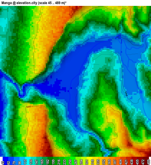
Below is the Elevation map of Manga, which displays elevation range with different colors. Scale of the first map is from 45 to 489 m (148 to 1604 ft) with average elevation of 197 meters (=646 ft) [note 1]
These maps also provides idea of topography and contour of this city, they are displayed at different zoom levels. More info about maps, scale and edge coordinates you can find below images.
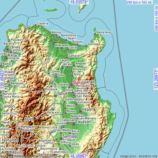
| \ | Map #1 | Topo.Map |
| Scale [m] | 45..489 m | × |
| Scale [ft] | 148..1604 ft | × |
| Average | 197 m = 646 ft | × |
| Width | 9.31 km = 5.8 mi | 297.9 km = 185.1 mi |
| Height | 9.31 km = 5.8 mi | 297.9 km = 185.1 mi |
| ↑Max Latitude | 17.74309° | 19.03579° |
| Latitude at center | 17.70123° | 17.70123° |
| ↓Min Latitude | 17.65936° | 16.35667° |
| ← Min Longitude | 121.816535° | 120.45423° |
| Longitude center | 121.86048° | 121.86048° |
| →Max Longitude | 121.904425° | 123.26673° |
Nearby cities:
Cities around Manga sort by population:
• Nattapian elevation 25 m
16.9 km,  260°
260°
• Dassun 23 m
16.5 km,  287°
287°
• Iguig 28 m
14.2 km, 292°
• Larion Alto 28 m
13.2 km,  233°
233°
• Dodan 37 m
9.7 km, 226°
• Peñablanca 53 m
11.3 km, 228°
• Carig 19 m
13.2 km,  249°
249°
• Lapi 96 m
4.3 km,  67°
67°
• Gammad 29 m
12.4 km,  274°
274°
• Quibal 68 m
5.5 km, 287°
• Aggugaddah 46 m
6.1 km, 268°
• Minanga Norte 24 m
15.4 km,  295°
295°
Multilingual:
 En español:
Manga elevación 73 m.
 En France:
Manga élévation 73 m.


Sources and notes:
- [note 1] Map square and city borders are not equal. Map elevation data is calculated only from area inside that square.
- [src 1] Elevation data from geonames database provided with same terms of usage.
- [src 2] The elevation map of Manga is generated using elevation data from NASA's 3 arcsec (90m) resolution SRTM data.
- [src 3] Base (background) map © OpenStreetMap contributors tiles are generated by Geofabrik and OpenTopoMap.
Copyright & License:
This Manga Elevation Map is licensed under CC BY-SA. You may reuse any part from this page, if you give a proper credit by linking to this URL:
 More info on terms of use page.