Manolo Fortich elevation
Manolo Fortich (Northern Mindanao, Province of Bukidnon), Philippines elevation is 515 meters and Manolo Fortich elevation in feet is 1690 ft above sea level [src 1]. Manolo Fortich is a seat of a third-order administrative division (feature code) with elevation that is 427 meters (1401 ft) bigger than average city elevation in Philippines.
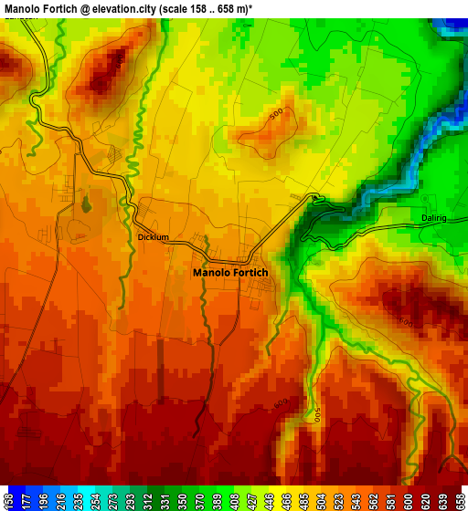
Below is the Elevation map of Manolo Fortich, which displays elevation range with different colors. Scale of the first map is from 158 to 658 m (518 to 2159 ft) with average elevation of 507.4 meters (=1665 ft) [note 1]
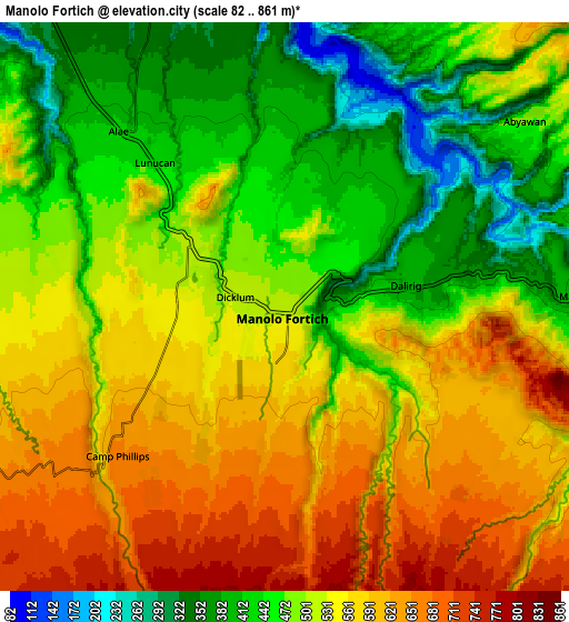
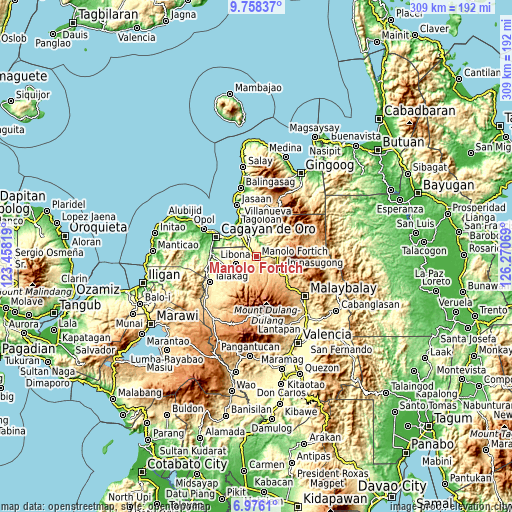
These maps also provides idea of topography and contour of this city, they are displayed at different zoom levels. More info about maps, scale and edge coordinates you can find below images.
| \ | Map #1 | Map #2 | Topo.Map |
| Scale [m] | 158..658 m | 82..861 m | × |
| Scale [ft] | 518..2159 ft | 269..2825 ft | × |
| Average | 507.4 m = 1665 ft | 519.1 m = 1703 ft | × |
| Width | 9.67 km = 6 mi | 19.34 km = 12 mi | 309.4 km = 192.3 mi |
| Height | 9.67 km = 6 mi | 19.34 km = 12 mi | 309.4 km = 192.3 mi |
| ↑Max Latitude | 8.413195° | 8.456665° | 9.75837° |
| Latitude at center | 8.36972° | 8.36972° | 8.36972° |
| ↓Min Latitude | 8.32624° | 8.282756° | 6.9761° |
| ← Min Longitude | 124.820495° | 124.776549° | 123.45819° |
| Longitude center | 124.86444° | 124.86444° | 124.86444° |
| →Max Longitude | 124.908385° | 124.952331° | 126.27069° |
Nearby cities:
Cities around Manolo Fortich sort by population:
• Damilag elevation 577 m
6 km,  253°
253°
• Kisolon 536 m
13.1 km,  109°
109°
• Libona 576 m
14.6 km,  256°
256°
• Sumilao 728 m
12.8 km,  135°
135°
• Alae 420 m
8.3 km,  316°
316°
• Dalirig 399 m
4.1 km,  78°
78°
• Santa Fe 607 m
9.7 km, 251°
• Maluko 417 m
9.9 km,  86°
86°
• Sankanan 686 m
6.1 km,  186°
186°
• Mambatangan 382 m
7.9 km,  334°
334°
• Kalugmanan 828 m
10.2 km,  182°
182°
• Pontian 786 m
10.6 km,  158°
158°
Multilingual:
 En español:
Maluko elevación 515 m.
 En France:
Manolo Fortich élévation 515 m.
 Auf Deutsch:
Manolo Fortich höhe über dem Meeresspiegel ist 515 m.

Sources and notes:
- [note 1] Map square and city borders are not equal. Map elevation data is calculated only from area inside that square.
- [src 1] Elevation data from geonames database provided with same terms of usage.
- [src 2] The elevation map of Manolo Fortich is generated using elevation data from NASA's 3 arcsec (90m) resolution SRTM data.
- [src 3] Base (background) map © OpenStreetMap contributors tiles are generated by Geofabrik and OpenTopoMap.
Copyright & License:
This Manolo Fortich Elevation Map is licensed under CC BY-SA. You may reuse any part from this page, if you give a proper credit by linking to this URL:
 More info on terms of use page.