Masaya elevation
Masaya (Calabarzon, Province of Laguna), Philippines elevation is 21 meters and Masaya elevation in feet is 69 ft above sea level [src 1]. Masaya is a section of populated place (feature code) with elevation that is 67 meters (220 ft) smaller than average city elevation in Philippines.
Below is the Elevation map of Masaya, which displays elevation range with different colors. Scale of the first map is from 0 to 463 m (0 to 1519 ft) with average elevation of 53.8 meters (=177 ft) [note 1]
These maps also provides idea of topography and contour of this city, they are displayed at different zoom levels. More info about maps, scale and edge coordinates you can find below images.
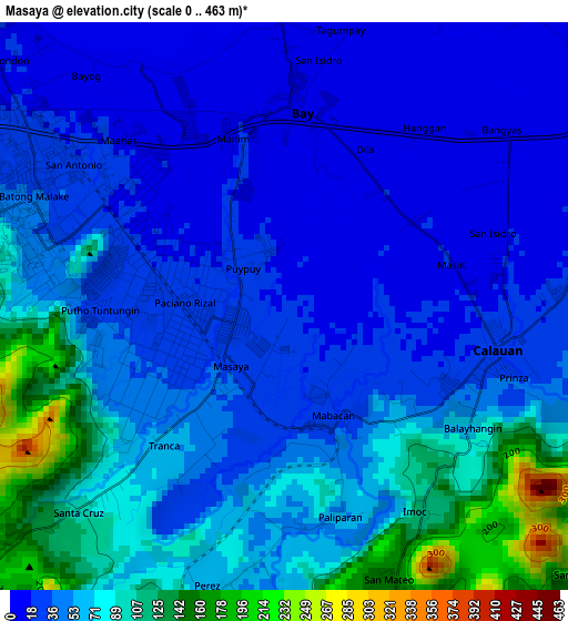
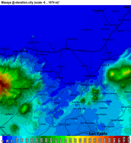
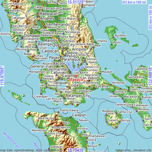
| \ | Map #1 | Map #2 | Topo.Map |
| Scale [m] | 0..463 m | -6..1074 m | × |
| Scale [ft] | 0..1519 ft | -20..3524 ft | × |
| Average | 53.8 m = 177 ft | 109.4 m = 359 ft | × |
| Width | 9.48 km = 5.9 mi | 18.95 km = 11.8 mi | 303.2 km = 188.4 mi |
| Height | 9.48 km = 5.9 mi | 18.95 km = 11.8 mi | 303.2 km = 188.4 mi |
| ↑Max Latitude | 14.194498° | 14.237097° | 15.51125° |
| Latitude at center | 14.15189° | 14.15189° | 14.15189° |
| ↓Min Latitude | 14.109274° | 14.066651° | 12.78435° |
| ← Min Longitude | 121.237955° | 121.194009° | 119.87565° |
| Longitude center | 121.2819° | 121.2819° | 121.2819° |
| →Max Longitude | 121.325845° | 121.369791° | 122.68815° |
Nearby cities:
Cities around Masaya sort by population:
• San Pablo elevation 115 m
10.4 km,  153°
153°
• Los Baños 32 m
4.8 km,  295°
295°
• Calauan 18 m
3.6 km,  93°
93°
• Bay 11 m
3.6 km,  6°
6°
• Alaminos 152 m
10.5 km,  201°
201°
• Victoria 14 m
9.9 km,  31°
31°
• Bitin 323 m
7.6 km,  238°
238°
• Dayap 13 m
6.4 km,  60°
60°
• Masapang 14 m
8.2 km,  52°
52°
• Santa Cruz 55 m
3.9 km,  177°
177°
• Santa Catalina 123 m
7.3 km,  117°
117°
• Hanggan 5 m
4.5 km, 25°
Multilingual:
 En español:
Masaya elevación 21 m.
 En France:
Masaya élévation 21 m.


Sources and notes:
- [note 1] Map square and city borders are not equal. Map elevation data is calculated only from area inside that square.
- [src 1] Elevation data from geonames database provided with same terms of usage.
- [src 2] The elevation map of Masaya is generated using elevation data from NASA's 3 arcsec (90m) resolution SRTM data.
- [src 3] Base (background) map © OpenStreetMap contributors tiles are generated by Geofabrik and OpenTopoMap.
Copyright & License:
This Masaya Elevation Map is licensed under CC BY-SA. You may reuse any part from this page, if you give a proper credit by linking to this URL:
 More info on terms of use page.