Morong elevation
Morong (Central Luzon, Province of Bataan), Philippines elevation is 10 meters and Morong elevation in feet is 33 ft above sea level [src 1]. Morong is a seat of a third-order administrative division (feature code) with elevation that is 78 meters (256 ft) smaller than average city elevation in Philippines.
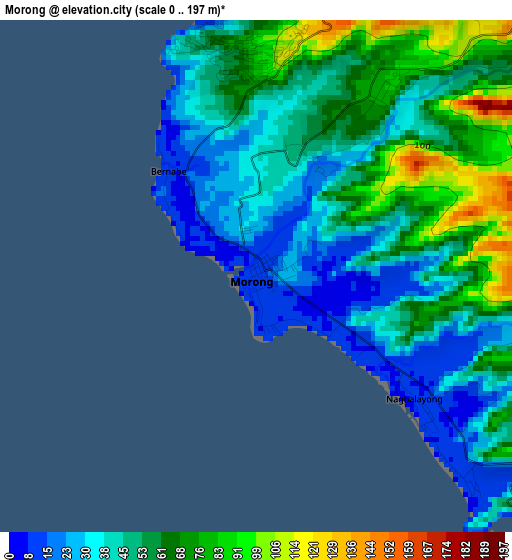
Below is the Elevation map of Morong, which displays elevation range with different colors. Scale of the first map is from 0 to 197 m (0 to 646 ft) with average elevation of 51.3 meters (=168 ft) [note 1]
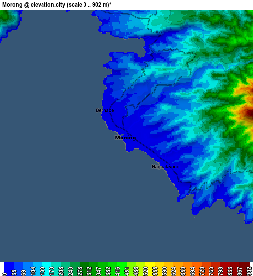
These maps also provides idea of topography and contour of this city, they are displayed at different zoom levels. More info about maps, scale and edge coordinates you can find below images.
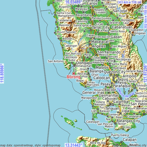
| \ | Map #1 | Map #2 | Topo.Map |
| Scale [m] | 0..197 m | 0..902 m | × |
| Scale [ft] | 0..646 ft | 0..2959 ft | × |
| Average | 51.3 m = 168 ft | 151.6 m = 497 ft | × |
| Width | 9.45 km = 5.9 mi | 18.91 km = 11.8 mi | 302.5 km = 188 mi |
| Height | 9.45 km = 5.9 mi | 18.91 km = 11.8 mi | 302.5 km = 188 mi |
| ↑Max Latitude | 14.721397° | 14.763895° | 16.03489° |
| Latitude at center | 14.67889° | 14.67889° | 14.67889° |
| ↓Min Latitude | 14.636375° | 14.593852° | 13.31443° |
| ← Min Longitude | 120.222165° | 120.178219° | 118.85986° |
| Longitude center | 120.26611° | 120.26611° | 120.26611° |
| →Max Longitude | 120.310055° | 120.354001° | 121.67236° |
Nearby cities:
Cities around Morong sort by population:
• Olongapo elevation 11 m
16.8 km,  6°
6°
• Balanga 12 m
29 km,  90°
90°
• Subic 1 m
22.5 km,  350°
350°
• Sabang 13 m
2.4 km,  317°
317°
• Bagac 18 m
16.4 km,  124°
124°
• Pamatawan 52 m
28.2 km, 348°
• Mabayo 10 m
6 km, 12°
• Parang 175 m
20.4 km,  104°
104°
• Saysain 8 m
18.9 km,  133°
133°
• San Benito 20 m
25.8 km,  42°
42°
• Banawang 25 m
15.3 km, 119°
• Subic Bay Freeport Zone 118 m
12.3 km, 6°
Multilingual:
 En español:
Morong elevación 10 m.
 En France:
Morong élévation 10 m.


Sources and notes:
- [note 1] Map square and city borders are not equal. Map elevation data is calculated only from area inside that square.
- [src 1] Elevation data from geonames database provided with same terms of usage.
- [src 2] The elevation map of Morong is generated using elevation data from NASA's 3 arcsec (90m) resolution SRTM data.
- [src 3] Base (background) map © OpenStreetMap contributors tiles are generated by Geofabrik and OpenTopoMap.
Copyright & License:
This Morong Elevation Map is licensed under CC BY-SA. You may reuse any part from this page, if you give a proper credit by linking to this URL:
 More info on terms of use page.