Nangka elevation
Nangka (Central Visayas, Province of Negros Oriental), Philippines elevation is 13 meters and Nangka elevation in feet is 43 ft above sea level [src 1]. Nangka is a populated place (feature code) with elevation that is 75 meters (246 ft) smaller than average city elevation in Philippines.
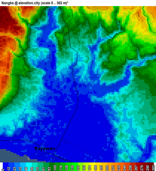
Below is the Elevation map of Nangka, which displays elevation range with different colors. Scale of the first map is from 0 to 302 m (0 to 991 ft) with average elevation of 71.5 meters (=235 ft) [note 1]
These maps also provides idea of topography and contour of this city, they are displayed at different zoom levels. More info about maps, scale and edge coordinates you can find below images.
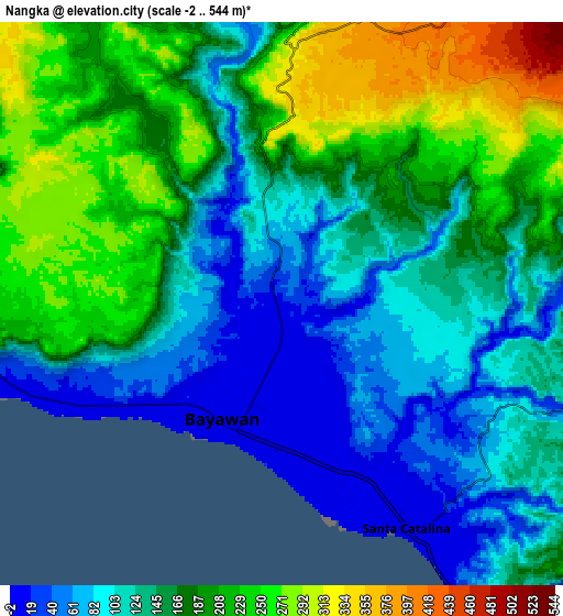
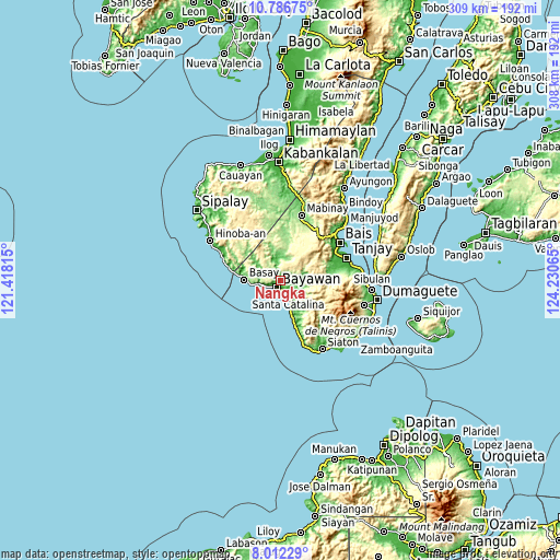
| \ | Map #1 | Map #2 | Topo.Map |
| Scale [m] | 0..302 m | -2..544 m | × |
| Scale [ft] | 0..991 ft | -7..1785 ft | × |
| Average | 71.5 m = 235 ft | 157.8 m = 518 ft | × |
| Width | 9.64 km = 6 mi | 19.28 km = 12 mi | 308.5 km = 191.7 mi |
| Height | 9.64 km = 6 mi | 19.28 km = 12 mi | 308.5 km = 191.7 mi |
| ↑Max Latitude | 9.445652° | 9.488999° | 10.78675° |
| Latitude at center | 9.4023° | 9.4023° | 9.4023° |
| ↓Min Latitude | 9.358942° | 9.315579° | 8.01229° |
| ← Min Longitude | 122.780455° | 122.736509° | 121.41815° |
| Longitude center | 122.8244° | 122.8244° | 122.8244° |
| →Max Longitude | 122.868345° | 122.912291° | 124.23065° |
Nearby cities:
Cities around Nangka sort by population:
• Bayawan elevation 10 m
4.7 km,  208°
208°
• Santa Catalina 14 m
8.8 km,  150°
150°
• Manalongon 16 m
21.3 km,  161°
161°
• Maninihon 12 m
3.9 km, 153°
• Tabuan 107 m
12.9 km,  12°
12°
• Nagbalaye 24 m
17.9 km, 161°
• Malabugas 11 m
7 km,  238°
238°
• Alangilan 14 m
14.9 km, 156°
• Basay 11 m
20.2 km,  272°
272°
• Bal-os 18 m
22.2 km,  281°
281°
• Amio 191 m
13.8 km,  111°
111°
• Apoya 123 m
22.1 km, 156°
Multilingual:
 En español:
Nangka elevación 13 m.
 En France:
Nangka élévation 13 m.


Sources and notes:
- [note 1] Map square and city borders are not equal. Map elevation data is calculated only from area inside that square.
- [src 1] Elevation data from geonames database provided with same terms of usage.
- [src 2] The elevation map of Nangka is generated using elevation data from NASA's 3 arcsec (90m) resolution SRTM data.
- [src 3] Base (background) map © OpenStreetMap contributors tiles are generated by Geofabrik and OpenTopoMap.
Copyright & License:
This Nangka Elevation Map is licensed under CC BY-SA. You may reuse any part from this page, if you give a proper credit by linking to this URL:
 More info on terms of use page.