Obong elevation
Obong (Central Visayas, Province of Cebu), Philippines elevation is 26 meters and Obong elevation in feet is 85 ft above sea level [src 1]. Obong is a populated place (feature code) with elevation that is 62 meters (203 ft) smaller than average city elevation in Philippines.
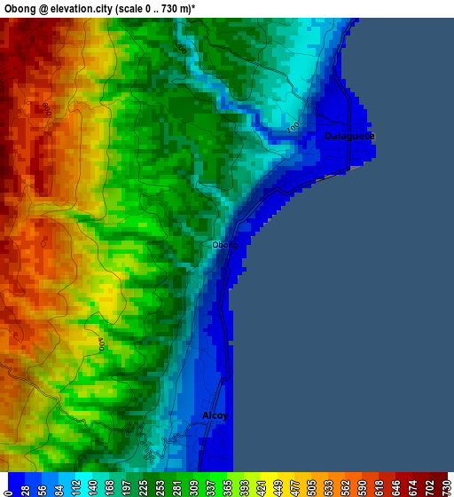
Below is the Elevation map of Obong, which displays elevation range with different colors. Scale of the first map is from 0 to 730 m (0 to 2395 ft) with average elevation of 306.5 meters (=1006 ft) [note 1]
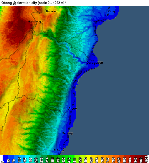
These maps also provides idea of topography and contour of this city, they are displayed at different zoom levels. More info about maps, scale and edge coordinates you can find below images.
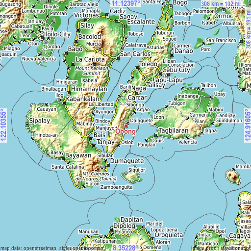
| \ | Map #1 | Map #2 | Topo.Map |
| Scale [m] | 0..730 m | 0..1022 m | × |
| Scale [ft] | 0..2395 ft | 0..3353 ft | × |
| Average | 306.5 m = 1006 ft | 476.8 m = 1564 ft | × |
| Width | 9.63 km = 6 mi | 19.26 km = 12 mi | 308.2 km = 191.5 mi |
| Height | 9.63 km = 6 mi | 19.26 km = 12 mi | 308.2 km = 191.5 mi |
| ↑Max Latitude | 9.784309° | 9.827612° | 11.12397° |
| Latitude at center | 9.741° | 9.741° | 9.741° |
| ↓Min Latitude | 9.697685° | 9.654365° | 8.35228° |
| ← Min Longitude | 123.465855° | 123.421909° | 122.10355° |
| Longitude center | 123.5098° | 123.5098° | 123.5098° |
| →Max Longitude | 123.553745° | 123.597691° | 124.91605° |
Nearby cities:
Cities around Obong sort by population:
• Dalaguete elevation 9 m
3.6 km,  50°
50°
• Mantalongon 779 m
9.4 km,  325°
325°
• Casay 45 m
9.8 km,  26°
26°
• Boljoon 12 m
13 km,  195°
195°
• Tabon 942 m
9.2 km,  320°
320°
• Alcoy 35 m
3.4 km,  185°
185°
• Guadalupe 681 m
12 km,  260°
260°
• Nugas 688 m
9 km,  236°
236°
• El Pardo 23 m
9.2 km, 190°
• Cawayan 15 m
7.4 km,  19°
19°
• Becerril 586 m
12.8 km,  220°
220°
• Tapon 72 m
3.9 km, 28°
Multilingual:
 En español:
Obong elevación 26 m.
 En France:
Obong élévation 26 m.


Sources and notes:
- [note 1] Map square and city borders are not equal. Map elevation data is calculated only from area inside that square.
- [src 1] Elevation data from geonames database provided with same terms of usage.
- [src 2] The elevation map of Obong is generated using elevation data from NASA's 3 arcsec (90m) resolution SRTM data.
- [src 3] Base (background) map © OpenStreetMap contributors tiles are generated by Geofabrik and OpenTopoMap.
Copyright & License:
This Obong Elevation Map is licensed under CC BY-SA. You may reuse any part from this page, if you give a proper credit by linking to this URL:
 More info on terms of use page.