Paatan elevation
Paatan (Soccsksargen, Province of Cotabato), Philippines elevation is 54 meters and Paatan elevation in feet is 177 ft above sea level [src 1]. Paatan is a populated place (feature code) with elevation that is 34 meters (112 ft) smaller than average city elevation in Philippines.
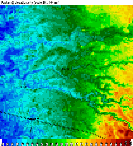
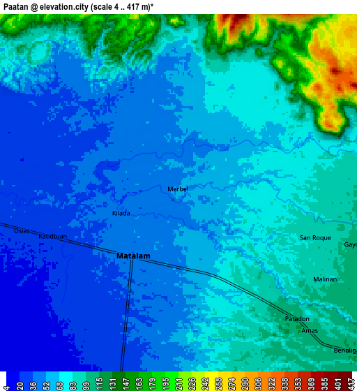
Below is the Elevation map of Paatan, which displays elevation range with different colors. Scale of the first map is from 28 to 104 m (92 to 341 ft) with average elevation of 52.3 meters (=172 ft) [note 1]
These maps also provides idea of topography and contour of this city, they are displayed at different zoom levels. More info about maps, scale and edge coordinates you can find below images.
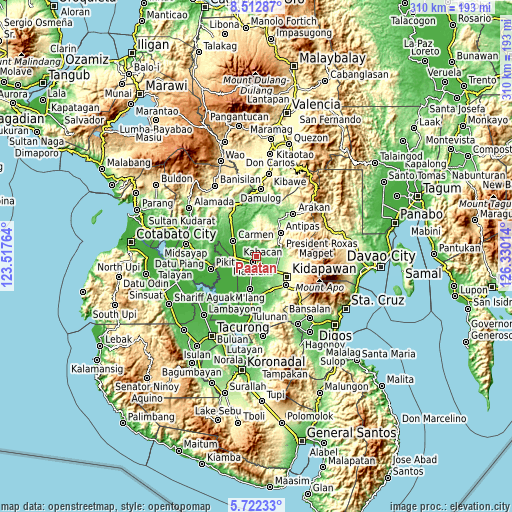
| \ | Map #1 | Map #2 | Topo.Map |
| Scale [m] | 28..104 m | 4..417 m | × |
| Scale [ft] | 92..341 ft | 13..1368 ft | × |
| Average | 52.3 m = 172 ft | 74.7 m = 245 ft | × |
| Width | 9.7 km = 6 mi | 19.39 km = 12 mi | 310.3 km = 192.8 mi |
| Height | 9.7 km = 6 mi | 19.39 km = 12 mi | 310.3 km = 192.8 mi |
| ↑Max Latitude | 7.163324° | 7.206925° | 8.51287° |
| Latitude at center | 7.11972° | 7.11972° | 7.11972° |
| ↓Min Latitude | 7.076111° | 7.032499° | 5.72233° |
| ← Min Longitude | 124.879945° | 124.835999° | 123.51764° |
| Longitude center | 124.92389° | 124.92389° | 124.92389° |
| →Max Longitude | 124.967835° | 125.011781° | 126.33014° |
Nearby cities:
Cities around Paatan sort by population:
• Kabacan elevation 24 m
10.6 km,  262°
262°
• Matalam 42 m
4.5 km,  214°
214°
• Amas 107 m
9.6 km,  136°
136°
• Linao 79 m
7.2 km,  41°
41°
• Marbel 46 m
1.3 km,  251°
251°
• Malapag 25 m
11.9 km,  277°
277°
• Labu-o 133 m
13.4 km,  92°
92°
• Malamote 73 m
5.4 km,  160°
160°
• Banawa 34 m
7.4 km,  300°
300°
• New Cebu 117 m
12.4 km,  102°
102°
• Limbalod 19 m
13.9 km, 276°
• Pedtad 26 m
12.9 km,  290°
290°
Multilingual:
 En español:
Paatan elevación 54 m.
 En France:
Paatan élévation 54 m.


Sources and notes:
- [note 1] Map square and city borders are not equal. Map elevation data is calculated only from area inside that square.
- [src 1] Elevation data from geonames database provided with same terms of usage.
- [src 2] The elevation map of Paatan is generated using elevation data from NASA's 3 arcsec (90m) resolution SRTM data.
- [src 3] Base (background) map © OpenStreetMap contributors tiles are generated by Geofabrik and OpenTopoMap.
Copyright & License:
This Paatan Elevation Map is licensed under CC BY-SA. You may reuse any part from this page, if you give a proper credit by linking to this URL:
 More info on terms of use page.