Pagadian elevation
Pagadian (Zamboanga Peninsula, Province of Zamboanga del Sur), Philippines elevation is 40 meters and Pagadian elevation in feet is 131 ft above sea level [src 1]. Pagadian is a seat of a first-order administrative division (feature code) with elevation that is 48 meters (157 ft) smaller than average city elevation in Philippines.
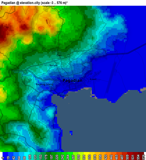
Below is the Elevation map of Pagadian, which displays elevation range with different colors. Scale of the first map is from -3 to 576 m (-10 to 1890 ft) with average elevation of 141.5 meters (=464 ft) [note 1]
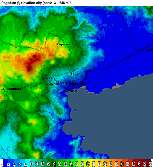
These maps also provides idea of topography and contour of this city, they are displayed at different zoom levels. More info about maps, scale and edge coordinates you can find below images.
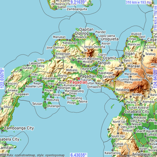
| \ | Map #1 | Map #2 | Topo.Map |
| Scale [m] | -3..576 m | -3..648 m | × |
| Scale [ft] | -10..1890 ft | -10..2126 ft | × |
| Average | 141.5 m = 464 ft | 158.5 m = 520 ft | × |
| Width | 9.68 km = 6 mi | 19.36 km = 12 mi | 309.8 km = 192.5 mi |
| Height | 9.68 km = 6 mi | 19.36 km = 12 mi | 309.8 km = 192.5 mi |
| ↑Max Latitude | 7.869234° | 7.912763° | 9.21639° |
| Latitude at center | 7.8257° | 7.8257° | 7.8257° |
| ↓Min Latitude | 7.782162° | 7.738619° | 6.43035° |
| ← Min Longitude | 123.393055° | 123.349109° | 122.03075° |
| Longitude center | 123.437° | 123.437° | 123.437° |
| →Max Longitude | 123.480945° | 123.524891° | 124.84325° |
Nearby cities:
Cities around Pagadian sort by population:
• Muricay elevation 3 m
4.5 km,  87°
87°
• Tucuran 7 m
15.4 km,  78°
78°
• Labangan 8 m
9.4 km,  61°
61°
• Guipos 249 m
17.6 km,  226°
226°
• Dumalinao 239 m
7.5 km,  264°
264°
• San Pablo 17 m
19 km,  172°
172°
• Tawagan 7 m
4.7 km, 63°
• Danlugan 251 m
10.2 km,  315°
315°
• Robonkon 6 m
8.3 km,  194°
194°
• Kagawasan 374 m
6.4 km,  314°
314°
• Guiniculalay 185 m
19.5 km, 194°
• Sagacad 225 m
18.8 km,  214°
214°
Multilingual:
 En español:
Pagadian elevación 40 m.
 En France:
Pagadian élévation 40 m.


Sources and notes:
- [note 1] Map square and city borders are not equal. Map elevation data is calculated only from area inside that square.
- [src 1] Elevation data from geonames database provided with same terms of usage.
- [src 2] The elevation map of Pagadian is generated using elevation data from NASA's 3 arcsec (90m) resolution SRTM data.
- [src 3] Base (background) map © OpenStreetMap contributors tiles are generated by Geofabrik and OpenTopoMap.
Copyright & License:
This Pagadian Elevation Map is licensed under CC BY-SA. You may reuse any part from this page, if you give a proper credit by linking to this URL:
 More info on terms of use page.