Pangian elevation
Pangian (Davao, Davao Occidental), Philippines elevation is 67 meters and Pangian elevation in feet is 220 ft above sea level [src 1]. Pangian is a populated place (feature code) with elevation that is 21 meters (69 ft) smaller than average city elevation in Philippines.
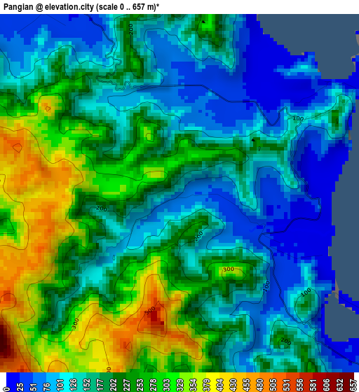
Below is the Elevation map of Pangian, which displays elevation range with different colors. Scale of the first map is from 0 to 657 m (0 to 2156 ft) with average elevation of 192.6 meters (=632 ft) [note 1]
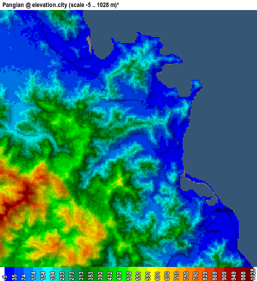
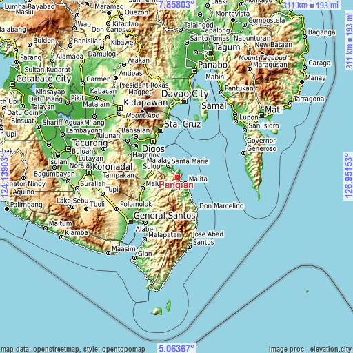
These maps also provides idea of topography and contour of this city, they are displayed at different zoom levels. More info about maps, scale and edge coordinates you can find below images.
| \ | Map #1 | Map #2 | Topo.Map |
| Scale [m] | 0..657 m | -5..1028 m | × |
| Scale [ft] | 0..2156 ft | -16..3373 ft | × |
| Average | 192.6 m = 632 ft | 259.8 m = 852 ft | × |
| Width | 9.71 km = 6 mi | 19.42 km = 12.1 mi | 310.7 km = 193.1 mi |
| Height | 9.71 km = 6 mi | 19.42 km = 12.1 mi | 310.7 km = 193.1 mi |
| ↑Max Latitude | 6.506444° | 6.550105° | 7.85803° |
| Latitude at center | 6.46278° | 6.46278° | 6.46278° |
| ↓Min Latitude | 6.419112° | 6.37544° | 5.06367° |
| ← Min Longitude | 125.501335° | 125.457389° | 124.13903° |
| Longitude center | 125.54528° | 125.54528° | 125.54528° |
| →Max Longitude | 125.589225° | 125.633171° | 126.95153° |
Nearby cities:
Cities around Pangian sort by population:
• Malita elevation 8 m
9.1 km,  125°
125°
• Santa Maria 19 m
13 km,  320°
320°
• Basiawan 27 m
10.2 km, 320°
• Kinangan 108 m
18.5 km,  166°
166°
• Bulacan 30 m
18 km,  310°
310°
• Buhangin 46 m
3.2 km,  4°
4°
• Tubalan 16 m
4.3 km,  32°
32°
• Pung-Pang 93 m
9.8 km,  293°
293°
• Lacaron 12 m
4.1 km,  112°
112°
• Lais 14 m
18.3 km,  142°
142°
• Tanlad 11 m
19.1 km, 324°
• Bolila 69 m
10.5 km,  164°
164°
Multilingual:
 En español:
Pangian elevación 67 m.
 En France:
Pangian élévation 67 m.


Sources and notes:
- [note 1] Map square and city borders are not equal. Map elevation data is calculated only from area inside that square.
- [src 1] Elevation data from geonames database provided with same terms of usage.
- [src 2] The elevation map of Pangian is generated using elevation data from NASA's 3 arcsec (90m) resolution SRTM data.
- [src 3] Base (background) map © OpenStreetMap contributors tiles are generated by Geofabrik and OpenTopoMap.
Copyright & License:
This Pangian Elevation Map is licensed under CC BY-SA. You may reuse any part from this page, if you give a proper credit by linking to this URL:
 More info on terms of use page.