Pitogo elevation
Pitogo (Zamboanga Peninsula, Province of Zamboanga del Sur), Philippines elevation is 15 meters and Pitogo elevation in feet is 49 ft above sea level [src 1]. Pitogo is a populated place (feature code) with elevation that is 73 meters (240 ft) smaller than average city elevation in Philippines.
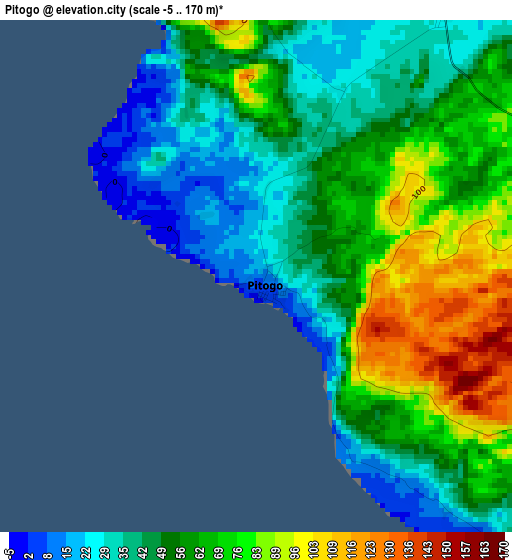
Below is the Elevation map of Pitogo, which displays elevation range with different colors. Scale of the first map is from -5 to 170 m (-16 to 558 ft) with average elevation of 56.7 meters (=186 ft) [note 1]
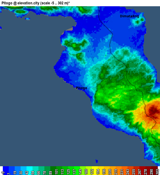
These maps also provides idea of topography and contour of this city, they are displayed at different zoom levels. More info about maps, scale and edge coordinates you can find below images.
| \ | Map #1 | Map #2 | Topo.Map |
| Scale [m] | -5..170 m | -5..302 m | × |
| Scale [ft] | -16..558 ft | -16..991 ft | × |
| Average | 56.7 m = 186 ft | 63.9 m = 210 ft | × |
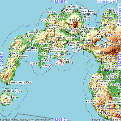
| Width | 9.69 km = 6 mi | 19.38 km = 12 mi | 310 km = 192.6 mi |
| Height | 9.69 km = 6 mi | 19.38 km = 12 mi | 310.1 km = 192.7 mi |
| ↑Max Latitude | 7.498172° | 7.541739° | 8.84661° |
| Latitude at center | 7.4546° | 7.4546° | 7.4546° |
| ↓Min Latitude | 7.411024° | 7.367444° | 6.05815° |
| ← Min Longitude | 123.267155° | 123.223209° | 121.90485° |
| Longitude center | 123.3111° | 123.3111° | 123.3111° |
| →Max Longitude | 123.355045° | 123.398991° | 124.71735° |
Nearby cities:
Cities around Pitogo sort by population:
• Margosatubig elevation 8 m
21.1 km,  310°
310°
• Tabina 1 m
10.8 km,  82°
82°
• Dimataling 8 m
11.2 km,  37°
37°
• Legrada 242 m
19.9 km,  357°
357°
• Kalian 361 m
17.6 km,  330°
330°
• East Migpulao 6 m
20.5 km,  14°
14°
• San Miguel 253 m
22.1 km,  347°
347°
• Malim 55 m
13.2 km,  91°
91°
• Binuatan 5 m
17.9 km, 11°
• Guiniculalay 185 m
24.1 km,  21°
21°
• Lumbog 214 m
16.7 km, 313°
• Panubigan 100 m
4.9 km,  126°
126°
Multilingual:
 En español:
Pitogo elevación 15 m.
 En France:
Pitogo élévation 15 m.


Sources and notes:
- [note 1] Map square and city borders are not equal. Map elevation data is calculated only from area inside that square.
- [src 1] Elevation data from geonames database provided with same terms of usage.
- [src 2] The elevation map of Pitogo is generated using elevation data from NASA's 3 arcsec (90m) resolution SRTM data.
- [src 3] Base (background) map © OpenStreetMap contributors tiles are generated by Geofabrik and OpenTopoMap.
Copyright & License:
This Pitogo Elevation Map is licensed under CC BY-SA. You may reuse any part from this page, if you give a proper credit by linking to this URL:
 More info on terms of use page.