Pulung Santol elevation
Pulung Santol (Central Luzon, Province of Pampanga), Philippines elevation is 60 meters and Pulung Santol elevation in feet is 197 ft above sea level [src 1]. Pulung Santol is a populated place (feature code) with elevation that is 28 meters (92 ft) smaller than average city elevation in Philippines.
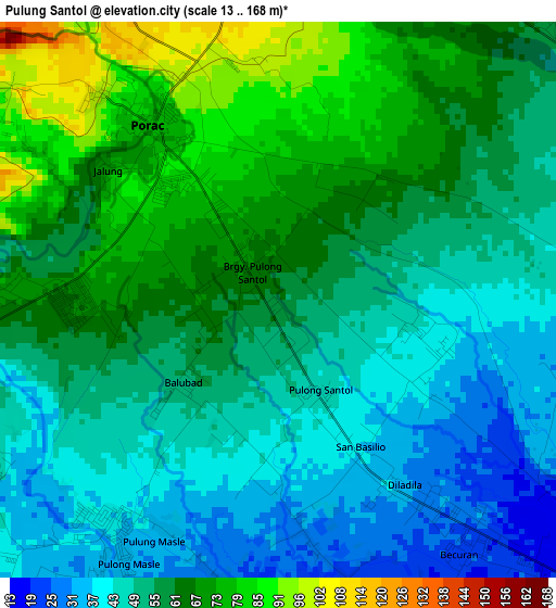
Below is the Elevation map of Pulung Santol, which displays elevation range with different colors. Scale of the first map is from 13 to 168 m (43 to 551 ft) with average elevation of 56.2 meters (=184 ft) [note 1]
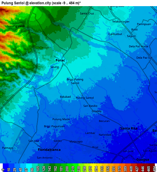
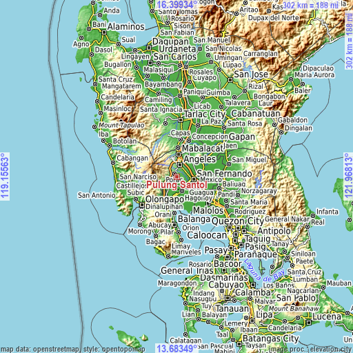
These maps also provides idea of topography and contour of this city, they are displayed at different zoom levels. More info about maps, scale and edge coordinates you can find below images.
| \ | Map #1 | Map #2 | Topo.Map |
| Scale [m] | 13..168 m | -9..484 m | × |
| Scale [ft] | 43..551 ft | -30..1588 ft | × |
| Average | 56.2 m = 184 ft | 71.1 m = 233 ft | × |
| Width | 9.44 km = 5.9 mi | 18.88 km = 11.7 mi | 302 km = 187.7 mi |
| Height | 9.44 km = 5.9 mi | 18.88 km = 11.7 mi | 302 km = 187.7 mi |
| ↑Max Latitude | 15.088175° | 15.130601° | 16.39934° |
| Latitude at center | 15.04574° | 15.04574° | 15.04574° |
| ↓Min Latitude | 15.003297° | 14.960845° | 13.68349° |
| ← Min Longitude | 120.517935° | 120.473989° | 119.15563° |
| Longitude center | 120.56188° | 120.56188° | 120.56188° |
| →Max Longitude | 120.605825° | 120.649771° | 121.96813° |
Nearby cities:
Cities around Pulung Santol sort by population:
• Manibaug Pasig elevation 91 m
5.6 km,  2°
2°
• Pio 67 m
4.6 km,  272°
272°
• Porac 73 m
3.5 km,  323°
323°
• Babo-Pangulo 124 m
6.4 km,  310°
310°
• Pulungmasle 25 m
5.1 km,  185°
185°
• San Basilio 39 m
2.8 km,  119°
119°
• Dolores 134 m
6.5 km,  327°
327°
• Calantas 45 m
5.6 km,  238°
238°
• Del Carmen 34 m
5.4 km,  213°
213°
• Pias 35 m
3.2 km,  179°
179°
• Balas 47 m
2.6 km,  79°
79°
• Maquiapo 22 m
6.7 km, 183°
Multilingual:
 En español:
Pulung Santol elevación 60 m.
 En France:
Pulung Santol élévation 60 m.
 Auf Deutsch:
Pulung Santol höhe über dem Meeresspiegel ist 60 m.

Sources and notes:
- [note 1] Map square and city borders are not equal. Map elevation data is calculated only from area inside that square.
- [src 1] Elevation data from geonames database provided with same terms of usage.
- [src 2] The elevation map of Pulung Santol is generated using elevation data from NASA's 3 arcsec (90m) resolution SRTM data.
- [src 3] Base (background) map © OpenStreetMap contributors tiles are generated by Geofabrik and OpenTopoMap.
Copyright & License:
This Pulung Santol Elevation Map is licensed under CC BY-SA. You may reuse any part from this page, if you give a proper credit by linking to this URL:
 More info on terms of use page.