Salvador elevation
Salvador (Soccsksargen), Philippines elevation is 34 meters and Salvador elevation in feet is 112 ft above sea level [src 1]. Salvador is a populated place (feature code) with elevation that is 54 meters (177 ft) smaller than average city elevation in Philippines.
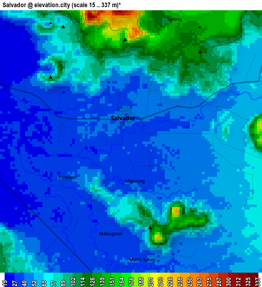
Below is the Elevation map of Salvador, which displays elevation range with different colors. Scale of the first map is from 15 to 337 m (49 to 1106 ft) with average elevation of 62.4 meters (=205 ft) [note 1]
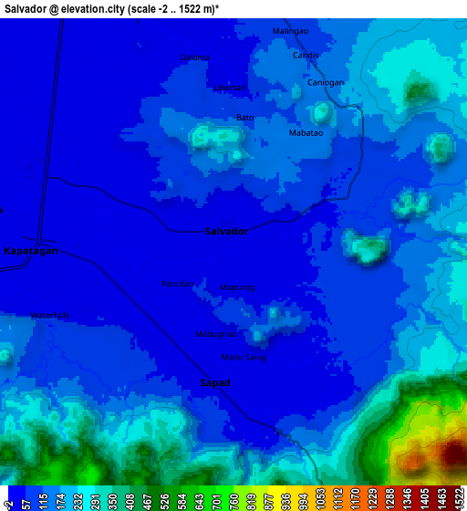
These maps also provides idea of topography and contour of this city, they are displayed at different zoom levels. More info about maps, scale and edge coordinates you can find below images.
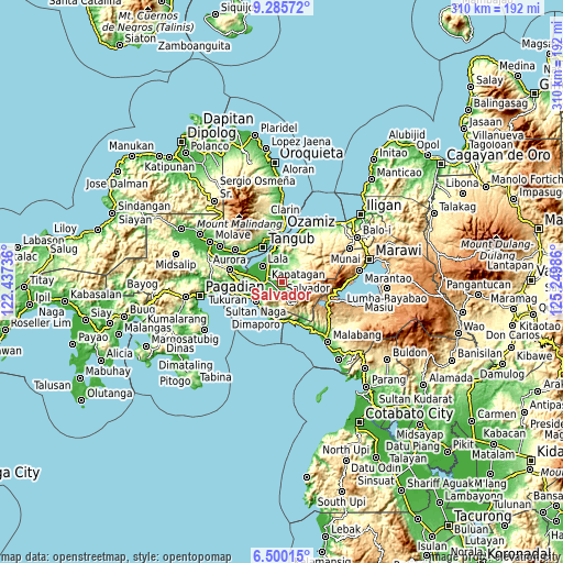
| \ | Map #1 | Map #2 | Topo.Map |
| Scale [m] | 15..337 m | -2..1522 m | × |
| Scale [ft] | 49..1106 ft | -7..4993 ft | × |
| Average | 62.4 m = 205 ft | 147.9 m = 485 ft | × |
| Width | 9.68 km = 6 mi | 19.36 km = 12 mi | 309.7 km = 192.4 mi |
| Height | 9.68 km = 6 mi | 19.36 km = 12 mi | 309.8 km = 192.5 mi |
| ↑Max Latitude | 7.938806° | 7.982328° | 9.28572° |
| Latitude at center | 7.89528° | 7.89528° | 7.89528° |
| ↓Min Latitude | 7.851749° | 7.808213° | 6.50015° |
| ← Min Longitude | 123.799665° | 123.755719° | 122.43736° |
| Longitude center | 123.84361° | 123.84361° | 123.84361° |
| →Max Longitude | 123.887555° | 123.931501° | 125.24986° |
Nearby cities:
Cities around Salvador sort by population:
• Maranding elevation 17 m
8.6 km,  292°
292°
• Kapatagan 18 m
8.2 km,  273°
273°
• Lala 8 m
13.7 km,  309°
309°
• Caromatan 6 m
18 km,  232°
232°
• Sapad 38 m
5.2 km,  192°
192°
• Rebe 34 m
3.4 km, 293°
• Lanipao 10 m
9.9 km, 312°
• Lapining 4 m
17.4 km,  280°
280°
• Baroy 9 m
16.3 km,  333°
333°
• Balili 23 m
12.1 km, 269°
• Panalo-on 12 m
10.6 km, 282°
• Pualas 44 m
13.6 km,  2°
2°
Multilingual:
 En español:
Salvador elevación 34 m.
 En France:
Salvador élévation 34 m.


Sources and notes:
- [note 1] Map square and city borders are not equal. Map elevation data is calculated only from area inside that square.
- [src 1] Elevation data from geonames database provided with same terms of usage.
- [src 2] The elevation map of Salvador is generated using elevation data from NASA's 3 arcsec (90m) resolution SRTM data.
- [src 3] Base (background) map © OpenStreetMap contributors tiles are generated by Geofabrik and OpenTopoMap.
Copyright & License:
This Salvador Elevation Map is licensed under CC BY-SA. You may reuse any part from this page, if you give a proper credit by linking to this URL:
 More info on terms of use page.