Sandiat Centro elevation
Sandiat Centro (Cagayan Valley, Province of Isabela), Philippines elevation is 59 meters and Sandiat Centro elevation in feet is 194 ft above sea level [src 1]. Sandiat Centro is a populated place (feature code) with elevation that is 29 meters (95 ft) smaller than average city elevation in Philippines.
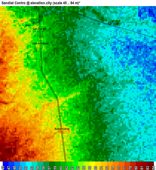
Below is the Elevation map of Sandiat Centro, which displays elevation range with different colors. Scale of the first map is from 45 to 84 m (148 to 276 ft) with average elevation of 60.2 meters (=198 ft) [note 1]
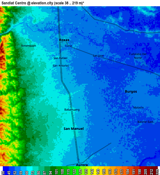
These maps also provides idea of topography and contour of this city, they are displayed at different zoom levels. More info about maps, scale and edge coordinates you can find below images.
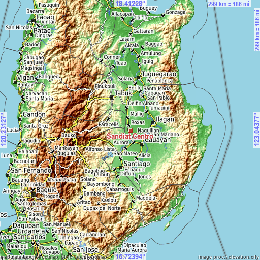
| \ | Map #1 | Map #2 | Topo.Map |
| Scale [m] | 45..84 m | 38..219 m | × |
| Scale [ft] | 148..276 ft | 125..719 ft | × |
| Average | 60.2 m = 198 ft | 68.5 m = 225 ft | × |
| Width | 9.34 km = 5.8 mi | 18.68 km = 11.6 mi | 298.9 km = 185.7 mi |
| Height | 9.34 km = 5.8 mi | 18.68 km = 11.6 mi | 298.9 km = 185.7 mi |
| ↑Max Latitude | 17.114954° | 17.156948° | 18.41228° |
| Latitude at center | 17.07295° | 17.07295° | 17.07295° |
| ↓Min Latitude | 17.030937° | 16.988914° | 15.72394° |
| ← Min Longitude | 121.593575° | 121.549629° | 120.23127° |
| Longitude center | 121.63752° | 121.63752° | 121.63752° |
| →Max Longitude | 121.681465° | 121.725411° | 123.04377° |
Nearby cities:
Cities around Sandiat Centro sort by population:
• Roxas elevation 60 m
5.4 km,  340°
340°
• San Manuel 64 m
5.5 km,  181°
181°
• Burgos 52 m
7.1 km,  75°
75°
• San Jose 65 m
9.4 km, 335°
• Muñoz East 65 m
9.7 km, 344°
• Cullalabo del Sur 55 m
7.8 km,  64°
64°
• Aurora 63 m
9.2 km, 180°
• Simimbaan 73 m
7.8 km,  310°
310°
• Bacnor East 51 m
8.2 km,  121°
121°
• Esperanza East 53 m
7.4 km,  138°
138°
• Eden 79 m
5.7 km,  227°
227°
• Quirino 47 m
9.4 km,  44°
44°
Multilingual:
 En español:
Sandiat Centro elevación 59 m.
 En France:
Sandiat Centro élévation 59 m.
 Auf Deutsch:
Sandiat Centro höhe über dem Meeresspiegel ist 59 m.

Sources and notes:
- [note 1] Map square and city borders are not equal. Map elevation data is calculated only from area inside that square.
- [src 1] Elevation data from geonames database provided with same terms of usage.
- [src 2] The elevation map of Sandiat Centro is generated using elevation data from NASA's 3 arcsec (90m) resolution SRTM data.
- [src 3] Base (background) map © OpenStreetMap contributors tiles are generated by Geofabrik and OpenTopoMap.
Copyright & License:
This Sandiat Centro Elevation Map is licensed under CC BY-SA. You may reuse any part from this page, if you give a proper credit by linking to this URL:
 More info on terms of use page.