San Fernando elevation
San Fernando (Bicol, Province of Masbate), Philippines elevation is 7 meters and San Fernando elevation in feet is 23 ft above sea level [src 1]. San Fernando is a seat of a third-order administrative division (feature code) with elevation that is 81 meters (266 ft) smaller than average city elevation in Philippines.
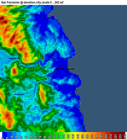
Below is the Elevation map of San Fernando, which displays elevation range with different colors. Scale of the first map is from 0 to 242 m (0 to 794 ft) with average elevation of 66 meters (=217 ft) [note 1]
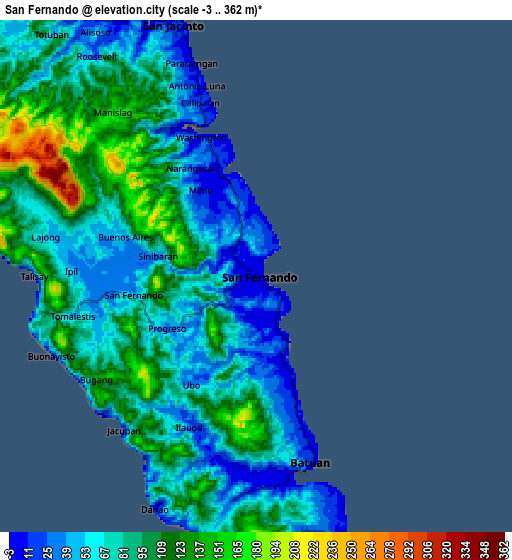
These maps also provides idea of topography and contour of this city, they are displayed at different zoom levels. More info about maps, scale and edge coordinates you can find below images.
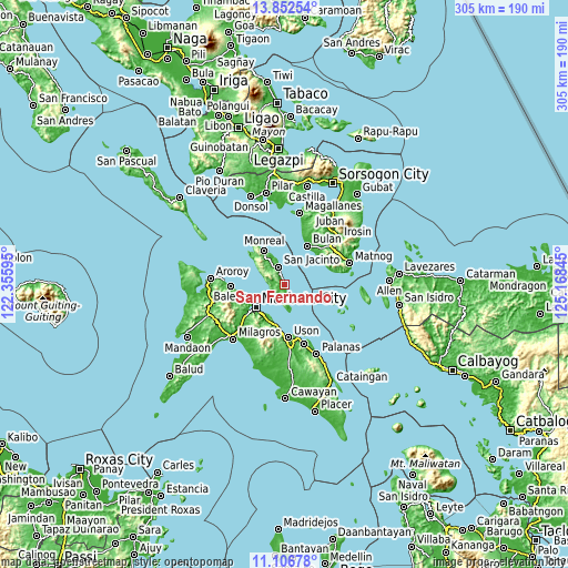
| \ | Map #1 | Map #2 | Topo.Map |
| Scale [m] | 0..242 m | -3..362 m | × |
| Scale [ft] | 0..794 ft | -10..1188 ft | × |
| Average | 66 m = 217 ft | 83.4 m = 274 ft | × |
| Width | 9.54 km = 5.9 mi | 19.08 km = 11.9 mi | 305.3 km = 189.7 mi |
| Height | 9.54 km = 5.9 mi | 19.08 km = 11.9 mi | 305.3 km = 189.7 mi |
| ↑Max Latitude | 12.526203° | 12.569099° | 13.85254° |
| Latitude at center | 12.4833° | 12.4833° | 12.4833° |
| ↓Min Latitude | 12.44039° | 12.397473° | 11.10678° |
| ← Min Longitude | 123.718255° | 123.674309° | 122.35595° |
| Longitude center | 123.7622° | 123.7622° | 123.7622° |
| →Max Longitude | 123.806145° | 123.850091° | 125.16845° |
Nearby cities:
Cities around San Fernando sort by population:
• Masbate elevation 12 m
19.4 km,  230°
230°
• San Jacinto 16 m
9.9 km,  341°
341°
• Monreal 8 m
20.8 km,  329°
329°
• Mobo 21 m
19.9 km,  214°
214°
• Umabay 16 m
21.3 km,  204°
204°
• Utabi 6 m
23.8 km,  42°
42°
• Bulo 7 m
22.7 km,  249°
249°
• Bagahanlad 58 m
14.8 km,  316°
316°
• Mayngaran 18 m
23.1 km, 229°
• Batuan 190 m
9.5 km,  179°
179°
• Luna 65 m
8 km, 337°
• Marintoc 7 m
22.4 km,  191°
191°
Multilingual:
 En español:
San Fernando elevación 7 m.
 En France:
San Fernando élévation 7 m.
 Auf Deutsch:
San Fernando höhe über dem Meeresspiegel ist 7 m.

Sources and notes:
- [note 1] Map square and city borders are not equal. Map elevation data is calculated only from area inside that square.
- [src 1] Elevation data from geonames database provided with same terms of usage.
- [src 2] The elevation map of San Fernando is generated using elevation data from NASA's 3 arcsec (90m) resolution SRTM data.
- [src 3] Base (background) map © OpenStreetMap contributors tiles are generated by Geofabrik and OpenTopoMap.
Copyright & License:
This San Fernando Elevation Map is licensed under CC BY-SA. You may reuse any part from this page, if you give a proper credit by linking to this URL:
 More info on terms of use page.