San Gabriel elevation
San Gabriel (Ilocos, Province of La Union), Philippines elevation is 23 meters and San Gabriel elevation in feet is 75 ft above sea level [src 1]. San Gabriel is a seat of a third-order administrative division (feature code) with elevation that is 65 meters (213 ft) smaller than average city elevation in Philippines.
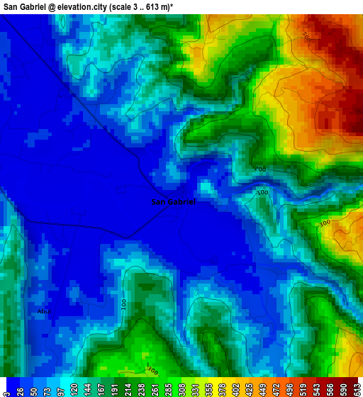
Below is the Elevation map of San Gabriel, which displays elevation range with different colors. Scale of the first map is from 3 to 613 m (10 to 2011 ft) with average elevation of 147.4 meters (=484 ft) [note 1]
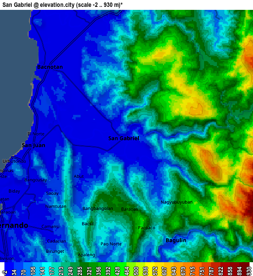
These maps also provides idea of topography and contour of this city, they are displayed at different zoom levels. More info about maps, scale and edge coordinates you can find below images.
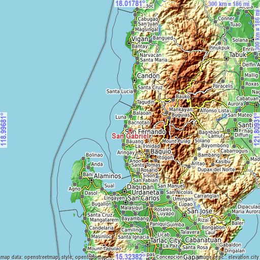
| \ | Map #1 | Map #2 | Topo.Map |
| Scale [m] | 3..613 m | -2..930 m | × |
| Scale [ft] | 10..2011 ft | -7..3051 ft | × |
| Average | 147.4 m = 484 ft | 206.5 m = 677 ft | × |
| Width | 9.36 km = 5.8 mi | 18.72 km = 11.6 mi | 299.5 km = 186.1 mi |
| Height | 9.36 km = 5.8 mi | 18.72 km = 11.6 mi | 299.6 km = 186.2 mi |
| ↑Max Latitude | 16.717653° | 16.759736° | 18.01781° |
| Latitude at center | 16.67556° | 16.67556° | 16.67556° |
| ↓Min Latitude | 16.633458° | 16.591347° | 15.32382° |
| ← Min Longitude | 120.359115° | 120.315169° | 118.99681° |
| Longitude center | 120.40306° | 120.40306° | 120.40306° |
| →Max Longitude | 120.447005° | 120.490951° | 121.80931° |
Nearby cities:
Cities around San Gabriel sort by population:
• San Fernando elevation 9 m
11.3 km,  234°
234°
• Paringao 7 m
14.3 km,  216°
216°
• Acao 41 m
16.9 km,  189°
189°
• Butubut Norte 28 m
14.6 km,  13°
13°
• Bacnotan 11 m
7.5 km,  313°
313°
• Balaoan 14 m
16.3 km,  0°
0°
• Corrooy 32 m
14.1 km,  18°
18°
• Dagup 439 m
6.2 km,  133°
133°
• Bagulin 67 m
8.4 km,  152°
152°
• Naguilian 20 m
15.8 km,  182°
182°
• Santol 74 m
12.3 km,  29°
29°
• San Juan 8 m
6.6 km,  263°
263°
Multilingual:
 En español:
San Gabriel elevación 23 m.
 En France:
San Gabriel élévation 23 m.
 Auf Deutsch:
San Gabriel höhe über dem Meeresspiegel ist 23 m.

Sources and notes:
- [note 1] Map square and city borders are not equal. Map elevation data is calculated only from area inside that square.
- [src 1] Elevation data from geonames database provided with same terms of usage.
- [src 2] The elevation map of San Gabriel is generated using elevation data from NASA's 3 arcsec (90m) resolution SRTM data.
- [src 3] Base (background) map © OpenStreetMap contributors tiles are generated by Geofabrik and OpenTopoMap.
Copyright & License:
This San Gabriel Elevation Map is licensed under CC BY-SA. You may reuse any part from this page, if you give a proper credit by linking to this URL:
 More info on terms of use page.